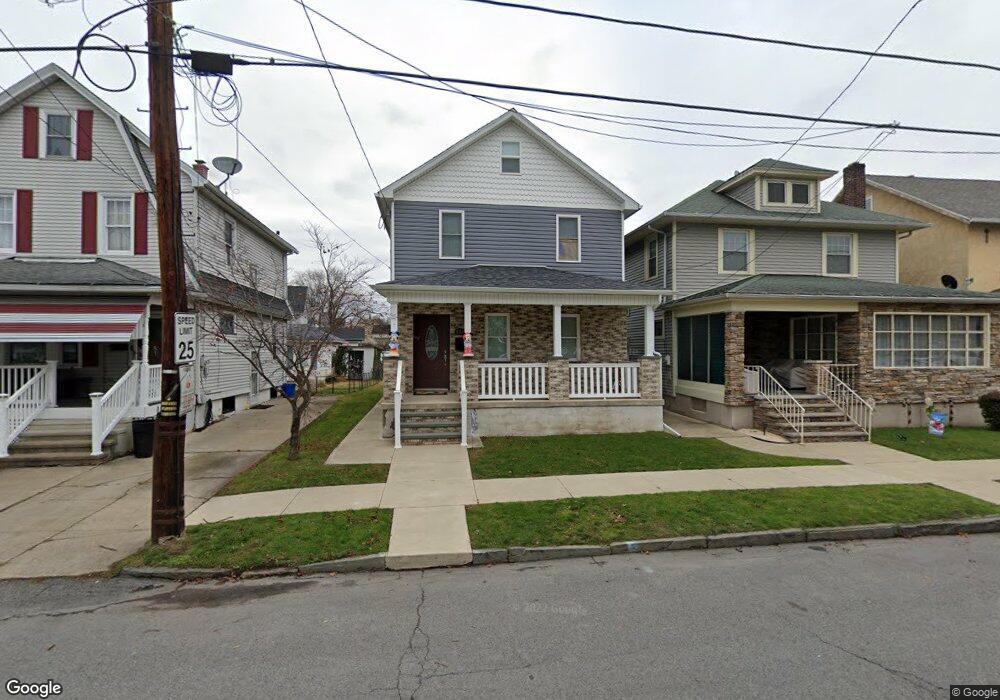
609 Race St Scranton, PA 18509
Providence NeighborhoodEstimated Value: $138,000 - $171,000
3
Beds
1
Bath
1,200
Sq Ft
$129/Sq Ft
Est. Value
About This Home
This home is located at 609 Race St, Scranton, PA 18509 and is currently estimated at $155,375, approximately $129 per square foot. 609 Race St is a home located in Lackawanna County with nearby schools including Maybeury Elementary School, Pinchbeck Elementary School, and Robert Morris #27.
Ownership History
Date
Name
Owned For
Owner Type
Purchase Details
Closed on
Nov 10, 2017
Sold by
Boczar Robert J
Bought by
Boczar Robert J
Current Estimated Value
Purchase Details
Closed on
Aug 7, 2017
Sold by
Boczar Amanda M
Bought by
Boczar Robert J
Purchase Details
Closed on
Nov 18, 2011
Sold by
Eh Pooled 1011 Lp
Bought by
Boczar Roebrt J and Boczar Amanda M
Purchase Details
Closed on
Nov 10, 2011
Sold by
Deutsche Bank Trust Company
Bought by
Eh Pooled 1011 Lp
Create a Home Valuation Report for This Property
The Home Valuation Report is an in-depth analysis detailing your home's value as well as a comparison with similar homes in the area
Home Values in the Area
Average Home Value in this Area
Purchase History
| Date | Buyer | Sale Price | Title Company |
|---|---|---|---|
| Boczar Robert J | -- | -- | |
| Boczar Robert J | -- | None Available | |
| Boczar Roebrt J | $23,500 | None Available | |
| Eh Pooled 1011 Lp | $60,390 | Title & Abstract Reo Inc |
Source: Public Records
Tax History Compared to Growth
Tax History
| Year | Tax Paid | Tax Assessment Tax Assessment Total Assessment is a certain percentage of the fair market value that is determined by local assessors to be the total taxable value of land and additions on the property. | Land | Improvement |
|---|---|---|---|---|
| 2025 | $2,734 | $8,500 | $1,350 | $7,150 |
| 2024 | $2,499 | $8,500 | $1,350 | $7,150 |
| 2023 | $2,499 | $8,500 | $1,350 | $7,150 |
| 2022 | $2,444 | $8,500 | $1,350 | $7,150 |
| 2021 | $2,444 | $8,500 | $1,350 | $7,150 |
| 2020 | $2,398 | $8,500 | $1,350 | $7,150 |
| 2019 | $2,256 | $8,500 | $1,350 | $7,150 |
| 2018 | $2,256 | $8,500 | $1,350 | $7,150 |
| 2017 | $2,216 | $8,500 | $1,350 | $7,150 |
| 2016 | $675 | $8,500 | $1,350 | $7,150 |
| 2015 | $1,662 | $8,500 | $1,350 | $7,150 |
| 2014 | -- | $8,500 | $1,350 | $7,150 |
Source: Public Records
Map
Nearby Homes
- 2129 Comegys Ave Unit L11
- 2106 Boulevard Ave
- 601 Dean St
- 2237 Boulevard Ave
- 2136 N Main Ave
- 35 Dean St
- 512 Electric St Unit 510-516
- 1762-1764 Sanderson Ave
- 416 Electric St
- 1747 Monsey Ave
- 1021 Richmont St
- 802 Sunset St
- 2089 N Main Ave
- 119 Spring St
- 1008 Fisk St
- 121 Throop St
- 1732 Capouse Ave
- 2040 Edna Ave
- 2105 Belmont Terrace
- 831 Raines St
- 605 Race St
- 617 Race St
- 619 Race St
- 2112 Comegys Ave
- 2116 Comegys Ave
- 2102 Comegys Ave
- 621 Race St
- 2117 Shawnee Ave
- 2115 Shawnee Ave
- 2120 Comegys Ave
- 2105 Shawnee Ave
- 608 Race St
- 2122 Comegys Ave
- 620 Race St
- 2101 Comegys Ave Unit L4
- 2121 Shawnee Ave
- 2124 Comegys Ave
- 622 Race St
- 2123 Shawnee Ave
- 515 Race St