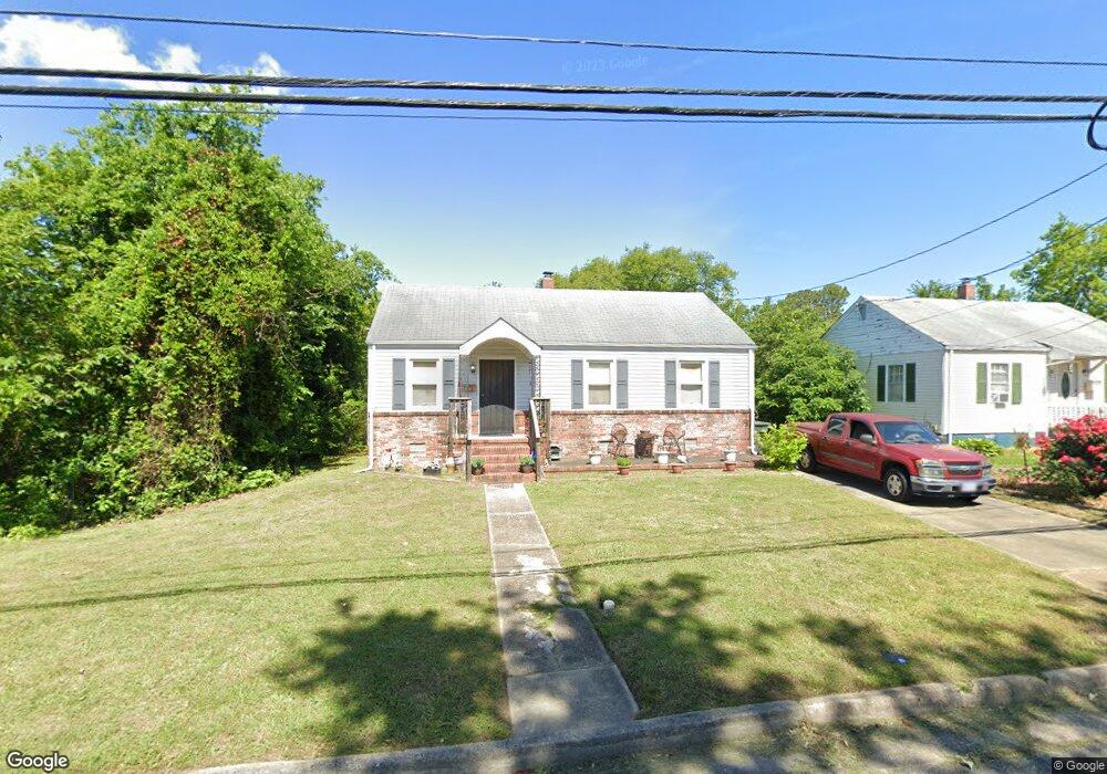
61 Huffman Dr Hampton, VA 23669
Old North Hampton NeighborhoodEstimated Value: $178,000 - $200,000
3
Beds
1
Bath
784
Sq Ft
$242/Sq Ft
Est. Value
About This Home
This home is located at 61 Huffman Dr, Hampton, VA 23669 and is currently estimated at $190,117, approximately $242 per square foot. 61 Huffman Dr is a home located in Hampton City with nearby schools including Barron Elementary School, Albert W. Patrick III Elementary School, and Benjamin Syms Middle School.
Ownership History
Date
Name
Owned For
Owner Type
Purchase Details
Closed on
Jun 11, 2000
Sold by
Bradley Emmett
Bought by
Walker Fredrick
Current Estimated Value
Home Financials for this Owner
Home Financials are based on the most recent Mortgage that was taken out on this home.
Original Mortgage
$54,000
Outstanding Balance
$19,064
Interest Rate
8.24%
Estimated Equity
$171,053
Create a Home Valuation Report for This Property
The Home Valuation Report is an in-depth analysis detailing your home's value as well as a comparison with similar homes in the area
Home Values in the Area
Average Home Value in this Area
Purchase History
| Date | Buyer | Sale Price | Title Company |
|---|---|---|---|
| Walker Fredrick | $54,000 | -- |
Source: Public Records
Mortgage History
| Date | Status | Borrower | Loan Amount |
|---|---|---|---|
| Open | Walker Fredrick | $54,000 |
Source: Public Records
Tax History
| Year | Tax Paid | Tax Assessment Tax Assessment Total Assessment is a certain percentage of the fair market value that is determined by local assessors to be the total taxable value of land and additions on the property. | Land | Improvement |
|---|---|---|---|---|
| 2025 | $1,991 | $174,800 | $48,200 | $126,600 |
| 2024 | $1,693 | $147,200 | $48,200 | $99,000 |
| 2023 | $1,453 | $125,300 | $48,200 | $77,100 |
| 2022 | $1,407 | $119,200 | $48,200 | $71,000 |
| 2021 | $1,292 | $93,700 | $34,200 | $59,500 |
| 2020 | $1,156 | $93,200 | $34,200 | $59,000 |
| 2019 | $1,091 | $88,000 | $34,200 | $53,800 |
| 2018 | $1,195 | $87,300 | $34,200 | $53,100 |
| 2017 | $1,176 | $0 | $0 | $0 |
| 2016 | $1,214 | $90,300 | $0 | $0 |
| 2015 | $1,214 | $0 | $0 | $0 |
| 2014 | $1,232 | $90,300 | $34,200 | $56,100 |
Source: Public Records
Map
Nearby Homes
- 845 N King St
- 925 Quash St
- 138 Eberly Terrace
- 994 N King St
- 8 Saxony Place
- 8 N Gawain Way
- 22 Lucas Dr
- 28 N Gawain Way
- 311 Cooper St
- 33 Clayton Dr
- 10 Eberly Terrace
- 314 Cooper St
- 603 Washington St
- 606 Washington St
- 226 Island Cove Ct Unit C
- 433 Cooper St
- 439 Cooper St
- 221 Island Cove Ct Unit C
- 418 Wine St
- 720 River St
Your Personal Tour Guide
Ask me questions while you tour the home.