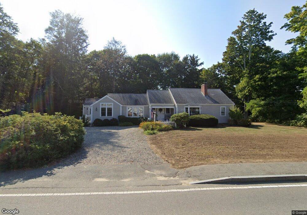
61 Main St Cotuit, MA 02635
Cotuit NeighborhoodEstimated Value: $823,000 - $1,100,000
3
Beds
3
Baths
2,277
Sq Ft
$397/Sq Ft
Est. Value
About This Home
This home is located at 61 Main St, Cotuit, MA 02635 and is currently estimated at $903,786, approximately $396 per square foot. 61 Main St is a home located in Barnstable County with nearby schools including West Villages Elementary School, Barnstable United Elementary School, and Barnstable Intermediate School.
Ownership History
Date
Name
Owned For
Owner Type
Purchase Details
Closed on
Nov 10, 2025
Sold by
Wysocki Edward P
Bought by
Wysocki Marilyn A
Current Estimated Value
Purchase Details
Closed on
May 8, 2019
Sold by
Wysocki Edward P and Wysocki Marilyn A
Bought by
Karo Kara
Purchase Details
Closed on
May 29, 1998
Sold by
Almeida Hilda M Est and Powers
Bought by
Wysocki Edward P and Wysocki Marilyn A
Home Financials for this Owner
Home Financials are based on the most recent Mortgage that was taken out on this home.
Original Mortgage
$100,000
Interest Rate
7.12%
Mortgage Type
Purchase Money Mortgage
Create a Home Valuation Report for This Property
The Home Valuation Report is an in-depth analysis detailing your home's value as well as a comparison with similar homes in the area
Home Values in the Area
Average Home Value in this Area
Purchase History
| Date | Buyer | Sale Price | Title Company |
|---|---|---|---|
| Wysocki Marilyn A | -- | -- | |
| Karo Kara | -- | -- | |
| Wysocki Edward P | $130,000 | -- |
Source: Public Records
Mortgage History
| Date | Status | Borrower | Loan Amount |
|---|---|---|---|
| Previous Owner | Wysocki Edward P | $100,000 |
Source: Public Records
Tax History
| Year | Tax Paid | Tax Assessment Tax Assessment Total Assessment is a certain percentage of the fair market value that is determined by local assessors to be the total taxable value of land and additions on the property. | Land | Improvement |
|---|---|---|---|---|
| 2025 | $6,608 | $791,400 | $197,000 | $594,400 |
| 2024 | $5,983 | $759,300 | $197,000 | $562,300 |
| 2023 | $5,794 | $692,200 | $194,700 | $497,500 |
| 2022 | $5,785 | $559,500 | $138,400 | $421,100 |
| 2021 | $5,438 | $492,500 | $138,400 | $354,100 |
| 2020 | $5,618 | $479,800 | $138,400 | $341,400 |
| 2019 | $5,236 | $440,700 | $138,400 | $302,300 |
| 2018 | $3,471 | $414,400 | $151,800 | $262,600 |
| 2017 | $4,745 | $402,100 | $151,800 | $250,300 |
| 2016 | $4,582 | $398,100 | $147,800 | $250,300 |
| 2015 | $4,614 | $400,500 | $150,300 | $250,200 |
Source: Public Records
Map
Nearby Homes
- 226 Dunrobin Rd
- 75 Bob White Run
- 70 Cape Dr Unit 14D
- 70 Cape Dr Unit 11D
- 70 Cape Dr Unit 11D
- 16 Spring Brook Ln
- 4 Bishops Park
- 1456 Santuit-Newtown Rd
- 22 Stratford Ridge Unit 22
- 170 Forest Hills Rd
- 70 Simons Rd Unit E
- 70 Simons Rd
- 173 Main St
- 239 Oxford Dr
- 195 Falmouth Rd Unit 19F
- 195 Falmouth Rd Unit 9D
- 195 Falmouth Rd Unit 19F
- 602 Putnam Ave
- 35 Claulise Ln
- 15 Geraldine Rd
Your Personal Tour Guide
Ask me questions while you tour the home.