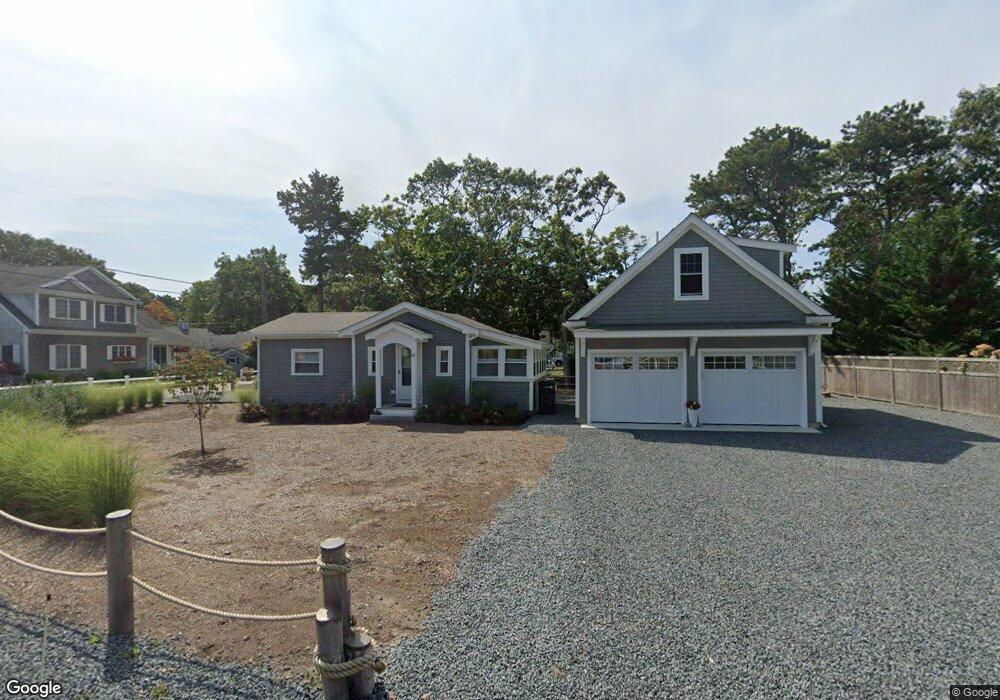
61 Seconsett Island Rd Mashpee, MA 02649
Seconsett Island NeighborhoodEstimated Value: $644,495 - $741,000
2
Beds
1
Bath
586
Sq Ft
$1,193/Sq Ft
Est. Value
About This Home
This home is located at 61 Seconsett Island Rd, Mashpee, MA 02649 and is currently estimated at $699,374, approximately $1,193 per square foot. 61 Seconsett Island Rd is a home located in Barnstable County with nearby schools including Kenneth C. Coombs School, Quashnet School, and Mashpee Middle School.
Ownership History
Date
Name
Owned For
Owner Type
Purchase Details
Closed on
Dec 21, 2021
Sold by
Locke Edward C
Bought by
Disciullo David J and Disciullo Elyse S
Current Estimated Value
Home Financials for this Owner
Home Financials are based on the most recent Mortgage that was taken out on this home.
Original Mortgage
$393,750
Outstanding Balance
$359,994
Interest Rate
2.98%
Mortgage Type
Purchase Money Mortgage
Estimated Equity
$339,380
Purchase Details
Closed on
May 23, 1966
Bought by
Locke Edward C
Create a Home Valuation Report for This Property
The Home Valuation Report is an in-depth analysis detailing your home's value as well as a comparison with similar homes in the area
Home Values in the Area
Average Home Value in this Area
Purchase History
| Date | Buyer | Sale Price | Title Company |
|---|---|---|---|
| Disciullo David J | $525,000 | None Available | |
| Locke Edward C | -- | -- |
Source: Public Records
Mortgage History
| Date | Status | Borrower | Loan Amount |
|---|---|---|---|
| Open | Disciullo David J | $393,750 |
Source: Public Records
Tax History Compared to Growth
Tax History
| Year | Tax Paid | Tax Assessment Tax Assessment Total Assessment is a certain percentage of the fair market value that is determined by local assessors to be the total taxable value of land and additions on the property. | Land | Improvement |
|---|---|---|---|---|
| 2025 | $3,658 | $552,500 | $354,500 | $198,000 |
| 2024 | $2,630 | $409,000 | $322,300 | $86,700 |
| 2023 | $2,601 | $371,100 | $283,300 | $87,800 |
| 2022 | $2,468 | $302,100 | $230,300 | $71,800 |
| 2021 | $2,445 | $269,600 | $207,500 | $62,100 |
| 2020 | $2,330 | $256,300 | $199,500 | $56,800 |
| 2019 | $2,384 | $263,400 | $216,200 | $47,200 |
| 2018 | $2,320 | $260,100 | $216,200 | $43,900 |
| 2017 | $2,348 | $255,500 | $216,200 | $39,300 |
| 2016 | $2,336 | $252,800 | $216,200 | $36,600 |
| 2015 | $2,285 | $250,800 | $216,200 | $34,600 |
| 2014 | $2,034 | $216,600 | $182,500 | $34,100 |
Source: Public Records
Map
Nearby Homes
- 12 Mizzenmast
- 50 Topping Lift
- 43 Neshobe Rd
- 183 Monomoscoy Rd
- 9 Point Rd
- 5 Tide Run
- 381 Great Oak Rd Unit 9
- 59 Mashie Cir
- 3 Niblick Ln
- 72 Walton Heath Way
- 51 Walton Heath Way
- 51 Fairway Ln
- 15 Pershing Dr
- 11 Pershing Dr
- 7 Yale Dr
- 240 Surf Dr
- 224 Waquoit Hwy
- 42 Overlook Cir
- 50 Rivers Edge Rd
- 4 Bigelow Lndg Rd
- 57 Seconsett Island Rd
- 62 Seconsett Island Rd
- 56 Seconsett Island Rd
- 5 Kanter Ln
- 53 Seconsett Island Rd
- 2 Seconsett Point Rd
- 71 Seconsett Island Rd
- 9 Kanter Ln
- 51 Seconsett Island Rd
- 68 Seconsett Island Rd
- 2 Bayview Rd
- 5 Bayview Rd
- 8 Seconsett Point Rd
- 8 Kanter Ln
- 4 Slippershell
- 6 Kanter Ln
- 75 Seconsett Island Rd
- 72 Seconsett Island Rd
- 49 Seconsett Island Rd
- 12 Riverside Rd