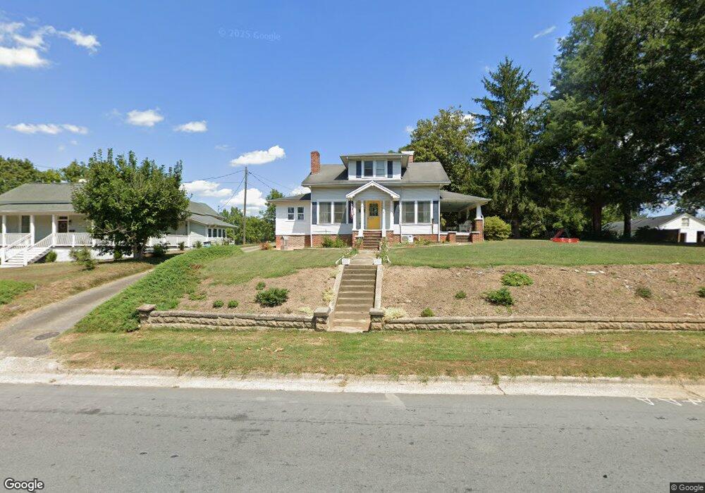
610 N Grove St Lincolnton, NC 28092
Estimated Value: $261,000 - $292,000
3
Beds
1
Bath
1,548
Sq Ft
$182/Sq Ft
Est. Value
About This Home
This home is located at 610 N Grove St, Lincolnton, NC 28092 and is currently estimated at $281,827, approximately $182 per square foot. 610 N Grove St is a home located in Lincoln County with nearby schools including Battleground Elementary School, Lincolnton Middle School, and Lincolnton High School.
Ownership History
Date
Name
Owned For
Owner Type
Purchase Details
Closed on
Mar 7, 2019
Sold by
Dernlan Ira Llc
Bought by
Johnson Michael A and Johnson Kathleen M
Current Estimated Value
Home Financials for this Owner
Home Financials are based on the most recent Mortgage that was taken out on this home.
Original Mortgage
$126,074
Outstanding Balance
$113,407
Interest Rate
5.62%
Mortgage Type
FHA
Estimated Equity
$168,420
Purchase Details
Closed on
Oct 24, 2017
Sold by
Robinson Emily Allran and Robinson Paul Ben
Bought by
Dernlan I R A Llc
Create a Home Valuation Report for This Property
The Home Valuation Report is an in-depth analysis detailing your home's value as well as a comparison with similar homes in the area
Home Values in the Area
Average Home Value in this Area
Purchase History
| Date | Buyer | Sale Price | Title Company |
|---|---|---|---|
| Johnson Michael A | $129,000 | None Available | |
| Dernlan I R A Llc | $118,000 | None Available |
Source: Public Records
Mortgage History
| Date | Status | Borrower | Loan Amount |
|---|---|---|---|
| Open | Johnson Michael A | $126,074 |
Source: Public Records
Tax History Compared to Growth
Tax History
| Year | Tax Paid | Tax Assessment Tax Assessment Total Assessment is a certain percentage of the fair market value that is determined by local assessors to be the total taxable value of land and additions on the property. | Land | Improvement |
|---|---|---|---|---|
| 2025 | $2,667 | $252,999 | $33,322 | $219,677 |
| 2024 | $2,647 | $252,999 | $33,322 | $219,677 |
| 2023 | $2,647 | $252,999 | $33,322 | $219,677 |
| 2022 | $1,672 | $132,093 | $22,548 | $109,545 |
| 2021 | $1,583 | $128,552 | $22,548 | $106,004 |
| 2020 | $1,490 | $128,552 | $22,548 | $106,004 |
| 2019 | $1,490 | $128,552 | $22,548 | $106,004 |
| 2018 | $1,309 | $103,144 | $21,370 | $81,774 |
| 2017 | $1,208 | $103,144 | $21,370 | $81,774 |
| 2016 | $1,208 | $103,144 | $21,370 | $81,774 |
| 2015 | $1,270 | $103,144 | $21,370 | $81,774 |
| 2014 | $1,406 | $114,269 | $22,785 | $91,484 |
Source: Public Records
Map
Nearby Homes
- 502 Forney Ave
- 535 Norman Fair Ave
- 327 Bonview Ave
- 801 N Grove St
- 524 Bonview Ave
- 411 W Sycamore St
- 316 N Government St
- 627 W Main St
- 317 S High St
- 668 Riverside Dr
- 743 Lore Rd
- 423 N Cedar St
- 815 N Laurel St
- 665 S Grove St
- 681 S Grove St
- 689 S Grove St
- 697 S Grove St
- 826 E Alexander St
- 515 S Academy St
- 329 E Congress St
- 614 N Grove St
- 602 N Grove St
- 611 N Grove St
- 702 N Grove St
- 526 N Grove St
- 601 N Grove St
- 619 N Grove St
- 0 Victor St Unit 836623
- 529 N Grove St
- 525 N Grove St
- 522 N Grove St
- 132 Linwood Dr
- 708 N Grove St
- 402 Victor St
- 126 Linwood Dr
- 416 Louise Ave
- 222 Linwood Dr
- 300 Linwood Dr
- 423 Victor St
- 519 N Grove St