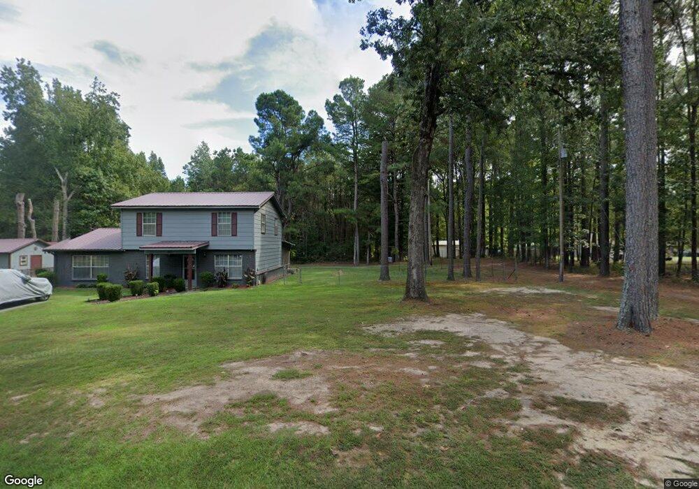
611 Monk Rd White Hall, AR 71602
Estimated Value: $151,007 - $186,000
--
Bed
2
Baths
1,848
Sq Ft
$91/Sq Ft
Est. Value
About This Home
This home is located at 611 Monk Rd, White Hall, AR 71602 and is currently estimated at $168,002, approximately $90 per square foot. 611 Monk Rd is a home located in Jefferson County with nearby schools including Matthews Elementary School, Robert F. Morehead Middle School, and Dollarway High School.
Ownership History
Date
Name
Owned For
Owner Type
Purchase Details
Closed on
Jun 17, 2008
Sold by
Walker Parnell
Bought by
Walker Vivian
Current Estimated Value
Purchase Details
Closed on
Dec 4, 1995
Bought by
Walker Parnell and Walker Wf
Purchase Details
Closed on
Feb 18, 1993
Bought by
Smith Vivian Varnell
Purchase Details
Closed on
May 16, 1989
Bought by
Gracie Barry D and Gracie Sandra D
Purchase Details
Closed on
Nov 10, 1988
Bought by
Simmons First National Bank
Purchase Details
Closed on
Jan 1, 1910
Bought by
Gullett Benjamin M and Gullett Wf
Create a Home Valuation Report for This Property
The Home Valuation Report is an in-depth analysis detailing your home's value as well as a comparison with similar homes in the area
Home Values in the Area
Average Home Value in this Area
Purchase History
| Date | Buyer | Sale Price | Title Company |
|---|---|---|---|
| Walker Vivian | -- | -- | |
| Walker Parnell | -- | -- | |
| Smith Vivian Varnell | $49,000 | -- | |
| Gracie Barry D | -- | -- | |
| Simmons First National Bank | -- | -- | |
| Gullett Benjamin M | -- | -- |
Source: Public Records
Tax History Compared to Growth
Tax History
| Year | Tax Paid | Tax Assessment Tax Assessment Total Assessment is a certain percentage of the fair market value that is determined by local assessors to be the total taxable value of land and additions on the property. | Land | Improvement |
|---|---|---|---|---|
| 2025 | $257 | $24,250 | $2,000 | $22,250 |
| 2024 | $357 | $24,250 | $2,000 | $22,250 |
| 2023 | $432 | $24,250 | $2,000 | $22,250 |
| 2022 | $343 | $14,230 | $700 | $13,530 |
| 2021 | $343 | $14,230 | $700 | $13,530 |
| 2020 | $328 | $14,230 | $700 | $13,530 |
| 2019 | $297 | $14,230 | $700 | $13,530 |
| 2018 | $292 | $14,230 | $700 | $13,530 |
| 2017 | $261 | $12,110 | $700 | $11,410 |
| 2016 | $261 | $12,110 | $700 | $11,410 |
| 2015 | $258 | $12,110 | $700 | $11,410 |
| 2014 | -- | $12,110 | $700 | $11,410 |
Source: Public Records
Map
Nearby Homes
- 1003 Camp Rd
- 10115 Highway 270
- 9403 U S 270
- 412 Highway 104
- 410 Rolling Hills Dr
- 1920 Allbritton Dr
- TBD Elkins Rd
- 199 Hardin Reed Rd
- 0 Michael Ann Dr
- 1506 Oakwood Cir
- 1018 W Holland Ave
- 8800 Highway 270
- 1107 Katie Ln
- 8701 Highway 270
- 102 Farah Dr
- 1005 Shephard Dr
- 226 Shamsie Ln
- 617 Winchester Ave
- 10200 Dollarway Rd
- 0000 Lanni Ln