
Seller's Agent in 2026
Brent Johnson
Keller Williams Realty Integrity
(612) 298-5000
3 in this area
120 Total Sales
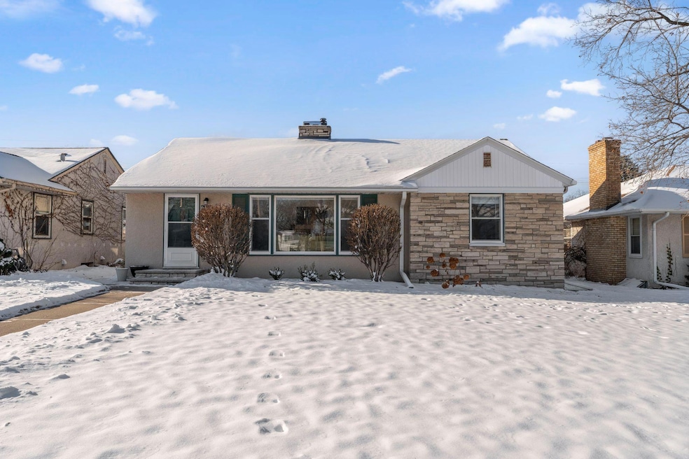


Discover the epitome of pride in ownership in this immaculate South Minneapolis residence, perfectly situated in the desirable Diamond Lake neighborhood. This solid, well-built 3-bedroom, 1-bathroom home radiates warmth and style, featuring tasteful decor that perfectly highlights its classic architectural charm. The heart of the home is the inviting living area, anchored by a wonderful fireplace that serves as the perfect focal point for cozy Minnesota evenings. This home has been incredibly well cared for, offering a true "turn-key" experience for the next owner. The lower level extends your living space with a partially finished basement, ideal for a home office or recreation room. Outside, enjoy a fenced and private backyard retreat. The detached 1-car garage features a unique and lovely attached patio, creating an enchanting setting for alfresco dining and summer entertaining. With convenient access to parks, lakes, and local shops, this beautiful home is a rare find.
Last Agent to Sell the Property
Keller Williams Realty Integrity Listed on: 12/05/2025
| Date | Type | Sale Price | Title Company |
|---|---|---|---|
| Warranty Deed | $365,000 | Great North Title | |
| Personal Reps Deed | $279,000 | Minnesota Title | |
| Warranty Deed | $112,000 | -- |
| Date | Status | Loan Amount | Loan Type |
|---|---|---|---|
| Open | $346,750 | New Conventional | |
| Previous Owner | $270,630 | New Conventional |
| Date | Event | Price | List to Sale | Price per Sq Ft |
|---|---|---|---|---|
| 01/21/2026 01/21/26 | Sold | $365,000 | 0.0% | $235 / Sq Ft |
| 12/19/2025 12/19/25 | Pending | -- | -- | -- |
| 12/05/2025 12/05/25 | For Sale | $365,000 | -- | $235 / Sq Ft |
| Year | Tax Paid | Tax Assessment Tax Assessment Total Assessment is a certain percentage of the fair market value that is determined by local assessors to be the total taxable value of land and additions on the property. | Land | Improvement |
|---|---|---|---|---|
| 2024 | $4,570 | $324,000 | $134,000 | $190,000 |
| 2023 | $4,126 | $324,000 | $120,000 | $204,000 |
| 2022 | $3,730 | $324,000 | $103,000 | $221,000 |
| 2021 | $3,281 | $280,000 | $63,000 | $217,000 |
| 2020 | $3,555 | $257,500 | $71,000 | $186,500 |
| 2019 | $3,463 | $257,500 | $47,300 | $210,200 |
| 2018 | $3,188 | $245,000 | $47,300 | $197,700 |
| 2017 | $2,995 | $210,500 | $43,000 | $167,500 |
| 2016 | $2,793 | $193,000 | $43,000 | $150,000 |
| 2015 | $2,930 | $193,000 | $43,000 | $150,000 |
| 2014 | -- | $184,000 | $46,000 | $138,000 |
Seller's Agent in 2026
Brent Johnson
Keller Williams Realty Integrity
(612) 298-5000
3 in this area
120 Total Sales
Buyer's Agent in 2026
Lisa LaCombe
Coldwell Banker Realty - Southwest Regional
(612) 616-1795
2 in this area
62 Total Sales
Source: NorthstarMLS
MLS Number: 6824194
APN: 23-028-24-34-0095
Disclaimer: Certain information contained herein is derived from information provided by parties other than Homes.com. All information provided is deemed reliable, but is not guaranteed to be accurate and should be independently verified.
![]() Based on information submitted to the MLS GRID. All data is obtained from various sources and may not have been verified by broker or MLS GRID. Supplied Open House Information is subject to change without notice. All information should be independently reviewed and verified for accuracy. Properties may or may not be listed by the office/agent presenting the information. Some IDX listings have been excluded from this website.
Based on information submitted to the MLS GRID. All data is obtained from various sources and may not have been verified by broker or MLS GRID. Supplied Open House Information is subject to change without notice. All information should be independently reviewed and verified for accuracy. Properties may or may not be listed by the office/agent presenting the information. Some IDX listings have been excluded from this website.
Based on information submitted to the MLS GRID
Ask me questions while you tour the home.