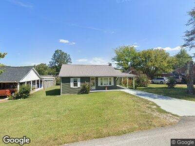
613 S High St Waynesboro, TN 38485
Estimated Value: $79,475 - $114,000
--
Bed
1
Bath
912
Sq Ft
$102/Sq Ft
Est. Value
About This Home
This home is located at 613 S High St, Waynesboro, TN 38485 and is currently estimated at $92,619, approximately $101 per square foot. 613 S High St is a home located in Wayne County with nearby schools including Wayne Academy.
Ownership History
Date
Name
Owned For
Owner Type
Purchase Details
Closed on
Jan 17, 2023
Sold by
Equity Trust Company
Bought by
Ploegstra John and Ploegstra Holly
Current Estimated Value
Purchase Details
Closed on
Dec 24, 2021
Sold by
Mathis Pamela and Jones Pamela Mathis
Bought by
Davis Hannah
Purchase Details
Closed on
Jun 26, 2015
Sold by
Tatum Harold
Bought by
Mathis Pamela
Home Financials for this Owner
Home Financials are based on the most recent Mortgage that was taken out on this home.
Original Mortgage
$34,500
Interest Rate
3.93%
Mortgage Type
New Conventional
Purchase Details
Closed on
May 9, 1994
Bought by
Tatum Jessie Mae
Purchase Details
Closed on
Feb 25, 1994
Bought by
Estes Carlton W
Purchase Details
Closed on
Apr 23, 1991
Bought by
Pulley Helen Louise
Purchase Details
Closed on
Nov 11, 1974
Bought by
Pulley Helen Louise
Create a Home Valuation Report for This Property
The Home Valuation Report is an in-depth analysis detailing your home's value as well as a comparison with similar homes in the area
Home Values in the Area
Average Home Value in this Area
Purchase History
| Date | Buyer | Sale Price | Title Company |
|---|---|---|---|
| Ploegstra John | $19,000 | -- | |
| Davis Hannah | -- | None Available | |
| Mathis Pamela | $39,500 | -- | |
| Tatum Jessie Mae | $20,000 | -- | |
| Estes Carlton W | $14,000 | -- | |
| Pulley Helen Louise | $15,300 | -- | |
| Pulley Helen Louise | -- | -- |
Source: Public Records
Mortgage History
| Date | Status | Borrower | Loan Amount |
|---|---|---|---|
| Previous Owner | Mathis Pamela | $34,500 |
Source: Public Records
Tax History Compared to Growth
Tax History
| Year | Tax Paid | Tax Assessment Tax Assessment Total Assessment is a certain percentage of the fair market value that is determined by local assessors to be the total taxable value of land and additions on the property. | Land | Improvement |
|---|---|---|---|---|
| 2024 | $279 | $12,875 | $1,500 | $11,375 |
| 2023 | $154 | $12,875 | $1,500 | $11,375 |
| 2022 | $401 | $12,875 | $1,500 | $11,375 |
| 2021 | $373 | $12,875 | $1,500 | $11,375 |
| 2020 | $373 | $9,950 | $1,250 | $8,700 |
| 2019 | $288 | $9,950 | $1,250 | $8,700 |
| 2018 | $373 | $9,950 | $1,250 | $8,700 |
| 2017 | $373 | $9,950 | $1,250 | $8,700 |
| 2016 | $348 | $9,950 | $1,250 | $8,700 |
| 2014 | -- | $6,816 | $0 | $0 |
Source: Public Records
Map
Nearby Homes
- 107 W Songer St
- 110 Turman St
- 311 W Hill St
- 310 W Hill St
- 0 U S Highway 64
- 0 Waynesboro Hwy Unit RTC2821045
- 0 Waynesboro Hwy Unit RTC2806893
- 446 Kilburn Hollow Rd
- 0 Simmons Branch Rd Unit 10181446
- 656 Waynesboro Hwy
- 123 Will Dr
- 152 Mink Branch Rd
- 0 Leonard Jackson Rd Unit RTC2866603
- 1272 Old Highway 64 E
- 5081 Sunny Acres Dr
- 1141 Lawrenceburg Hwy
- 0 Keeton Rd
- 0 Moccasin Creek Rd
- 1717 Collinwood Hwy
- 1 Scott Ridge Rd