Estimated Value: $210,000 - $230,000
2
Beds
1
Bath
2,171
Sq Ft
$103/Sq Ft
Est. Value
About This Home
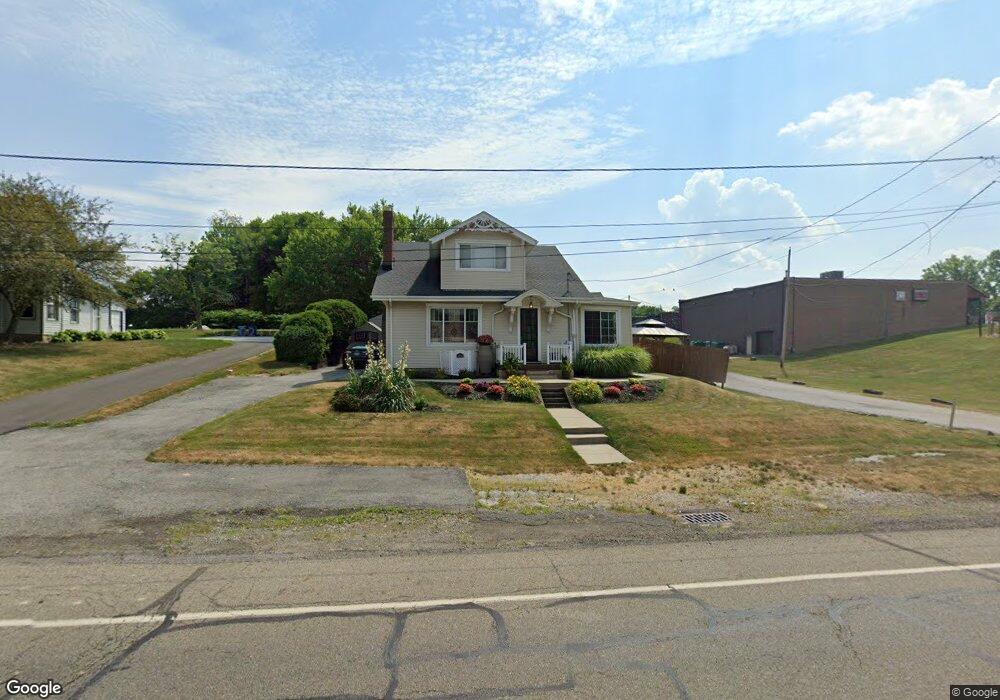
This home is located at 6141 Manchester Rd, Akron, OH 44319 and is currently estimated at $223,184, approximately $102 per square foot. 6141 Manchester Rd is a home located in Summit County with nearby schools including Manchester Middle School, Nolley Elementary School, and Manchester High School.
Ownership History
Date
Name
Owned For
Owner Type
Purchase Details
Closed on
Feb 13, 1995
Sold by
Macintyre Douglas S
Bought by
Collins Thomas W and Collins Maria V
Current Estimated Value
Home Financials for this Owner
Home Financials are based on the most recent Mortgage that was taken out on this home.
Original Mortgage
$70,550
Interest Rate
9.21%
Mortgage Type
New Conventional
Create a Home Valuation Report for This Property
The Home Valuation Report is an in-depth analysis detailing your home's value as well as a comparison with similar homes in the area
Home Values in the Area
Average Home Value in this Area
Purchase History
| Date | Buyer | Sale Price | Title Company |
|---|---|---|---|
| Collins Thomas W | $75,000 | -- |
Source: Public Records
Mortgage History
| Date | Status | Borrower | Loan Amount |
|---|---|---|---|
| Closed | Collins Thomas W | $70,550 |
Source: Public Records
Tax History Compared to Growth
Tax History
| Year | Tax Paid | Tax Assessment Tax Assessment Total Assessment is a certain percentage of the fair market value that is determined by local assessors to be the total taxable value of land and additions on the property. | Land | Improvement |
|---|---|---|---|---|
| 2025 | $2,968 | $58,818 | $8,743 | $50,075 |
| 2024 | $2,968 | $58,818 | $8,743 | $50,075 |
| 2023 | $2,968 | $58,818 | $8,743 | $50,075 |
| 2022 | $2,850 | $43,988 | $6,524 | $37,464 |
| 2021 | $2,859 | $43,988 | $6,524 | $37,464 |
| 2020 | $2,810 | $43,980 | $6,520 | $37,460 |
| 2019 | $2,712 | $38,000 | $6,520 | $31,480 |
| 2018 | $2,342 | $38,000 | $6,520 | $31,480 |
| 2017 | $2,216 | $38,000 | $6,520 | $31,480 |
| 2016 | $2,195 | $32,630 | $6,520 | $26,110 |
| 2015 | $2,216 | $32,630 | $6,520 | $26,110 |
| 2014 | $2,170 | $32,150 | $6,520 | $25,630 |
| 2013 | $2,342 | $34,950 | $6,520 | $28,430 |
Source: Public Records
Map
Nearby Homes
- 877 W Nimisila Rd
- 1062 Stump Rd
- 5898 Keller Rd
- 5737 Towerview Dr
- 6412 Lieb Dr
- 715 Highland Park Dr
- 6407 Southview Dr
- 0 W Comet Rd Unit 5079117
- 7060 Manchester Rd
- 809 Zeletta Dr
- 4944 Coleman Dr
- 8655 Spring Grove Ave NW
- 1365 Vanderhoof Rd
- 4973 Patricia Dr
- 4869 Coleman Dr
- S/L 14,15 Shakes Hotel Dr
- 11391 Michelle Dr NW
- 8550 Cherryridge Ave NW
- 6 Shrakes Hotel Dr
- 4 Shrakes Hotel Dr
- 6131 Manchester Rd
- 6140 Manchester Rd
- 6126 Manchester Rd
- 6126 Manchester Rd
- 6154 Manchester Rd
- 6174 Manchester Rd
- 6104 Manchester Rd
- 6097 Manchester Rd
- 6138 Manchester Rd
- 6089 Manchester Rd
- 6189 Manchester Rd Unit 2ND
- 0 Cherry Alley Unit 4252169
- 0 Cherry Alley
- 6190 Manchester Rd
- 6090 Manchester Rd Unit 6096
- 6197 Manchester Rd
- 919 W Nimisila Rd
- 6078 Manchester Rd
- 6080 Manchester Rd
- 1015 W Nimisila Rd