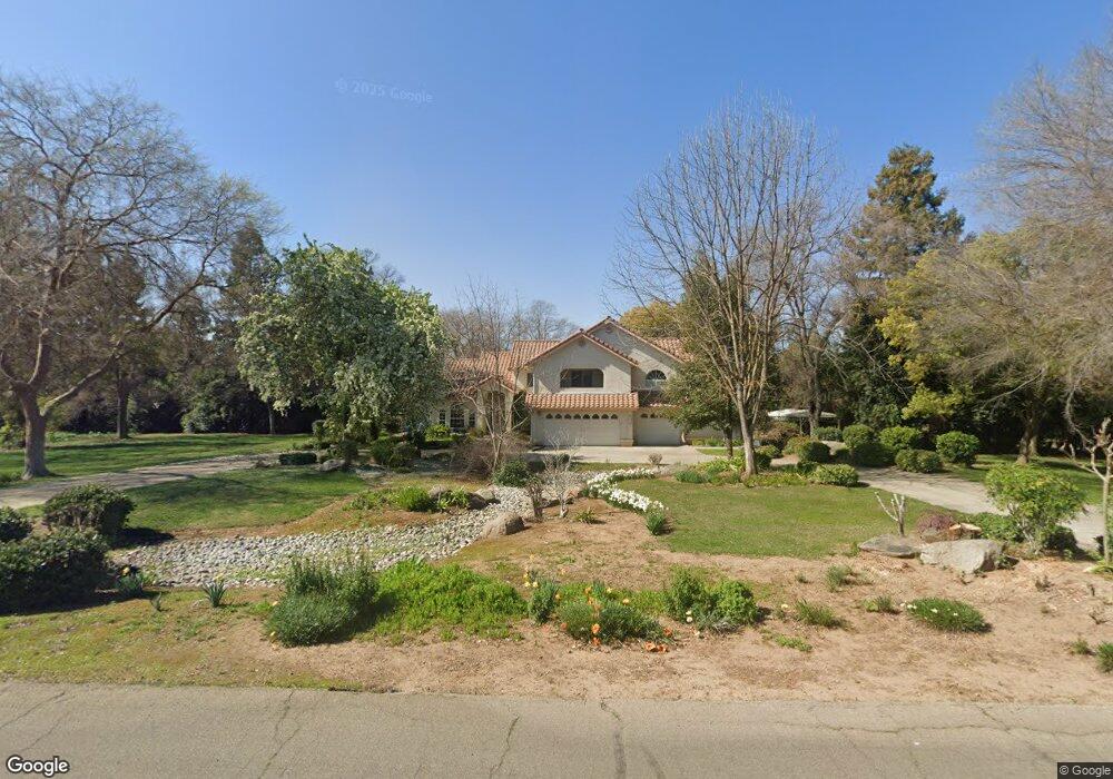
6155 Dockery Ave Clovis, CA 93619
Estimated Value: $800,000 - $1,071,000
3
Beds
4
Baths
3,030
Sq Ft
$310/Sq Ft
Est. Value
About This Home
This home is located at 6155 Dockery Ave, Clovis, CA 93619 and is currently estimated at $940,365, approximately $310 per square foot. 6155 Dockery Ave is a home located in Fresno County with nearby schools including Cedarwood Elementary School, Clark Intermediate School, and Clovis High School.
Ownership History
Date
Name
Owned For
Owner Type
Purchase Details
Closed on
Apr 11, 2000
Sold by
Goddard Katherine L and Siomiak Katherine L
Bought by
Pesl Markham A and Pesl Linda Freeman
Current Estimated Value
Home Financials for this Owner
Home Financials are based on the most recent Mortgage that was taken out on this home.
Original Mortgage
$252,700
Outstanding Balance
$86,512
Interest Rate
8.22%
Estimated Equity
$853,853
Purchase Details
Closed on
Sep 29, 1998
Sold by
Siomiak Greg F
Bought by
Goddard Katherine L
Create a Home Valuation Report for This Property
The Home Valuation Report is an in-depth analysis detailing your home's value as well as a comparison with similar homes in the area
Purchase History
| Date | Buyer | Sale Price | Title Company |
|---|---|---|---|
| Pesl Markham A | $330,000 | Financial Title Company | |
| Goddard Katherine L | -- | -- |
Source: Public Records
Mortgage History
| Date | Status | Borrower | Loan Amount |
|---|---|---|---|
| Open | Pesl Markham A | $252,700 | |
| Closed | Pesl Markham A | $60,800 |
Source: Public Records
Tax History
| Year | Tax Paid | Tax Assessment Tax Assessment Total Assessment is a certain percentage of the fair market value that is determined by local assessors to be the total taxable value of land and additions on the property. | Land | Improvement |
|---|---|---|---|---|
| 2025 | $5,891 | $507,184 | $99,892 | $407,292 |
| 2023 | $5,663 | $487,491 | $96,014 | $391,477 |
| 2022 | $5,586 | $477,933 | $94,132 | $383,801 |
| 2021 | $5,428 | $468,563 | $92,287 | $376,276 |
| 2020 | $5,406 | $463,759 | $91,341 | $372,418 |
| 2019 | $5,299 | $454,666 | $89,550 | $365,116 |
| 2018 | $5,181 | $445,752 | $87,795 | $357,957 |
| 2017 | $5,091 | $437,013 | $86,074 | $350,939 |
| 2016 | $4,916 | $428,445 | $84,387 | $344,058 |
| 2015 | $4,840 | $422,010 | $83,120 | $338,890 |
| 2014 | $4,749 | $413,744 | $81,492 | $332,252 |
Source: Public Records
Map
Nearby Homes
- 10595 E San Felipe Ave
- 11236 E Herndon Ave
- 11640 E Sierra Ave
- 9321 E Bullard Ave
- 10464 E Herndon Ave
- 10455 E Greenbury Way
- 10588 E Fieldstone Ave
- 4793 N Emerald Peak Dr
- 4769 N Emerald Peak Dr
- 4674 N Arrow Ridge Way
- 4626 N Arrow Ridge Way
- 4588 N Mccall Ave
- 6560 N Bethel Ave
- 10952 E Promontory Way
- 1437 Las Rosas Ave
- 1040 San Marino Ave
- 1006 La Canada Ave
- 637 Soledad Ave
- 4148 Beverly Ave
- 10819 E Fountain View
- 6089 Dockery Ave
- 6213 Dockery Ave
- 6142 Dockery Ave
- 6198 Dockery Ave
- 6196 Ranger Rd
- 6084 Dockery Ave
- 6250 Dockery Ave
- 6271 Dockery Ave
- 6037 Dockery Ave
- 6164 Ranger Rd
- 6132 Ranger Rd
- 10472 E Bullard Ave
- 6098 Ranger Rd
- 6230 Ranger Rd
- 10426 E Bullard Ave
- 6294 Dockery Ave
- 6267 Ranger Rd
- 6262 Ranger Rd
- 10648 E Bullard Ave
- 6319 Dockery Ave
Your Personal Tour Guide
Ask me questions while you tour the home.