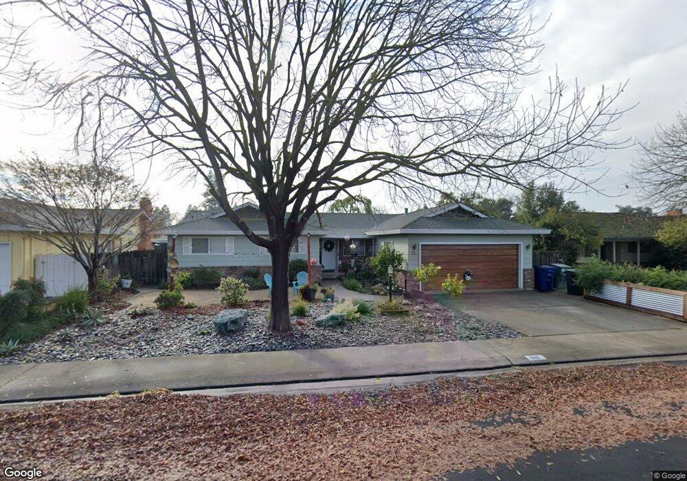
616 Mayflower St Modesto, CA 95356
Central Modesto NeighborhoodEstimated Value: $424,000 - $554,000
3
Beds
2
Baths
1,954
Sq Ft
$256/Sq Ft
Est. Value
About This Home
This home is located at 616 Mayflower St, Modesto, CA 95356 and is currently estimated at $501,182, approximately $256 per square foot. 616 Mayflower St is a home located in Stanislaus County with nearby schools including Woodrow Elementary School, Somerset Middle School, and Grace M. Davis High School.
Ownership History
Date
Name
Owned For
Owner Type
Purchase Details
Closed on
Apr 28, 2010
Sold by
Neep Robert A and Neep Kim T
Bought by
Neep Kim T
Current Estimated Value
Purchase Details
Closed on
Jan 23, 2007
Sold by
Neep Robert A and Neep Kim T
Bought by
Neep Robert A and Neep Kim T
Purchase Details
Closed on
Dec 16, 1998
Sold by
Knight Edith
Bought by
Neep Robert and Neep Kim
Create a Home Valuation Report for This Property
The Home Valuation Report is an in-depth analysis detailing your home's value as well as a comparison with similar homes in the area
Home Values in the Area
Average Home Value in this Area
Purchase History
| Date | Buyer | Sale Price | Title Company |
|---|---|---|---|
| Neep Kim T | -- | None Available | |
| Neep Robert A | -- | None Available | |
| Neep Robert | $18,500 | Fidelity National Title Co |
Source: Public Records
Tax History
| Year | Tax Paid | Tax Assessment Tax Assessment Total Assessment is a certain percentage of the fair market value that is determined by local assessors to be the total taxable value of land and additions on the property. | Land | Improvement |
|---|---|---|---|---|
| 2025 | $2,844 | $264,367 | $86,676 | $177,691 |
| 2024 | $2,791 | $259,184 | $84,977 | $174,207 |
| 2023 | $2,737 | $254,103 | $83,311 | $170,792 |
| 2022 | $2,624 | $249,122 | $81,678 | $167,444 |
| 2021 | $2,577 | $244,238 | $80,077 | $164,161 |
| 2020 | $2,539 | $241,734 | $79,256 | $162,478 |
| 2019 | $2,491 | $236,995 | $77,702 | $159,293 |
| 2018 | $2,441 | $232,349 | $76,179 | $156,170 |
| 2017 | $2,381 | $227,794 | $74,686 | $153,108 |
| 2016 | $2,366 | $223,328 | $73,222 | $150,106 |
| 2015 | $2,330 | $219,975 | $72,123 | $147,852 |
| 2014 | $2,320 | $215,667 | $70,711 | $144,956 |
Source: Public Records
Map
Nearby Homes
- 3724 Columbine Dr
- 3721 Marigold Ln
- 3800 Marigold Ln
- 3600 Columbine Dr Unit 6
- 3804 Semallon Dr
- 3909 Trillium Ave
- 3728 Fuchsia Ln
- 325 Standiford Ave Unit 29
- 325 Standiford Ave Unit 52
- 904 W Union Ave
- 413 Redford Ln
- 3913 Cougar Place
- 3417 John Lee Ln
- 3312 Whitehorse Ave
- 3325 Sherwood Ave
- 920 Kevin Ct
- 3432 Colonial Dr
- 3632 Busher Ct
- 917 Woodrow Ave
- 3313 Colonial Dr
Your Personal Tour Guide
Ask me questions while you tour the home.