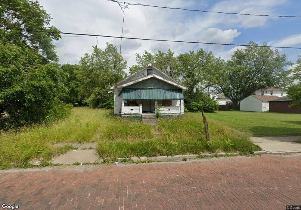
618 Brown Ave Toledo, OH 43607
ONYX NeighborhoodEstimated Value: $50,000 - $64,026
3
Beds
1
Bath
912
Sq Ft
$63/Sq Ft
Est. Value
About This Home
This home is located at 618 Brown Ave, Toledo, OH 43607 and is currently estimated at $57,757, approximately $63 per square foot. 618 Brown Ave is a home located in Lucas County with nearby schools including Pickett Elementary School, Jesup W. Scott High School, and Explorers Academy.
Ownership History
Date
Name
Owned For
Owner Type
Purchase Details
Closed on
Apr 10, 2012
Sold by
Rixey William and Rixey William W
Bought by
Bennett Ralph
Current Estimated Value
Purchase Details
Closed on
Sep 12, 2003
Sold by
Rixey William
Bought by
Phillips Kevin and Anderson Crystal
Purchase Details
Closed on
Nov 2, 2000
Sold by
Hud
Bought by
Rixey William W
Home Financials for this Owner
Home Financials are based on the most recent Mortgage that was taken out on this home.
Original Mortgage
$28,000
Interest Rate
7.86%
Purchase Details
Closed on
May 30, 2000
Sold by
Johnson Kenneth D
Bought by
Hud
Create a Home Valuation Report for This Property
The Home Valuation Report is an in-depth analysis detailing your home's value as well as a comparison with similar homes in the area
Home Values in the Area
Average Home Value in this Area
Purchase History
| Date | Buyer | Sale Price | Title Company |
|---|---|---|---|
| Bennett Ralph | $1,600 | None Available | |
| Phillips Kevin | $2,200 | -- | |
| Rixey William W | $4,800 | Prospect Title Agency Inc | |
| Hud | $13,000 | -- |
Source: Public Records
Mortgage History
| Date | Status | Borrower | Loan Amount |
|---|---|---|---|
| Previous Owner | Rixey William W | $28,000 |
Source: Public Records
Tax History Compared to Growth
Tax History
| Year | Tax Paid | Tax Assessment Tax Assessment Total Assessment is a certain percentage of the fair market value that is determined by local assessors to be the total taxable value of land and additions on the property. | Land | Improvement |
|---|---|---|---|---|
| 2024 | $9,248 | $5,075 | $1,225 | $3,850 |
| 2023 | $866 | $5,215 | $1,050 | $4,165 |
| 2022 | $603 | $5,215 | $1,050 | $4,165 |
| 2021 | $492 | $5,215 | $1,050 | $4,165 |
| 2020 | $514 | $4,795 | $1,015 | $3,780 |
| 2019 | $508 | $4,795 | $1,015 | $3,780 |
| 2018 | $477 | $4,795 | $1,015 | $3,780 |
| 2017 | $1,347 | $4,095 | $980 | $3,115 |
| 2016 | $737 | $11,700 | $2,800 | $8,900 |
| 2015 | $462 | $11,700 | $2,800 | $8,900 |
| 2014 | $387 | $4,100 | $980 | $3,120 |
| 2013 | $258 | $4,100 | $980 | $3,120 |
Source: Public Records
Map
Nearby Homes
- 605 Waverly Ave
- 721 N Detroit Ave
- 1532 Nebraska Ave
- 1557 Indiana Ave
- 323 Pulaski St
- 834 N Detroit Ave
- 1434 Nebraska Ave
- 1131 Montrose Ave
- 1534 Indiana Ave
- 1422 Tecumseh St
- 1215 Woodstock Ave
- 1318 Addington Rd
- 2033 Crosswell Place
- 1940 Crosswell Place
- 908 Coventry Ave
- 1907 Fernwood Ave
- 1273 Nebraska Ave
- 1267 Nebraska Ave
- 2145 Dorr St
- 913 Coventry Ave
- 616 Brown Ave
- 610 Brown Ave
- 1688 Nebraska Ave
- 1698 Nebraska Ave
- 1684 Nebraska Ave
- 1678 Nebraska Ave
- 1676 Nebraska Ave
- 1717 Vance St
- 1711 Vance St
- 1705 Vance St
- 1689 Nebraska Ave
- 1707 Vance St
- 1701 Vance St
- 1674 Nebraska Ave
- 1672 Nebraska Ave
- 1687 Nebraska Ave
- 1697 Vance St
- 1685 Nebraska Ave
- 1670 Nebraska Ave
- 1681 Nebraska Ave