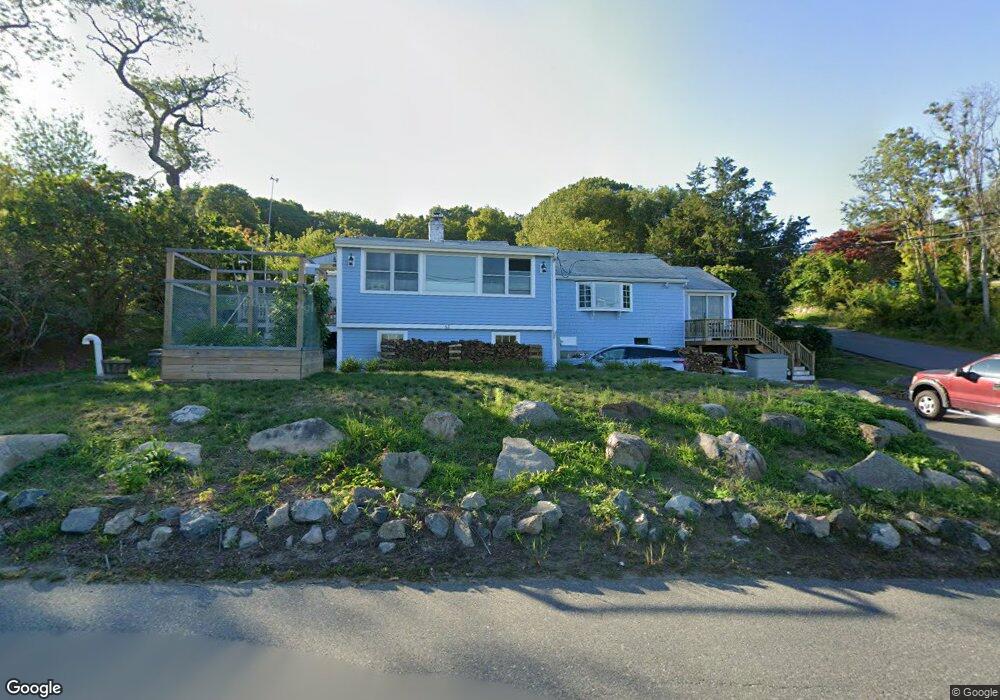
62 Atlantic St Gloucester, MA 01930
West Gloucester NeighborhoodEstimated Value: $646,000 - $821,000
2
Beds
3
Baths
1,326
Sq Ft
$540/Sq Ft
Est. Value
About This Home
This home is located at 62 Atlantic St, Gloucester, MA 01930 and is currently estimated at $715,870, approximately $539 per square foot. 62 Atlantic St is a home located in Essex County with nearby schools including West Parish, Ralph B O'maley Middle School, and Gloucester High School.
Ownership History
Date
Name
Owned For
Owner Type
Purchase Details
Closed on
Oct 28, 2025
Sold by
Reynolds Pamela D
Bought by
Pamela D Reynolds Irt and Reynolds
Current Estimated Value
Home Financials for this Owner
Home Financials are based on the most recent Mortgage that was taken out on this home.
Original Mortgage
$142,272
Outstanding Balance
$142,272
Interest Rate
6.35%
Mortgage Type
Purchase Money Mortgage
Estimated Equity
$573,598
Purchase Details
Closed on
Oct 31, 1995
Sold by
Scott Catherine M and Scott Keith C
Bought by
Rickman Peter
Home Financials for this Owner
Home Financials are based on the most recent Mortgage that was taken out on this home.
Original Mortgage
$114,000
Interest Rate
7.6%
Mortgage Type
Purchase Money Mortgage
Purchase Details
Closed on
Jul 9, 1993
Sold by
Louise M Monaghan Est and Bagshaw
Bought by
Scott Keith C and Scott Catherine
Create a Home Valuation Report for This Property
The Home Valuation Report is an in-depth analysis detailing your home's value as well as a comparison with similar homes in the area
Home Values in the Area
Average Home Value in this Area
Purchase History
| Date | Buyer | Sale Price | Title Company |
|---|---|---|---|
| Pamela D Reynolds Irt | -- | -- | |
| Rickman Peter | $142,500 | -- | |
| Scott Keith C | $139,900 | -- |
Source: Public Records
Mortgage History
| Date | Status | Borrower | Loan Amount |
|---|---|---|---|
| Open | Pamela D Reynolds Irt | $142,272 | |
| Previous Owner | Scott Keith C | $74,000 | |
| Previous Owner | Scott Keith C | $75,000 | |
| Previous Owner | Scott Keith C | $114,000 | |
| Previous Owner | Scott Keith C | $68,000 |
Source: Public Records
Tax History
| Year | Tax Paid | Tax Assessment Tax Assessment Total Assessment is a certain percentage of the fair market value that is determined by local assessors to be the total taxable value of land and additions on the property. | Land | Improvement |
|---|---|---|---|---|
| 2025 | $4,710 | $484,600 | $197,100 | $287,500 |
| 2024 | $4,581 | $470,800 | $187,700 | $283,100 |
| 2023 | $4,597 | $434,100 | $167,600 | $266,500 |
| 2022 | $4,357 | $371,400 | $145,800 | $225,600 |
| 2021 | $4,373 | $351,500 | $132,500 | $219,000 |
| 2020 | $4,102 | $332,700 | $132,500 | $200,200 |
| 2019 | $4,084 | $321,800 | $132,500 | $189,300 |
| 2018 | $4,047 | $313,000 | $132,500 | $180,500 |
| 2017 | $3,942 | $298,900 | $126,200 | $172,700 |
| 2016 | $3,828 | $281,300 | $131,800 | $149,500 |
| 2015 | $3,780 | $276,900 | $131,800 | $145,100 |
Source: Public Records
Map
Nearby Homes
- 167 Atlantic St
- 178 Atlantic St
- 13 Honeysuckle Rd
- 226 Atlantic St
- 2 Breezy Point Rd
- 5 Samoset Rd Unit B
- 3 Deacon Farm Ln
- 7 Leaman Dr
- 368 Essex Ave
- 31 Echo Ave
- 24 Cobblestone Ln Unit 603
- 5 Lepage Ln
- 145 Essex Ave Unit 402
- 672 Washington St
- 3 Rockland St
- 6 Monroe Ct
- 13 Mystic Ave
- 8 Mystic Ave
- 15 Lufkin Point Rd
- 15 Harvard St
Your Personal Tour Guide
Ask me questions while you tour the home.