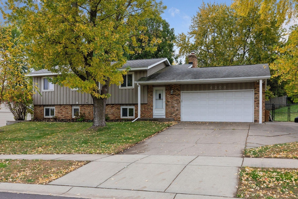
6200 132nd Way Saint Paul, MN 55124
Scott Highlands NeighborhoodEstimated payment $2,549/month
Highlights
- Deck
- Corner Lot
- Double Oven
- Greenleaf Elementary School Rated 9+
- No HOA
- 2 Car Attached Garage
About This Home
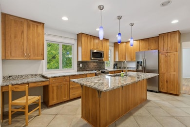
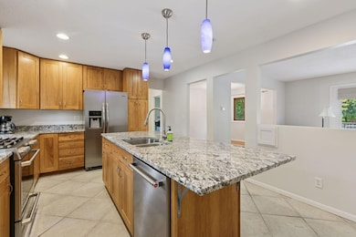
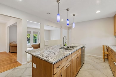
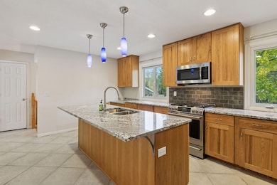
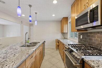
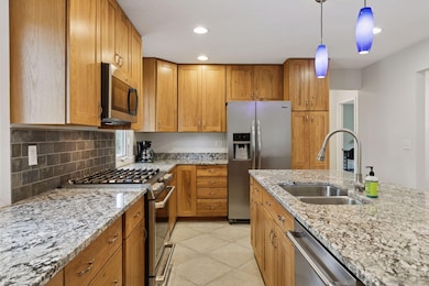
Wonderful opportunity to own a spacious split-foyer home in the highly sought-after Greenleaf neighborhood of Apple Valley! Located within the award-winning Eastview High, Falcon Ridge Middle, and Greenleaf Elementary school boundaries, this home offers 4 bedrooms, 2 baths, and an inviting open layout filled with natural light. The stunning kitchen features rich Hickory-style cabinetry with soft-close doors and drawers, stainless steel appliances, and an oversized center island with pendant lighting—perfect for the home chef and entertaining alike. Gleaming hardwood floors flow through the living and dining areas, where a large patio door opens to an expansive 18x18 maintenance-free deck overlooking the private, fenced 1/3-acre corner lot. The lower level includes a spacious family room with a cozy wood-burning fireplace, two additional bedrooms, a 3⁄4 bath, and a bright laundry/utility room. Recent updates include a new HVAC system (2025), Composite 18x18 deck and a Timberline-style roof. Move-in ready and beautifully maintained—this one won’t last!
Home Details
Home Type
- Single Family
Est. Annual Taxes
- $4,154
Year Built
- Built in 1972
Lot Details
- 0.34 Acre Lot
- Lot Dimensions are 114 x 137 x 99 x 140
- Chain Link Fence
- Corner Lot
- Many Trees
Parking
- 2 Car Attached Garage
Home Design
- Bi-Level Home
- Brick Veneer
- Wood Siding
Interior Spaces
- Pendant Lighting
- Fireplace Features Masonry
- Family Room with Fireplace
- Living Room
- Dining Room
- Utility Room
Kitchen
- Double Oven
- Range
- Microwave
- Dishwasher
Bedrooms and Bathrooms
- 4 Bedrooms
Laundry
- Laundry Room
- Dryer
Finished Basement
- Drainage System
- Drain
- Block Basement Construction
- Natural lighting in basement
Outdoor Features
- Deck
- Patio
Utilities
- Forced Air Heating and Cooling System
- Humidifier
- Vented Exhaust Fan
- 100 Amp Service
- Gas Water Heater
- Water Softener is Owned
Community Details
- No Home Owners Association
- Greenleaf 4Th Add Subdivision
Listing and Financial Details
- Assessor Parcel Number 013100314120
Map
Home Values in the Area
Average Home Value in this Area
Tax History
| Year | Tax Paid | Tax Assessment Tax Assessment Total Assessment is a certain percentage of the fair market value that is determined by local assessors to be the total taxable value of land and additions on the property. | Land | Improvement |
|---|---|---|---|---|
| 2024 | $4,262 | $363,200 | $105,900 | $257,300 |
| 2023 | $3,892 | $377,900 | $106,100 | $271,800 |
| 2022 | $3,646 | $368,700 | $105,800 | $262,900 |
| 2021 | $3,458 | $319,200 | $92,000 | $227,200 |
| 2020 | $3,490 | $297,800 | $87,600 | $210,200 |
| 2019 | $3,182 | $291,900 | $83,400 | $208,500 |
| 2018 | $2,991 | $279,600 | $79,500 | $200,100 |
| 2017 | $2,930 | $253,800 | $75,700 | $178,100 |
| 2016 | $2,902 | $237,600 | $72,100 | $165,500 |
| 2015 | $2,771 | $216,839 | $65,768 | $151,071 |
| 2014 | -- | $208,446 | $62,978 | $145,468 |
| 2013 | -- | $188,935 | $57,363 | $131,572 |
Property History
| Date | Event | Price | List to Sale | Price per Sq Ft |
|---|---|---|---|---|
| 10/23/2025 10/23/25 | For Sale | $420,000 | -- | $209 / Sq Ft |
Purchase History
| Date | Type | Sale Price | Title Company |
|---|---|---|---|
| Warranty Deed | $272,000 | Edina Realty Title Inc | |
| Warranty Deed | $165,700 | -- | |
| Warranty Deed | $118,500 | -- |
Source: NorthstarMLS
MLS Number: 6808295
APN: 01-31003-14-120
Disclaimer: Certain information contained herein is derived from information provided by parties other than Homes.com. All information provided is deemed reliable, but is not guaranteed to be accurate and should be independently verified.
![]() Based on information submitted to the MLS GRID. All data is obtained from various sources and may not have been verified by broker or MLS GRID. Supplied Open House Information is subject to change without notice. All information should be independently reviewed and verified for accuracy. Properties may or may not be listed by the office/agent presenting the information. Some IDX listings have been excluded from this website.
Based on information submitted to the MLS GRID. All data is obtained from various sources and may not have been verified by broker or MLS GRID. Supplied Open House Information is subject to change without notice. All information should be independently reviewed and verified for accuracy. Properties may or may not be listed by the office/agent presenting the information. Some IDX listings have been excluded from this website.
The Digital Millennium Copyright Act of 1998, 17 U.S.C. § 512 (the “DMCA”) provides recourse for copyright owners who believe that material appearing on the Internet infringes their rights under U.S. copyright law. If you believe in good faith that any content or material made available in connection with our website or services infringes your copyright, you (or your agent) may send us a notice requesting that the content or material be removed, or access to it blocked.
Notices must be sent in writing by email to DMCAnotice@MLSGrid.com.
The DMCA requires that your notice of alleged copyright infringement include the following information:
(1) description of the copyrighted work that is the subject of claimed infringement;
(2) description of the alleged infringing content and information sufficient to permit us to locate the content;
(3) contact information for you, including your address, telephone number and email address;
(4) a statement by you that you have a good faith belief that the content in the manner complained of is not authorized by the copyright owner, or its agent, or by the operation of any law;
(5) a statement by you, signed under penalty of perjury, that the information in the notification is accurate and that you have the authority to enforce the copyrights that are claimed to be infringed; and
(6) a physical or electronic signature of the copyright owner or a person authorized to act on the copyright owner’s behalf. Failure to include all of the above information may result in the delay of the processing of your complaint.
- 13018 Findlay Ave
- 6567 133rd St W
- 13573 Everton Ave
- 13641 Everton Ave
- 13912 Farmington Way
- 13973 Falcon Ave
- 12865 Foliage Ave
- 13947 Fleetwood Ave
- 13135 Gamma Way
- 14057 Flintwood Ct
- 13169X Diamond Path
- 14115 Foxtail Ln
- 13937 Ember Ct
- 13150 Elderberry Ct
- 13158 Galleria Place
- 12785 Edinbrook Path
- 13008 Echo Ln
- 13877 Elkhart Rd
- 12710 Granger Ct Unit 323
- 14126 141st St W
- 14217 Footbridge Way
- 12790 Germane Ave
- 12655 Garner Way Unit 50
- 5520 W 142nd St W
- 7126 123rd St W Unit 353
- 7433 128th St W
- 12685 Germane Ave
- 14260 Empire Ave
- 7440 Germane Trail Unit TOWNHOUSE end unit
- 7405 W 123rd St
- 14650 Foliage Ave
- 12555 Pennock Ave
- 14191 Pennock Ave
- 6859 152nd St W
- 13685 Harwell Path
- 2202 Marilyn Ave
- 6780 Fortino St
- 15283 Galante Ln
- 8331 Upper 138th Ct
- 15430 Founders Ln
