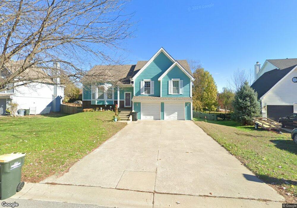
621 Bittersweet Rd Lansing, KS 66043
Estimated Value: $330,947 - $379,000
4
Beds
3
Baths
1,579
Sq Ft
$223/Sq Ft
Est. Value
About This Home
This home is located at 621 Bittersweet Rd, Lansing, KS 66043 and is currently estimated at $351,987, approximately $222 per square foot. 621 Bittersweet Rd is a home located in Leavenworth County with nearby schools including Lansing Elementary School, Lansing Middle 6-8, and Lansing High 9-12.
Ownership History
Date
Name
Owned For
Owner Type
Purchase Details
Closed on
Mar 9, 2009
Sold by
Geans Reginald A and Geans Jamie
Bought by
Patrie Larry J and Patrie Christina U
Current Estimated Value
Home Financials for this Owner
Home Financials are based on the most recent Mortgage that was taken out on this home.
Original Mortgage
$88,000
Outstanding Balance
$55,956
Interest Rate
5.13%
Mortgage Type
VA
Estimated Equity
$296,031
Create a Home Valuation Report for This Property
The Home Valuation Report is an in-depth analysis detailing your home's value as well as a comparison with similar homes in the area
Home Values in the Area
Average Home Value in this Area
Purchase History
| Date | Buyer | Sale Price | Title Company |
|---|---|---|---|
| Patrie Larry J | $86,240 | Tri-County Title & Abstract Ll |
Source: Public Records
Mortgage History
| Date | Status | Borrower | Loan Amount |
|---|---|---|---|
| Open | Patrie Larry J | $88,000 |
Source: Public Records
Tax History
| Year | Tax Paid | Tax Assessment Tax Assessment Total Assessment is a certain percentage of the fair market value that is determined by local assessors to be the total taxable value of land and additions on the property. | Land | Improvement |
|---|---|---|---|---|
| 2025 | $4,365 | $35,581 | $5,499 | $30,082 |
| 2024 | $4,365 | $34,213 | $4,338 | $29,875 |
| 2023 | $4,365 | $33,661 | $4,338 | $29,323 |
| 2022 | $3,803 | $30,245 | $3,297 | $26,948 |
| 2021 | $3,803 | $26,450 | $3,297 | $23,153 |
| 2020 | $3,546 | $24,288 | $3,297 | $20,991 |
| 2019 | $3,551 | $24,288 | $3,297 | $20,991 |
| 2018 | $3,267 | $22,379 | $2,712 | $19,667 |
| 2017 | $3,274 | $22,379 | $2,712 | $19,667 |
| 2016 | $3,276 | $22,379 | $2,712 | $19,667 |
| 2015 | $3,266 | $22,379 | $2,712 | $19,667 |
| 2014 | $3,199 | $22,379 | $2,712 | $19,667 |
Source: Public Records
Map
Nearby Homes
- 922 Southfork St
- 811 4-H Rd
- 503 S 1st St
- 202 S Main St
- 124 S Main St
- 26731 147th St
- 111 Southfork Rd
- 215 E Mary St
- 20958 Ida St
- 218 E Kay St
- 875 Clearview Dr
- 189 Canyon View Dr
- 1221 S Desoto Rd
- 1322 Rock Creek Ct
- 712 Rock Creek Dr
- 898 Clearview Dr
- 00000 Brookwood St
- 1313 Stone Ln
- 530 Holiday Ct
- 950 Holiday Dr
- 619 Bittersweet Rd
- 625 S Bittersweet Ln
- 625 Bittersweet Rd
- 827 Blueberry St
- 613 Bittersweet Rd
- 829 Blueberry St
- 613 S Bittersweet Ln
- 825 Blueberry St
- 620 Bittersweet Rd
- 831 Blueberry St
- 624 Bittersweet Rd
- 618 Bittersweet Rd
- 611 Bittersweet Rd
- 823 Blueberry St
- 701 Bittersweet Rd
- 614 Bittersweet Rd
- 00000 Maple Ln
- 700 Bittersweet Rd
- 607 Bittersweet Rd
- 821 Blueberry St
Your Personal Tour Guide
Ask me questions while you tour the home.