Estimated Value: $241,639 - $258,000
3
Beds
2
Baths
1,150
Sq Ft
$217/Sq Ft
Est. Value
About This Home
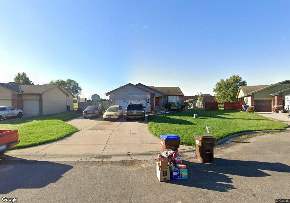
This home is located at 621 Laramie Cir, Maize, KS 67101 and is currently estimated at $249,820, approximately $217 per square foot. 621 Laramie Cir is a home located in Sedgwick County with nearby schools including Maize Middle School and Maize High School.
Ownership History
Date
Name
Owned For
Owner Type
Purchase Details
Closed on
Nov 5, 2014
Sold by
Lies Lexi M and Lies Jordan
Bought by
Garcia Payl Frederick and Blanding Garcia Joni Marie
Current Estimated Value
Purchase Details
Closed on
Jun 5, 2010
Sold by
Garcia Lexi M
Bought by
Garcia Lexi M and Blanding Garcia Joni Marie
Purchase Details
Closed on
Sep 2, 2009
Sold by
Dannunzio Jenni and Dannunzio Jennifer
Bought by
Garcia Lexi M
Home Financials for this Owner
Home Financials are based on the most recent Mortgage that was taken out on this home.
Original Mortgage
$89,600
Outstanding Balance
$58,509
Interest Rate
5.16%
Mortgage Type
Future Advance Clause Open End Mortgage
Estimated Equity
$191,311
Create a Home Valuation Report for This Property
The Home Valuation Report is an in-depth analysis detailing your home's value as well as a comparison with similar homes in the area
Home Values in the Area
Average Home Value in this Area
Purchase History
| Date | Buyer | Sale Price | Title Company |
|---|---|---|---|
| Garcia Payl Frederick | -- | None Available | |
| Garcia Lexi M | -- | None Available | |
| Garcia Lexi M | -- | 1St Am |
Source: Public Records
Mortgage History
| Date | Status | Borrower | Loan Amount |
|---|---|---|---|
| Open | Garcia Lexi M | $89,600 |
Source: Public Records
Tax History
| Year | Tax Paid | Tax Assessment Tax Assessment Total Assessment is a certain percentage of the fair market value that is determined by local assessors to be the total taxable value of land and additions on the property. | Land | Improvement |
|---|---|---|---|---|
| 2025 | $3,373 | $24,035 | $5,658 | $18,377 |
| 2023 | $3,373 | $21,138 | $4,359 | $16,779 |
| 2022 | $2,850 | $18,941 | $4,106 | $14,835 |
| 2021 | $2,640 | $17,377 | $2,841 | $14,536 |
| 2020 | $2,483 | $16,388 | $2,841 | $13,547 |
| 2019 | $2,314 | $15,319 | $2,841 | $12,478 |
| 2018 | $2,189 | $14,456 | $2,243 | $12,213 |
| 2017 | $2,115 | $0 | $0 | $0 |
| 2016 | $2,708 | $0 | $0 | $0 |
| 2015 | $2,785 | $0 | $0 | $0 |
| 2014 | $2,791 | $0 | $0 | $0 |
Source: Public Records
Map
Nearby Homes
- 600 Laramie Cir
- 713 High Plains Cir
- 721 High Plains Cir
- 4727 Rose Ann Ct
- 652 Plantation Rd
- 613 S Sweetwater Cir
- 403 S Sweetwater Rd
- 9658 W Cedar Ln
- 415 S Sweetwater Rd
- 9657 W Cedar Ln
- 429 S Longbranch Dr
- 9646 W Cedar Ln
- 9642 W Cedar Ln
- 9638 W Cedar Ln
- 9630 W Cedar Ln
- 9650 W Cedar Ln
- 9637 W Cedar Ln
- 600 Trotter Ave
- 4456 N Bluestem St
- 10498 W Wilkinson St
- 627 Laramie Cir
- 615 Laramie Cir
- 635 Laramie Cir
- 614 Laramie Cir
- 624 Laramie Cir
- 611 Laramie Cir
- 707 Laramie Cir
- 638 Laramie Cir
- 700 Laramie Cir
- 715 Laramie Cir
- 637 High Plains Cir
- 714 Laramie Cir
- 629 High Plains Cir
- 621 High Plains Cir
- 721 Laramie Cir
- 615 High Plains Cir
- 643 High Plains Cir
- 705 High Plains Cir
- 611 High Plains Cir
- 722 Laramie Cir
Your Personal Tour Guide
Ask me questions while you tour the home.