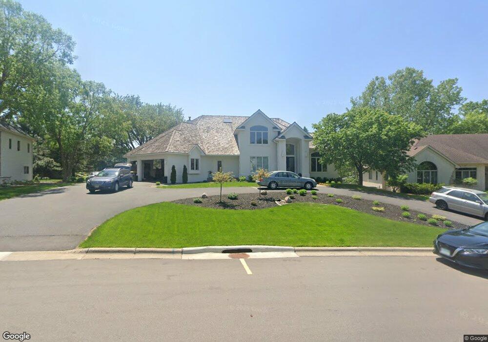
622 Sutcliff Cir Saint Paul, MN 55118
Estimated Value: $842,000 - $1,122,337
4
Beds
4
Baths
5,708
Sq Ft
$165/Sq Ft
Est. Value
About This Home
This home is located at 622 Sutcliff Cir, Saint Paul, MN 55118 and is currently estimated at $940,834, approximately $164 per square foot. 622 Sutcliff Cir is a home located in Dakota County with nearby schools including Somerset Elementary School, Heritage E-STEM Magnet School, and Two Rivers High School.
Ownership History
Date
Name
Owned For
Owner Type
Purchase Details
Closed on
Jun 25, 2021
Sold by
Sargent Michael M and Sargent Katherine M
Bought by
Sargent Michael M and Sargent Katherine M
Current Estimated Value
Purchase Details
Closed on
Nov 18, 2019
Sold by
Krause Steve I and Krause Marjorie A
Bought by
Sargent Michael M and Eichenberg Katherine M
Create a Home Valuation Report for This Property
The Home Valuation Report is an in-depth analysis detailing your home's value as well as a comparison with similar homes in the area
Home Values in the Area
Average Home Value in this Area
Purchase History
| Date | Buyer | Sale Price | Title Company |
|---|---|---|---|
| Sargent Michael M | -- | None Available | |
| Sargent Michael M | $605,000 | Dca Title |
Source: Public Records
Tax History Compared to Growth
Tax History
| Year | Tax Paid | Tax Assessment Tax Assessment Total Assessment is a certain percentage of the fair market value that is determined by local assessors to be the total taxable value of land and additions on the property. | Land | Improvement |
|---|---|---|---|---|
| 2024 | $9,996 | $951,800 | $180,900 | $770,900 |
| 2023 | $9,996 | $915,600 | $176,800 | $738,800 |
| 2022 | $9,446 | $919,800 | $176,400 | $743,400 |
| 2021 | $8,686 | $804,400 | $153,400 | $651,000 |
| 2020 | $8,092 | $794,600 | $146,100 | $648,500 |
| 2019 | $7,755 | $722,700 | $139,100 | $583,600 |
| 2018 | $7,427 | $665,500 | $130,000 | $535,500 |
| 2017 | $7,399 | $661,900 | $123,800 | $538,100 |
| 2016 | $7,436 | $640,300 | $117,900 | $522,400 |
| 2015 | $7,028 | $648,200 | $110,400 | $537,800 |
| 2014 | -- | $598,100 | $104,200 | $493,900 |
| 2013 | -- | $562,600 | $101,100 | $461,500 |
Source: Public Records
Map
Nearby Homes
- 606 Sutcliff Cir
- 641 Sibley Memorial Hwy
- 1000 Winston Cir
- 967 Cherokee Ave
- 955 Cherokee Ave
- 1174 Dodd Rd
- 1164 Dodd Rd
- 679 Maple Park Dr
- 625 Ivy Falls Ave
- 8 Dorset Rd
- 672 Ivy Falls Ct
- 801 Cherokee Ave
- 1172 Ottawa Ave
- 648 Sunset Ln
- 750 Delaware Ave
- 13XX Clement St
- 822 Smith Ave S
- 751 Butternut Ave
- 663 Smith Ave S
- 242 Annapolis St W
- 614 Sutcliff Cir
- 630 Sutcliff Cir
- 613 Winston Ct
- 623 Sutcliff Cir
- 1000 Downing St
- 995 Winston Cir
- 994 Downing St
- 613 Sutcliff Cir
- 990 Downing St
- 990 Winston Cir
- 605 Winston Ct
- 605 Sutcliff Cir
- 596 Sutcliff Cir
- 635 Sibley Memorial Hwy
- 588 Sutcliff Cir
- 1006 Downing St
- 597 Sutcliff Cir
- 993 Downing St
- 1001 Downing St
- 994 Winston Cir