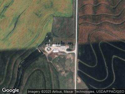
62238 280th St Malvern, IA 51551
Estimated Value: $413,000 - $543,914
3
Beds
2
Baths
1,680
Sq Ft
$285/Sq Ft
Est. Value
About This Home
This home is located at 62238 280th St, Malvern, IA 51551 and is currently estimated at $477,979, approximately $284 per square foot. 62238 280th St is a home located in Mills County with nearby schools including Fremont-Mills Elementary School and Fremont-Mills Junior/Senior High School.
Ownership History
Date
Name
Owned For
Owner Type
Purchase Details
Closed on
Apr 29, 2024
Sold by
Goodman David S and Goodman Julia C
Bought by
Dave And Julie Goodman Revocable Living Trust and Goodman
Current Estimated Value
Purchase Details
Closed on
Jun 20, 2012
Sold by
Morrical Dan R and Morrical Paul J
Bought by
Goodman David S and Goodman Julia C
Home Financials for this Owner
Home Financials are based on the most recent Mortgage that was taken out on this home.
Original Mortgage
$350,000
Interest Rate
3.07%
Mortgage Type
Future Advance Clause Open End Mortgage
Create a Home Valuation Report for This Property
The Home Valuation Report is an in-depth analysis detailing your home's value as well as a comparison with similar homes in the area
Home Values in the Area
Average Home Value in this Area
Purchase History
| Date | Buyer | Sale Price | Title Company |
|---|---|---|---|
| Dave And Julie Goodman Revocable Living Trust | -- | None Listed On Document | |
| Goodman David S | $250,000 | None Available |
Source: Public Records
Mortgage History
| Date | Status | Borrower | Loan Amount |
|---|---|---|---|
| Previous Owner | Goodman David S | $350,000 | |
| Previous Owner | Goodman David S | $306,000 | |
| Previous Owner | Goodman David S | $300,000 | |
| Previous Owner | Goodman David S | $1,000,000 |
Source: Public Records
Tax History Compared to Growth
Tax History
| Year | Tax Paid | Tax Assessment Tax Assessment Total Assessment is a certain percentage of the fair market value that is determined by local assessors to be the total taxable value of land and additions on the property. | Land | Improvement |
|---|---|---|---|---|
| 2024 | $5,230 | $423,291 | $74,014 | $349,277 |
| 2023 | $5,308 | $383,377 | $74,014 | $309,363 |
| 2022 | $5,044 | $299,700 | $53,064 | $246,636 |
| 2021 | $4,967 | $306,453 | $59,817 | $246,636 |
| 2020 | $4,956 | $283,876 | $61,160 | $222,716 |
| 2019 | $4,441 | $311,435 | $0 | $0 |
| 2018 | $3,813 | $267,211 | $0 | $0 |
| 2017 | $3,715 | $289,551 | $0 | $0 |
| 2016 | $3,410 | $289,551 | $0 | $0 |
| 2015 | $3,458 | $306,598 | $0 | $0 |
| 2014 | $3,334 | $306,598 | $0 | $0 |
Source: Public Records
Map
Nearby Homes
- 25403 Noyes Ave
- 25999 Kane Ave
- 62566 250th St
- 63189 250th St
- 60321 Jabber Rd
- 0 Paddock Ave Unit NOC6326849
- 63944 310th St
- 216 St Andrews Loop
- 216 Saint Andrews Loop
- 203 1/2 Prospect Ave
- 509 Main St
- 710 2nd Ave
- 59659 315th St
- 910 Prospect Ave
- 307 E 6th St
- 802 Marion Ave
- 501 E 10th St
- 32164 Lambert Ave
- 8+/- ACRES Ivory Rd
- 24699 Rains Ave
