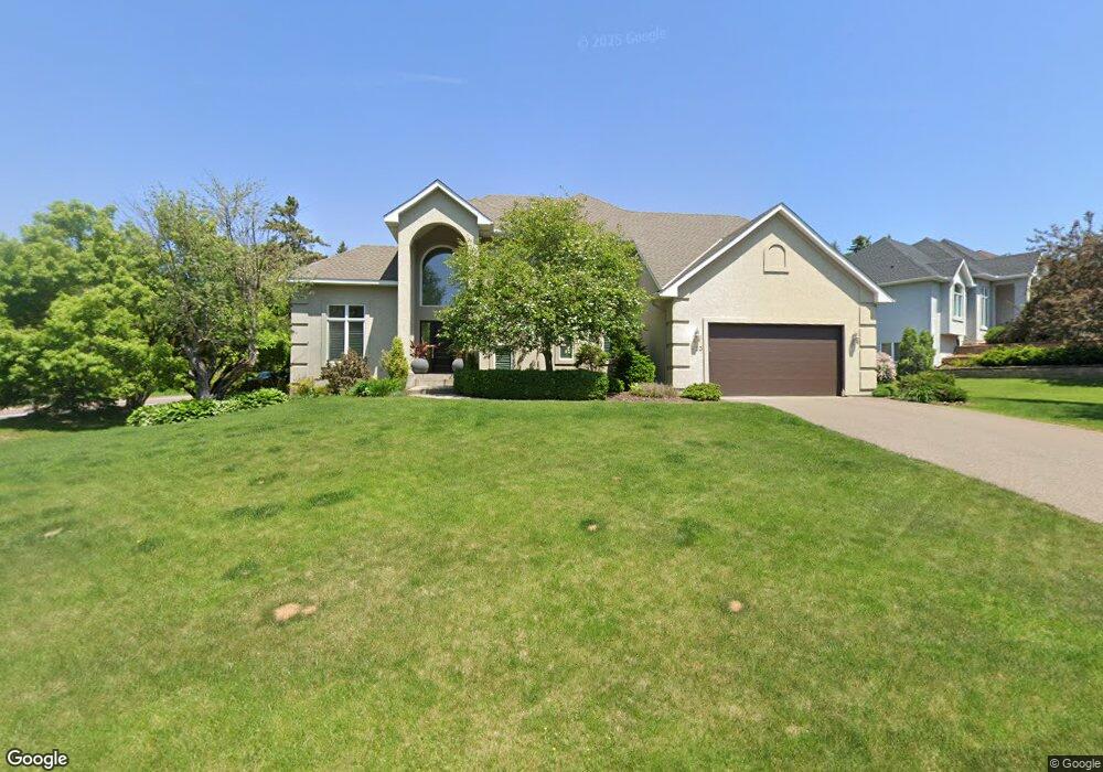
623 Sutcliff Cir Saint Paul, MN 55118
Estimated Value: $694,422 - $807,000
4
Beds
4
Baths
2,391
Sq Ft
$314/Sq Ft
Est. Value
About This Home
This home is located at 623 Sutcliff Cir, Saint Paul, MN 55118 and is currently estimated at $750,106, approximately $313 per square foot. 623 Sutcliff Cir is a home located in Dakota County with nearby schools including Somerset Elementary School, Heritage E-STEM Magnet School, and Two Rivers High School.
Ownership History
Date
Name
Owned For
Owner Type
Purchase Details
Closed on
Jan 18, 2019
Sold by
Fichtel Timothy N and Fichtel Jean A
Bought by
Fichtel Rebecca and Johnson Matthew
Current Estimated Value
Home Financials for this Owner
Home Financials are based on the most recent Mortgage that was taken out on this home.
Original Mortgage
$464,000
Outstanding Balance
$407,951
Interest Rate
4.6%
Mortgage Type
New Conventional
Estimated Equity
$342,155
Create a Home Valuation Report for This Property
The Home Valuation Report is an in-depth analysis detailing your home's value as well as a comparison with similar homes in the area
Home Values in the Area
Average Home Value in this Area
Purchase History
| Date | Buyer | Sale Price | Title Company |
|---|---|---|---|
| Fichtel Rebecca | $5,800 | Stewart Title Company |
Source: Public Records
Mortgage History
| Date | Status | Borrower | Loan Amount |
|---|---|---|---|
| Open | Fichtel Rebecca | $464,000 |
Source: Public Records
Tax History Compared to Growth
Tax History
| Year | Tax Paid | Tax Assessment Tax Assessment Total Assessment is a certain percentage of the fair market value that is determined by local assessors to be the total taxable value of land and additions on the property. | Land | Improvement |
|---|---|---|---|---|
| 2024 | $7,230 | $682,400 | $179,000 | $503,400 |
| 2023 | $7,230 | $668,600 | $174,900 | $493,700 |
| 2022 | $6,718 | $667,200 | $174,500 | $492,700 |
| 2021 | $5,920 | $579,500 | $151,800 | $427,700 |
| 2020 | $5,636 | $569,500 | $144,600 | $424,900 |
| 2019 | $5,485 | $529,600 | $137,700 | $391,900 |
| 2018 | $5,222 | $495,200 | $128,600 | $366,600 |
| 2017 | $5,227 | $489,300 | $122,500 | $366,800 |
| 2016 | $5,331 | $473,000 | $116,600 | $356,400 |
| 2015 | $4,930 | $486,700 | $129,300 | $357,400 |
| 2014 | -- | $433,700 | $122,100 | $311,600 |
| 2013 | -- | $394,400 | $117,922 | $276,478 |
Source: Public Records
Map
Nearby Homes
- 606 Sutcliff Cir
- 1000 Winston Cir
- 641 Sibley Memorial Hwy
- 967 Cherokee Ave
- 955 Cherokee Ave
- 1174 Dodd Rd
- 1164 Dodd Rd
- 801 Cherokee Ave
- 625 Ivy Falls Ave
- 679 Maple Park Dr
- 750 Delaware Ave
- 822 Smith Ave S
- 8 Dorset Rd
- 1172 Ottawa Ave
- 672 Ivy Falls Ct
- 648 Sunset Ln
- 13XX Clement St
- 663 Smith Ave S
- 242 Annapolis St W
- 632 Smith Ave S
- 613 Sutcliff Cir
- 605 Sutcliff Cir
- 622 Sutcliff Cir
- 614 Sutcliff Cir
- 630 Sutcliff Cir
- 606 Sibley Memorial Hwy
- 597 Sutcliff Cir
- 591 Hiawatha Ave
- 995 Winston Cir
- 588 Sutcliff Cir
- 613 Winston Ct
- 635 Sibley Memorial Hwy
- 600 Sibley Memorial Hwy
- 596 Sutcliff Cir
- 994 Downing St
- 990 Downing St
- 1000 Downing St
- 990 Winston Cir
- 583 Hiawatha Ave
- 572 Miriam St