Estimated payment $1,884/month
Highlights
- New Englander Architecture
- Baseboard Heating
- Walk-Up Access
- Dining Room
About This Home
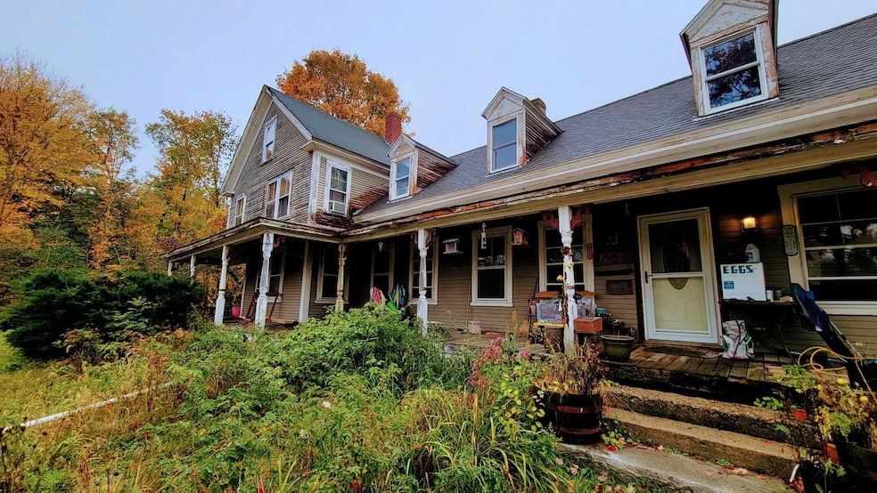
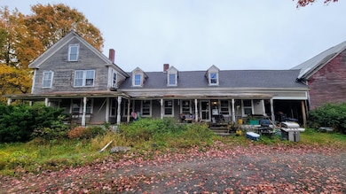
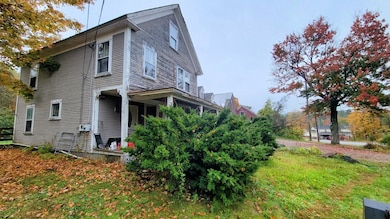
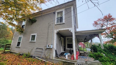
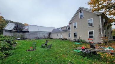
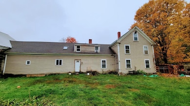
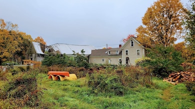
Calling all handymen and investors! This 1750 farmhouse is huge and in need of extensive rehabilitation. The property does have character with beautiful tin ceilings, impressive woodwork and large rooms. It would make for a finished product to be proud of. The barn is most likely a tear down. There is a nicely mowed backyard with fenced areas and fields. The home comes equipped with a Classic Edge 760 outdoor wood boiler to supplement the oil boiler, pellet stove and wood stove. This property abuts the gravel roadway to the Bolton Ballfields. Preapproval or proof of funds required prior to a showing. Property also listed as commercial at MLS 5065597. Is not conventional, FHA, or VA eligible.
Listing Agent
BHHS Verani Concord Brokerage Phone: 603-573-5353 License #075637 Listed on: 10/13/2025

Home Details
Home Type
- Single Family
Est. Annual Taxes
- $6,484
Year Built
- Built in 1750
Lot Details
- 2.02 Acre Lot
- Property is zoned Commercial
Parking
- Gravel Driveway
Home Design
- New Englander Architecture
- Wood Frame Construction
Interior Spaces
- Property has 2 Levels
- Dining Room
- Basement
- Walk-Up Access
Bedrooms and Bathrooms
- 5 Bedrooms
Schools
- Center Woods Elementary School
- Weare Middle School
- John Stark Regional High School
Utilities
- Baseboard Heating
- Boiler Heating System
- Dug Well
- Cable TV Available
Listing and Financial Details
- Tax Lot 173
- Assessor Parcel Number 411
Map
Home Values in the Area
Average Home Value in this Area
Tax History
| Year | Tax Paid | Tax Assessment Tax Assessment Total Assessment is a certain percentage of the fair market value that is determined by local assessors to be the total taxable value of land and additions on the property. | Land | Improvement |
|---|---|---|---|---|
| 2024 | $6,484 | $318,000 | $106,600 | $211,400 |
| 2023 | $5,991 | $318,000 | $106,600 | $211,400 |
| 2022 | $5,632 | $323,700 | $106,600 | $217,100 |
| 2021 | $5,568 | $323,700 | $106,600 | $217,100 |
| 2020 | $5,477 | $228,700 | $75,000 | $153,700 |
| 2019 | $5,422 | $228,700 | $75,000 | $153,700 |
| 2018 | $5,267 | $228,700 | $75,000 | $153,700 |
| 2016 | $5,116 | $228,700 | $75,000 | $153,700 |
| 2015 | $5,562 | $248,200 | $74,900 | $173,300 |
| 2014 | $5,513 | $248,200 | $74,900 | $173,300 |
| 2013 | $5,398 | $248,200 | $74,900 | $173,300 |
Property History
| Date | Event | Price | List to Sale | Price per Sq Ft |
|---|---|---|---|---|
| 10/13/2025 10/13/25 | For Sale | $255,000 | -- | $88 / Sq Ft |
Purchase History
| Date | Type | Sale Price | Title Company |
|---|---|---|---|
| Warranty Deed | $275,000 | -- |
Mortgage History
| Date | Status | Loan Amount | Loan Type |
|---|---|---|---|
| Open | $183,459 | No Value Available | |
| Closed | $195,000 | No Value Available |
Source: PrimeMLS
MLS Number: 5065599
APN: WEAR-000411-000000-000173
Disclaimer: Certain information contained herein is derived from information provided by parties other than Homes.com. All information provided is deemed reliable, but is not guaranteed to be accurate and should be independently verified.
![]() Copyright 2025 PrimeMLS, Inc. All rights reserved. This information is deemed reliable, but not guaranteed. The data relating to real estate displayed on this display comes in part from the IDX Program of PrimeMLS. The information being provided is for consumers’ personal, non-commercial use and may not be used for any purpose other than to identify prospective properties consumers may be interested in purchasing.
Copyright 2025 PrimeMLS, Inc. All rights reserved. This information is deemed reliable, but not guaranteed. The data relating to real estate displayed on this display comes in part from the IDX Program of PrimeMLS. The information being provided is for consumers’ personal, non-commercial use and may not be used for any purpose other than to identify prospective properties consumers may be interested in purchasing.
- 103 Renshaw Rd
- 77 Gould Rd
- 93 Daniels Rd
- 242 Colby Rd
- 196 Deering Center Rd
- 116 Martin Rd
- 174 S Stark Hwy Unit 13
- 174 S Stark Hwy Unit 23
- 238 Old Francestown Rd
- 22 Greenwood Rd
- 95 Wright Dr
- 29 N Riverdale Rd
- 849 River Rd
- 10 Sap House Rd
- 11 Ski Tow Rd
- 342 Weare Rd
- 0 Huntington Hill Rd Unit 69
- 200 Mountain Rd
- 24 Etta Ln Unit 3
- 1193 River Rd
- 115 High Rock Rd Unit A
- 30 High St Unit 2
- 86 Reservoir Dr
- 15 Factory St
- 15 Mountain Rd Unit 204
- 15 Mountain Rd Unit 106
- 15 Mountain Rd Unit 105
- 15 Mountain Rd Unit 202
- 15 Mountain Rd Unit 201
- 15 Mountain Rd Unit 101
- 15 Mountain Rd Unit 203
- 15 Mountain Rd Unit 102
- 15 Mountain Rd Unit 205
- 29 Center St Unit 5
- 29 Center St Unit 7
- 45 Greer Rd Unit 1
- 55 Holbrook Hill Rd
- 867 Quaker St
- 5 Timberwood Dr Unit 106
- 174 Saint Anselms Dr