Estimated Value: $111,000 - $155,000
2
Beds
1
Bath
897
Sq Ft
$142/Sq Ft
Est. Value
About This Home
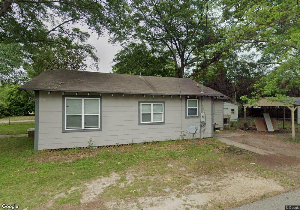
This home is located at 627 S George Ave, Petal, MS 39465 and is currently estimated at $127,530, approximately $142 per square foot. 627 S George Ave is a home located in Forrest County with nearby schools including Petal Primary School, Petal Elementary School, and Petal Upper Elementary School.
Ownership History
Date
Name
Owned For
Owner Type
Purchase Details
Closed on
Sep 10, 2021
Sold by
Sanford Samuel Kevin
Bought by
Weaver Liesa M
Current Estimated Value
Home Financials for this Owner
Home Financials are based on the most recent Mortgage that was taken out on this home.
Original Mortgage
$65,415
Outstanding Balance
$13,825
Interest Rate
2.8%
Mortgage Type
New Conventional
Estimated Equity
$113,705
Purchase Details
Closed on
Mar 26, 2009
Sold by
Wells Fargo Bank
Bought by
Sanford Samuel Kevin
Create a Home Valuation Report for This Property
The Home Valuation Report is an in-depth analysis detailing your home's value as well as a comparison with similar homes in the area
Home Values in the Area
Average Home Value in this Area
Purchase History
| Date | Buyer | Sale Price | Title Company |
|---|---|---|---|
| Weaver Liesa M | -- | Pine Belt Land Title | |
| Sanford Samuel Kevin | -- | -- |
Source: Public Records
Mortgage History
| Date | Status | Borrower | Loan Amount |
|---|---|---|---|
| Open | Weaver Liesa M | $65,415 |
Source: Public Records
Tax History Compared to Growth
Tax History
| Year | Tax Paid | Tax Assessment Tax Assessment Total Assessment is a certain percentage of the fair market value that is determined by local assessors to be the total taxable value of land and additions on the property. | Land | Improvement |
|---|---|---|---|---|
| 2024 | $1,282 | $7,268 | $0 | $0 |
| 2023 | $1,282 | $48,450 | $0 | $0 |
| 2022 | $1,245 | $7,268 | $0 | $0 |
| 2021 | $1,251 | $7,268 | $0 | $0 |
| 2020 | $623 | $4,705 | $0 | $0 |
| 2019 | $621 | $4,705 | $0 | $0 |
| 2018 | $623 | $4,705 | $0 | $0 |
| 2017 | $631 | $4,705 | $0 | $0 |
| 2016 | $598 | $4,489 | $0 | $0 |
| 2015 | $587 | $44,894 | $0 | $0 |
| 2014 | -- | $4,167 | $0 | $0 |
Source: Public Records
Map
Nearby Homes
- 619 S George Ave
- 737 S George Ave
- 701 S George Ave
- 622 S George Ave
- 617 S George Ave
- 617 S George St
- 620 S George Ave
- 615 S George Ave
- 618 S George Ave
- 706 S George St
- 613 S George Ave
- 706 S George Ave
- 711 Holmes St
- 719 Holmes St
- 717 Holmes St
- 715 Holmes St
- 713 Holmes St
- 611 S George Ave
- 709 Holmes St
- 0 Holmes S Holmes Street Holmes St Unit Lots 15 & 17 BLK C W