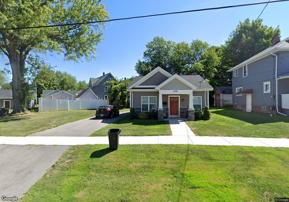
630 Grant Ave Unit 632 Dunkirk, NY 14048
Estimated Value: $106,000 - $145,000
1
Bed
1
Bath
800
Sq Ft
$160/Sq Ft
Est. Value
About This Home
This home is located at 630 Grant Ave Unit 632, Dunkirk, NY 14048 and is currently estimated at $127,702, approximately $159 per square foot. 630 Grant Ave Unit 632 is a home located in Chautauqua County with nearby schools including Dunkirk Intermediate School, Northern Chautauqua Catholic School, and Central Christian Academy.
Ownership History
Date
Name
Owned For
Owner Type
Purchase Details
Closed on
Nov 4, 2016
Sold by
Chaut Co Land Bank Corp
Bought by
Environments For Living Southern Tier
Current Estimated Value
Purchase Details
Closed on
Aug 7, 2014
Sold by
County Of Chautauqua
Bought by
Chaut County Land Bank Co
Purchase Details
Closed on
Jul 23, 2014
Sold by
Rivera Eddie
Bought by
County Of Chautauqua
Purchase Details
Closed on
Sep 16, 2005
Sold by
Comello Carol
Bought by
Rivera Eddie
Home Financials for this Owner
Home Financials are based on the most recent Mortgage that was taken out on this home.
Original Mortgage
$5,000
Interest Rate
5.92%
Mortgage Type
Purchase Money Mortgage
Purchase Details
Closed on
Nov 29, 1995
Sold by
Fafinski Matthew I
Bought by
Comello Carol
Create a Home Valuation Report for This Property
The Home Valuation Report is an in-depth analysis detailing your home's value as well as a comparison with similar homes in the area
Home Values in the Area
Average Home Value in this Area
Purchase History
| Date | Buyer | Sale Price | Title Company |
|---|---|---|---|
| Environments For Living Southern Tier | $7,500 | Steven Ald | |
| Chaut County Land Bank Co | -- | -- | |
| County Of Chautauqua | $3,483 | -- | |
| Rivera Eddie | $11,000 | Edwin J Kuzdale | |
| Comello Carol | $16,000 | -- |
Source: Public Records
Mortgage History
| Date | Status | Borrower | Loan Amount |
|---|---|---|---|
| Previous Owner | Rivera Eddie | $5,000 |
Source: Public Records
Tax History Compared to Growth
Tax History
| Year | Tax Paid | Tax Assessment Tax Assessment Total Assessment is a certain percentage of the fair market value that is determined by local assessors to be the total taxable value of land and additions on the property. | Land | Improvement |
|---|---|---|---|---|
| 2024 | $1 | $76,700 | $3,200 | $73,500 |
| 2023 | -- | $76,700 | $3,200 | $73,500 |
| 2022 | $0 | $76,700 | $3,200 | $73,500 |
| 2021 | $0 | $76,700 | $3,200 | $73,500 |
| 2020 | $99 | $76,700 | $3,200 | $73,500 |
| 2019 | $99 | $2,900 | $2,900 | $0 |
| 2018 | $99 | $2,900 | $2,900 | $0 |
| 2017 | $99 | $2,900 | $2,900 | $0 |
| 2016 | $0 | $2,900 | $2,900 | $0 |
| 2015 | -- | $16,000 | $2,900 | $13,100 |
| 2014 | -- | $16,000 | $2,900 | $13,100 |
Source: Public Records
Map
Nearby Homes
- 634 Grant Ave
- 119 Maple Ave
- 121 Maple Ave
- 117 Maple Ave Unit 17
- 123 Maple Ave Unit Lower
- 100 E 7th St
- 98 E 7th St
- 96 E 7th St
- 125 Maple Ave
- 115 Maple Ave
- 129 Maple Ave Unit Upper
- 129 Maple Ave
- 641 Grant Ave
- 639 Grant Ave
- 631 Grant Ave
- 645 Grant Ave
- 102 E 7th St
- 629 Grant Ave
- 135 Maple Ave
- 92 E 7th St