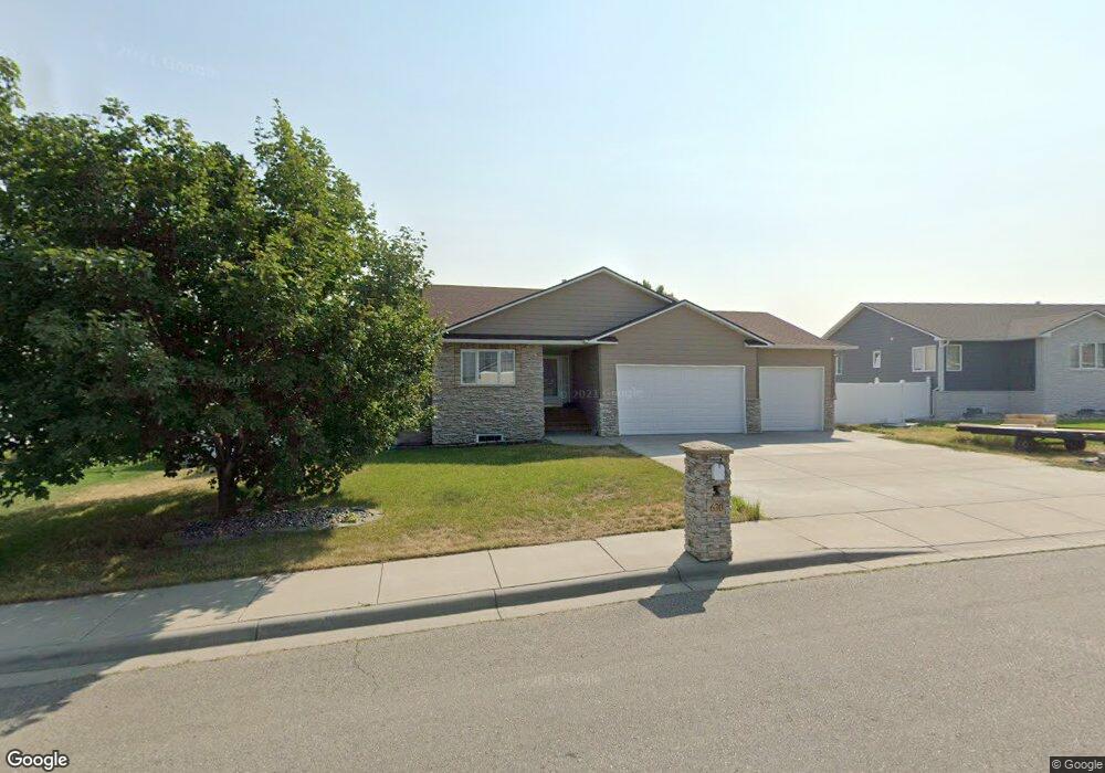
630 Pinehurst Rd Billings, MT 59105
Billings Heights NeighborhoodEstimated Value: $415,000 - $511,000
3
Beds
2
Baths
1,586
Sq Ft
$298/Sq Ft
Est. Value
About This Home
This home is located at 630 Pinehurst Rd, Billings, MT 59105 and is currently estimated at $472,342, approximately $297 per square foot. 630 Pinehurst Rd is a home located in Yellowstone County with nearby schools including Sandstone School, Castle Rock Junior High School, and Skyview High School.
Ownership History
Date
Name
Owned For
Owner Type
Purchase Details
Closed on
Jun 8, 2007
Sold by
Flynn J Nick and Flynn Onalee J
Bought by
Lynch Charles W
Current Estimated Value
Home Financials for this Owner
Home Financials are based on the most recent Mortgage that was taken out on this home.
Original Mortgage
$212,000
Outstanding Balance
$129,370
Interest Rate
6.14%
Mortgage Type
Purchase Money Mortgage
Estimated Equity
$342,972
Create a Home Valuation Report for This Property
The Home Valuation Report is an in-depth analysis detailing your home's value as well as a comparison with similar homes in the area
Home Values in the Area
Average Home Value in this Area
Purchase History
| Date | Buyer | Sale Price | Title Company |
|---|---|---|---|
| Lynch Charles W | -- | None Available |
Source: Public Records
Mortgage History
| Date | Status | Borrower | Loan Amount |
|---|---|---|---|
| Open | Lynch Charles W | $212,000 |
Source: Public Records
Tax History
| Year | Tax Paid | Tax Assessment Tax Assessment Total Assessment is a certain percentage of the fair market value that is determined by local assessors to be the total taxable value of land and additions on the property. | Land | Improvement |
|---|---|---|---|---|
| 2025 | $4,348 | $485,400 | $76,244 | $409,156 |
| 2024 | $4,348 | $442,200 | $66,290 | $375,910 |
| 2023 | $4,367 | $442,200 | $66,290 | $375,910 |
| 2022 | $3,624 | $318,400 | $0 | $0 |
| 2021 | $3,419 | $318,400 | $0 | $0 |
| 2020 | $3,375 | $301,500 | $0 | $0 |
| 2019 | $3,222 | $301,500 | $0 | $0 |
| 2018 | $3,111 | $285,300 | $0 | $0 |
| 2017 | $2,641 | $285,300 | $0 | $0 |
| 2016 | $2,737 | $260,400 | $0 | $0 |
| 2015 | $2,676 | $260,400 | $0 | $0 |
| 2014 | $2,563 | $132,712 | $0 | $0 |
Source: Public Records
Map
Nearby Homes
- 712 Oakmont Rd Unit 4
- 1931 Gleneagles Blvd
- TBD Gleneagles Blvd
- 1711 Clubhouse Way
- 2030 Gleneagles Blvd
- 2032 Clubhouse Way
- 0 Clubhouse Way
- 851 Tierra Dr
- 852 El Rancho Dr
- 990 Solita Dr
- 2107 Morocco Dr
- 0 Greenbriar Rd
- 00
- 2152 Gleneagles Blvd
- 00 Winged Foot Drive Lot 10
- Lot 5 Greenbriar Rd
- 2164 Greenbriar Rd
- 907 Presidio Ln
- 0 Winged Foot Dr
- 2213 Entrada Rd
- 640 Pinehurst Rd
- 620 Pinehurst Rd
- 635 Claremont Rd
- 595 Claremont Rd
- TBD Pinehurst Rd
- 627 Pinehurst Rd
- 645 Claremont Rd
- 610 Pinehurst Rd
- 585 Claremont Rd
- 637 Pinehurst Rd
- 655 Claremont Rd
- 617 Pinehurst Rd
- 0 Claremont Rd
- Lot 2 Claremont Rd
- Lot 5 Claremont Rd
- LOT 4 Claremont Rd
- Lot 8 Claremont Rd
- 622 Claremont Rd
- 665 Claremont Rd
- 575 Claremont Rd