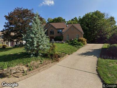
6304 Doe Cir Trafford, PA 15085
Penn Township NeighborhoodEstimated Value: $190,161 - $502,000
--
Bed
--
Bath
2,167
Sq Ft
$188/Sq Ft
Est. Value
About This Home
This home is located at 6304 Doe Cir, Trafford, PA 15085 and is currently estimated at $407,040, approximately $187 per square foot. 6304 Doe Cir is a home with nearby schools including Penn Trafford High School.
Ownership History
Date
Name
Owned For
Owner Type
Purchase Details
Closed on
Sep 25, 2024
Sold by
Goga Kenneth G and Goga Mary Ann
Bought by
Big Bird Family Trus
Current Estimated Value
Create a Home Valuation Report for This Property
The Home Valuation Report is an in-depth analysis detailing your home's value as well as a comparison with similar homes in the area
Home Values in the Area
Average Home Value in this Area
Purchase History
| Date | Buyer | Sale Price | Title Company |
|---|---|---|---|
| Big Bird Family Trus | -- | None Listed On Document |
Source: Public Records
Mortgage History
| Date | Status | Borrower | Loan Amount |
|---|---|---|---|
| Open | Big Bird Family Trust | $150,000 | |
| Previous Owner | Goga Kenneth G | $281,500 | |
| Previous Owner | Goga Kenneth G | $100,000 | |
| Previous Owner | Goga Kenneth G | $150,000 | |
| Previous Owner | Goga Kenneth G | $40,000 | |
| Previous Owner | Goga Ken G | $20,000 |
Source: Public Records
Tax History Compared to Growth
Tax History
| Year | Tax Paid | Tax Assessment Tax Assessment Total Assessment is a certain percentage of the fair market value that is determined by local assessors to be the total taxable value of land and additions on the property. | Land | Improvement |
|---|---|---|---|---|
| 2025 | $5,717 | $41,750 | $3,470 | $38,280 |
| 2024 | $5,675 | $41,750 | $3,470 | $38,280 |
| 2023 | $5,383 | $41,750 | $3,470 | $38,280 |
| 2022 | $5,321 | $41,750 | $3,470 | $38,280 |
| 2021 | $5,279 | $41,750 | $3,470 | $38,280 |
| 2020 | $5,237 | $41,750 | $3,470 | $38,280 |
| 2019 | $5,112 | $41,750 | $3,470 | $38,280 |
| 2018 | $4,966 | $41,750 | $3,470 | $38,280 |
| 2017 | $4,841 | $41,750 | $3,470 | $38,280 |
| 2016 | $4,699 | $41,750 | $3,470 | $38,280 |
| 2015 | $4,699 | $41,750 | $3,470 | $38,280 |
| 2014 | $4,615 | $41,750 | $3,470 | $38,280 |
Source: Public Records
Map
Nearby Homes
- 141 Terrace Ct
- 739 Route 130
- 708 State Route 130
- 4092 State Route 130
- 722 Shady Dr
- 301 Pine Hollow Rd
- 703 Meadowbrook Rd
- 102 Olive Dr
- 0 Newell Ln
- 124 Elm Dr
- 218 Sunrise Dr
- 305 Hemlock Rd
- 113 Saunders Station Rd
- 153 Sunrise Dr
- 125 Sunrise Dr Unit 2
- 143 Bradford Square Dr
- 145 Penn Woods Dr
- 233 Saunders Station Rd
- 13029 Pine Hollow Road Extension
- 1426 Lyons Chase Cir
- 6304 Doe Cir
- 6302 Doe Cir
- 6306 Doe Cir
- 6308 Doe Cir
- 10 Point Cir
- 6300 Doe Cir
- 6305 Doe Cir
- 6303 Doe Cir
- 6542 Ten Point Cir
- 6216 Antler Hill Dr
- 6540 Ten Point Cir
- 6307 Doe Cir
- 6301 Doe Cir
- 6214 Antler Hill Dr
- 6538 Ten Point Cir
- 6534 Ten Point Cir
- 6544 Ten Point Cir
- 6532 Ten Point Cir
- 6219 Antler Hill Dr
- 6212 Antler Hill Dr