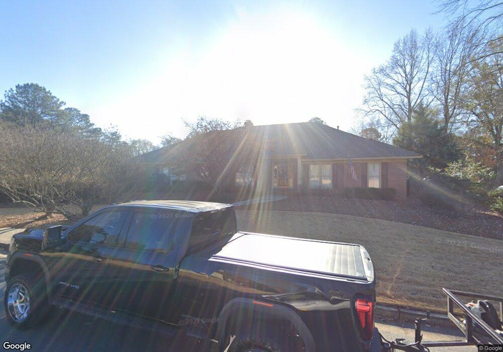
6310 Brookstone Blvd Columbus, GA 31904
Estimated Value: $411,000 - $465,000
4
Beds
3
Baths
3,285
Sq Ft
$133/Sq Ft
Est. Value
About This Home
This home is located at 6310 Brookstone Blvd, Columbus, GA 31904 and is currently estimated at $438,376, approximately $133 per square foot. 6310 Brookstone Blvd is a home located in Muscogee County with nearby schools including River Road Elementary School, Double Churches Middle School, and Northside High School.
Ownership History
Date
Name
Owned For
Owner Type
Purchase Details
Closed on
May 12, 2021
Sold by
Davis Jeffery L
Bought by
Brubaker Molly Reese and Brubaker Ethan
Current Estimated Value
Purchase Details
Closed on
May 14, 2008
Sold by
Murdock Robert N
Bought by
Murdock Marguerite M
Create a Home Valuation Report for This Property
The Home Valuation Report is an in-depth analysis detailing your home's value as well as a comparison with similar homes in the area
Home Values in the Area
Average Home Value in this Area
Purchase History
| Date | Buyer | Sale Price | Title Company |
|---|---|---|---|
| Brubaker Molly Reese | $372,000 | -- | |
| Murdock Marguerite M | -- | None Available |
Source: Public Records
Tax History Compared to Growth
Tax History
| Year | Tax Paid | Tax Assessment Tax Assessment Total Assessment is a certain percentage of the fair market value that is determined by local assessors to be the total taxable value of land and additions on the property. | Land | Improvement |
|---|---|---|---|---|
| 2025 | $2,534 | $162,840 | $23,256 | $139,584 |
| 2024 | $2,533 | $162,840 | $23,256 | $139,584 |
| 2023 | $1,855 | $162,840 | $23,256 | $139,584 |
| 2022 | $2,642 | $125,452 | $23,256 | $102,196 |
| 2021 | $2,635 | $125,876 | $23,256 | $102,620 |
| 2020 | $2,636 | $127,584 | $23,256 | $104,328 |
| 2019 | $2,646 | $127,584 | $23,256 | $104,328 |
| 2018 | $2,646 | $127,584 | $23,256 | $104,328 |
| 2017 | $2,656 | $126,880 | $23,256 | $103,624 |
| 2016 | $2,667 | $93,006 | $17,610 | $75,396 |
| 2015 | $2,672 | $93,006 | $17,610 | $75,396 |
| 2014 | $2,676 | $93,006 | $17,610 | $75,396 |
| 2013 | -- | $93,006 | $17,610 | $75,396 |
Source: Public Records
Map
Nearby Homes
- 6390 Cape Cod Dr
- 6333 Cape Cod Dr
- 5 Bridgecreek Ct
- 6130 Brookstone Blvd
- 6130 Bristol Blvd
- 235 Pebblebrook Ln
- 223 Pebblebrook Ln
- 7233 Mobley Walk Dr
- 239 Clearbrook Ln
- 280 Zachary Ct
- 521 Newport Place
- 5908 Brookstone Blvd
- 616 Newport Place
- 7020 Redwood Dr
- 7015 Spring Walk Dr
- 6101 River Rd Unit 2
- 438 Newport Place
- 7044 Spring Walk Dr
- 6969 Mobley Rd
- 6836 Sharmel Ln
- 6296 Brookstone Blvd
- 6405 Spring Water Dr
- 6421 Spring Water Dr
- 6320 Brookstone Blvd
- 6404 Spring Water Dr
- 6288 Brookstone Blvd
- 6404 Springwater Dr
- 6301 Brookstone Blvd
- 6401 Spring Water Dr
- 6420 Spring Water Dr
- 6427 Spring Water Dr
- 6328 Brookstone Blvd
- 6295 Brookstone Blvd
- 6374 Cape Cod Dr
- 6378 Cape Cod Dr
- 6426 Spring Water Dr
- 6370 Cape Cod Dr
- 6431 Springwater Dr
- 6329 Brookstone Blvd
- 28 Pinecreek Dr