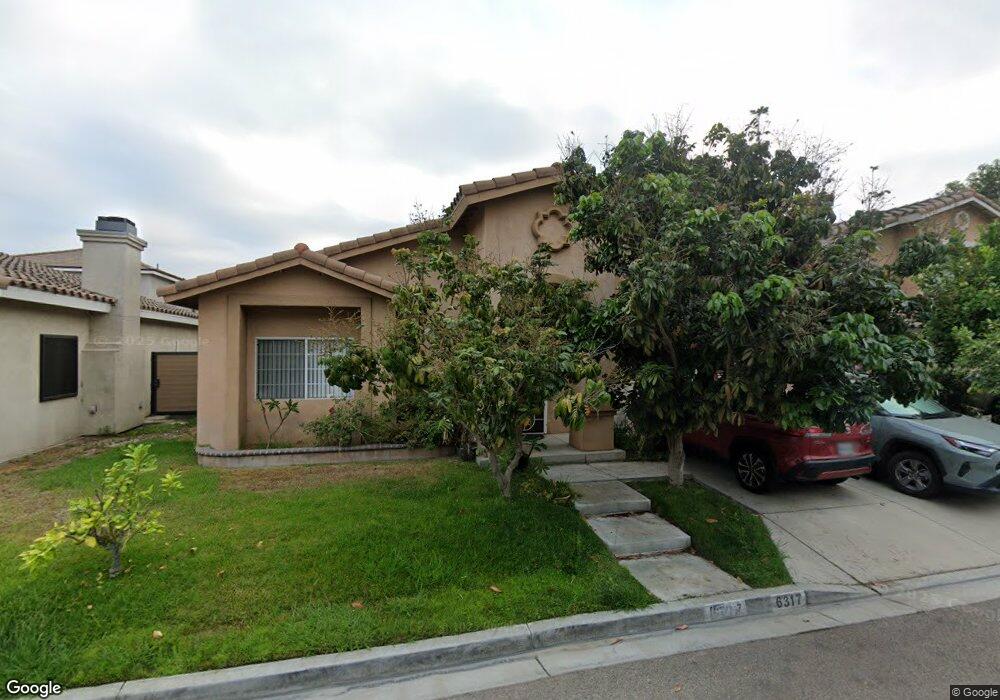
6317 Rancho Rio Rd Paramount, CA 90723
Estimated Value: $810,262 - $937,000
4
Beds
2
Baths
1,719
Sq Ft
$512/Sq Ft
Est. Value
About This Home
This home is located at 6317 Rancho Rio Rd, Paramount, CA 90723 and is currently estimated at $879,816, approximately $511 per square foot. 6317 Rancho Rio Rd is a home located in Los Angeles County with nearby schools including William Jefferson Clinton School, Roosevelt Middle School, and Dominguez High School.
Ownership History
Date
Name
Owned For
Owner Type
Purchase Details
Closed on
Aug 12, 2022
Sold by
Lay And Lean Hu Taing Family Trust
Bought by
Taing Lay and Taing Lean Hu
Current Estimated Value
Purchase Details
Closed on
May 17, 2019
Sold by
Taing Lay and Taing Lean Hu
Bought by
Taing Lay and Taing Lean Hu
Purchase Details
Closed on
Nov 28, 2001
Sold by
Ferrero Michael
Bought by
Taing Lay
Home Financials for this Owner
Home Financials are based on the most recent Mortgage that was taken out on this home.
Original Mortgage
$191,250
Interest Rate
6.73%
Create a Home Valuation Report for This Property
The Home Valuation Report is an in-depth analysis detailing your home's value as well as a comparison with similar homes in the area
Home Values in the Area
Average Home Value in this Area
Purchase History
| Date | Buyer | Sale Price | Title Company |
|---|---|---|---|
| Taing Lay | -- | None Listed On Document | |
| Taing Lay | -- | None Available | |
| Taing Lay | $255,000 | First American Title Co |
Source: Public Records
Mortgage History
| Date | Status | Borrower | Loan Amount |
|---|---|---|---|
| Previous Owner | Taing Lay | $191,250 |
Source: Public Records
Tax History
| Year | Tax Paid | Tax Assessment Tax Assessment Total Assessment is a certain percentage of the fair market value that is determined by local assessors to be the total taxable value of land and additions on the property. | Land | Improvement |
|---|---|---|---|---|
| 2025 | $5,057 | $376,691 | $147,720 | $228,971 |
| 2024 | $5,057 | $369,306 | $144,824 | $224,482 |
| 2023 | $4,965 | $362,066 | $141,985 | $220,081 |
| 2022 | $4,833 | $354,967 | $139,201 | $215,766 |
| 2021 | $4,719 | $348,008 | $136,472 | $211,536 |
| 2019 | $4,835 | $337,687 | $132,425 | $205,262 |
| 2018 | $4,492 | $331,067 | $129,829 | $201,238 |
| 2016 | $4,027 | $318,214 | $124,789 | $193,425 |
| 2015 | $3,799 | $313,435 | $122,915 | $190,520 |
| 2014 | $3,892 | $307,296 | $120,508 | $186,788 |
Source: Public Records
Map
Nearby Homes
- 16313 Hunsaker Ave
- 6950 Atlantic Ave
- 1050 E 72nd St
- 15812 Atlantic
- 1208 S White Ave
- 6824 Marcelle St
- 6733 Caro St Unit 47
- 6882 Alondra Blvd Unit 26
- 16600 Orange Ave Unit 124
- 16600 Orange Ave Unit 146
- 16600 Orange Ave Unit 130
- 16600 Orange Ave Unit 48
- 16710 Orange Ave Unit L59
- 15412 S Atlantic Ave
- 15211 S Gibson Ave
- 15351 Orange Ave Unit 17
- 15325 Orange Ave
- 16330 S Caress Ave
- 253 Orleans Way
- 2201 E Alondra Blvd
- 6313 Rancho Rio Rd
- 6321 Rancho Rio Rd
- 6314 Rancho Parada Rd
- 6316 Rancho Rio Rd
- 6310 Rancho Parada Rd
- 6312 Rancho Parada Rd
- 6318 Rancho Parada Rd
- 6309 Rancho Rio Rd
- 6308 Rancho Parada Rd
- 6311 Rancho Parada Rd
- 6312 Rancho Rio Rd
- 6306 Rancho Parada Rd
- 6305 Rancho Rio Rd
- 6304 Rancho Parada Rd
- 16311 N Atlantic Place
- 16314 Rancho Portillo Rd
- 7191 N Atlantic Place
- 16309 Atlantic Place
- 16314 Atlantic Place
- 16312 Rancho Portillo Rd
Your Personal Tour Guide
Ask me questions while you tour the home.