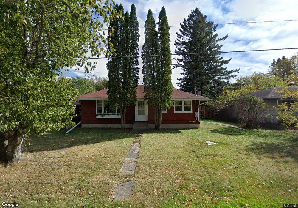
632 Main St N Winton, MN 55796
Estimated Value: $69,000 - $201,000
Studio
--
Bath
--
Sq Ft
3,180
Sq Ft Lot
About This Home
This home is located at 632 Main St N, Winton, MN 55796 and is currently estimated at $134,869. 632 Main St N is a home with nearby schools including Washington Elementary School and Memorial High School.
Ownership History
Date
Name
Owned For
Owner Type
Purchase Details
Closed on
Mar 1, 2018
Sold by
Karklins Steven D and Johnson Sharee L
Bought by
Karklins Steven D and Johnson Sharee L
Current Estimated Value
Purchase Details
Closed on
Dec 5, 2003
Sold by
Ruoho David O and Ruoho Edye L
Bought by
Karklins Steve D and Johnson Sharee L
Purchase Details
Closed on
Jul 16, 2002
Sold by
Tuthill Lana M and Tuthill Gary
Bought by
Ruoho David O and Ruoho Edye L
Home Financials for this Owner
Home Financials are based on the most recent Mortgage that was taken out on this home.
Original Mortgage
$65,000
Interest Rate
6.7%
Purchase Details
Closed on
Dec 3, 2001
Sold by
Christian Helvi O
Bought by
Tuthill Lana M and Christian Keith D
Create a Home Valuation Report for This Property
The Home Valuation Report is an in-depth analysis detailing your home's value as well as a comparison with similar homes in the area
Purchase History
| Date | Buyer | Sale Price | Title Company |
|---|---|---|---|
| Karklins Steven D | -- | None Available | |
| Karklins Steve D | $110,000 | Northeast Title Company | |
| Ruoho David O | $83,000 | Ati Title Company | |
| Tuthill Lana M | $59,000 | -- |
Source: Public Records
Mortgage History
| Date | Status | Borrower | Loan Amount |
|---|---|---|---|
| Previous Owner | Ruoho David O | $65,000 |
Source: Public Records
Tax History Compared to Growth
Tax History
| Year | Tax Paid | Tax Assessment Tax Assessment Total Assessment is a certain percentage of the fair market value that is determined by local assessors to be the total taxable value of land and additions on the property. | Land | Improvement |
|---|---|---|---|---|
| 2024 | $194 | $10,700 | $10,700 | $0 |
| 2023 | $194 | $9,800 | $9,800 | $0 |
| 2022 | $140 | $8,900 | $8,900 | $0 |
| 2021 | $306 | $7,100 | $7,100 | $0 |
| 2020 | $290 | $14,200 | $14,200 | $0 |
| 2019 | $276 | $14,200 | $14,200 | $0 |
| 2018 | $280 | $14,200 | $14,200 | $0 |
| 2017 | $280 | $14,200 | $14,200 | $0 |
| 2016 | $336 | $14,200 | $14,200 | $0 |
| 2015 | $333 | $18,200 | $18,200 | $0 |
| 2014 | $333 | $18,200 | $18,200 | $0 |
Source: Public Records
Map
Nearby Homes
- XXX10 Powerhouse Trail
- XXX9 Powerhouse Trail
- XX Sellwood Rd
- 1280 Heather St
- 2221 Sibley Dr
- 2231 Sibley Dr
- 1530 N 20th Ave E
- 2101 Sibley Ct
- 438 Buck View Rd
- 13359 Villa Rd
- 631 Circle Dr
- 1151 E Camp St
- TBD Hill Top Rd
- TBD Trezona Rd
- 540 Loop Rd
- 738 E Camp St
- 246 N 5th Ave E
- 14108 Fall Lake Rd
- 1247 Wolf Den Dr
- 313 E Chapman St
- 618 618 Main St
- 618 Main St
- 606 Main St N
- 625 Main St N
- 607 N Main St
- 1168 1168 Winton Rd Unit Old Winton Road
- 102 Winton Point Rd
- 105 Winton Pt Rd
- 105 Winton Point Rd
- 105 Winton Point Rd
- 558 Front St N
- 548 Saint Croix Dr
- 544 Saint Croix Dr
- 548 Front St N
- 500 Main St
- 500 Main St Unit Lynx Place 2
- 548 Front St
- 536 Saint Croix Dr
- 536 St Croix St
- 538 Front St