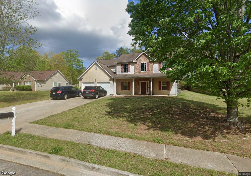
632 Penstock Path Hampton, GA 30228
Estimated Value: $316,925 - $331,000
4
Beds
3
Baths
2,437
Sq Ft
$133/Sq Ft
Est. Value
About This Home
This home is located at 632 Penstock Path, Hampton, GA 30228 and is currently estimated at $323,481, approximately $132 per square foot. 632 Penstock Path is a home located in Henry County with nearby schools including Mount Carmel Elementary School, Hampton Middle School, and Hampton High School.
Ownership History
Date
Name
Owned For
Owner Type
Purchase Details
Closed on
Feb 2, 2007
Sold by
Knight Group Inc
Bought by
Blades Mark and Forde Anete
Current Estimated Value
Home Financials for this Owner
Home Financials are based on the most recent Mortgage that was taken out on this home.
Original Mortgage
$152,152
Outstanding Balance
$90,266
Interest Rate
6.08%
Mortgage Type
New Conventional
Estimated Equity
$233,215
Create a Home Valuation Report for This Property
The Home Valuation Report is an in-depth analysis detailing your home's value as well as a comparison with similar homes in the area
Home Values in the Area
Average Home Value in this Area
Purchase History
| Date | Buyer | Sale Price | Title Company |
|---|---|---|---|
| Blades Mark | $190,200 | -- |
Source: Public Records
Mortgage History
| Date | Status | Borrower | Loan Amount |
|---|---|---|---|
| Open | Blades Mark | $152,152 |
Source: Public Records
Tax History
| Year | Tax Paid | Tax Assessment Tax Assessment Total Assessment is a certain percentage of the fair market value that is determined by local assessors to be the total taxable value of land and additions on the property. | Land | Improvement |
|---|---|---|---|---|
| 2025 | $5,313 | $132,680 | $16,000 | $116,680 |
| 2024 | $5,313 | $128,200 | $16,000 | $112,200 |
| 2023 | $4,736 | $121,680 | $14,000 | $107,680 |
| 2022 | $3,856 | $98,760 | $14,000 | $84,760 |
| 2021 | $3,407 | $87,040 | $14,000 | $73,040 |
| 2020 | $3,069 | $78,240 | $10,000 | $68,240 |
| 2019 | $2,589 | $65,720 | $10,000 | $55,720 |
| 2018 | $2,616 | $66,440 | $10,000 | $56,440 |
| 2016 | $2,374 | $60,120 | $8,600 | $51,520 |
| 2015 | $2,229 | $54,640 | $8,600 | $46,040 |
| 2014 | $2,268 | $54,960 | $8,000 | $46,960 |
Source: Public Records
Map
Nearby Homes
- 80 Knolls Ridge
- 417 Ryoaks Dr
- 208 Deodar Ln
- 1201 Pendley Point
- 1209 Pendley Point
- 1200 Pendley Point
- 1438 Highway 3 N
- 220 Windpher Ridge
- 260 Sandstone Dr
- 101 River View Ct
- 269 Makenna Dr
- 417 Sawmill Trace
- 120 Bridgemill Dr
- 173 Goldleaf Dr
- 244 Dodgen Rd
- 116 Cabin Way
- 120 Cabin Way
- 446 Sawmill Trace
- 456 Pearson Cir
- 455 Pearson Cir
- 636 Penstock Path
- 628 Penstock Path
- 640 Penstock Path
- 171 Fears Dr
- 171 Fears Dr Unit /75
- 625 Penstock Path
- 639 Penstock Path Unit 117
- 639 Penstock Path
- 644 Penstock Path
- 161 Fears Dr
- 954 Damson Trail
- 648 Penstock Path
- 157 Fears Dr Unit 1
- 168 Fears Dr
- 649 Penstock Path
- 172 Fears Dr
- 185 Fears Dr
- 621 Penstock Path
- 950 Damson Trail
- 176 Fears Dr
Your Personal Tour Guide
Ask me questions while you tour the home.