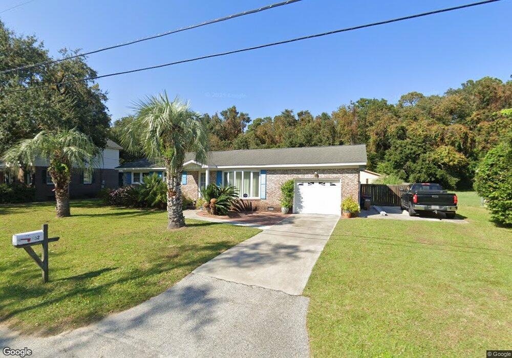
632 Schooner Rd Charleston, SC 29412
James Island NeighborhoodEstimated Value: $611,816 - $687,000
3
Beds
2
Baths
1,642
Sq Ft
$392/Sq Ft
Est. Value
About This Home
This home is located at 632 Schooner Rd, Charleston, SC 29412 and is currently estimated at $643,704, approximately $392 per square foot. 632 Schooner Rd is a home located in Charleston County with nearby schools including Stiles Point Elementary School, Camp Road Middle, and James Island Charter High School.
Ownership History
Date
Name
Owned For
Owner Type
Purchase Details
Closed on
Aug 15, 2013
Sold by
Bozzelli Michael Patrick
Bought by
Wiedrich Nathan E and Wiedrich Cori M
Current Estimated Value
Home Financials for this Owner
Home Financials are based on the most recent Mortgage that was taken out on this home.
Original Mortgage
$265,109
Outstanding Balance
$200,867
Interest Rate
4.87%
Mortgage Type
FHA
Estimated Equity
$442,837
Purchase Details
Closed on
Dec 16, 2004
Sold by
Perron Raymond A and Perron Mauricette M
Bought by
Perron Raymond A and Perron Mauricette M
Create a Home Valuation Report for This Property
The Home Valuation Report is an in-depth analysis detailing your home's value as well as a comparison with similar homes in the area
Home Values in the Area
Average Home Value in this Area
Purchase History
| Date | Buyer | Sale Price | Title Company |
|---|---|---|---|
| Wiedrich Nathan E | $270,000 | -- | |
| Perron Raymond A | -- | -- |
Source: Public Records
Mortgage History
| Date | Status | Borrower | Loan Amount |
|---|---|---|---|
| Open | Wiedrich Nathan E | $265,109 |
Source: Public Records
Tax History Compared to Growth
Tax History
| Year | Tax Paid | Tax Assessment Tax Assessment Total Assessment is a certain percentage of the fair market value that is determined by local assessors to be the total taxable value of land and additions on the property. | Land | Improvement |
|---|---|---|---|---|
| 2024 | $1,241 | $7,740 | $0 | $0 |
| 2023 | $1,019 | $7,740 | $0 | $0 |
| 2022 | $912 | $7,740 | $0 | $0 |
| 2021 | $972 | $7,740 | $0 | $0 |
| 2020 | $982 | $7,740 | $0 | $0 |
| 2019 | $873 | $6,470 | $0 | $0 |
| 2017 | $923 | $8,470 | $0 | $0 |
| 2016 | $887 | $8,470 | $0 | $0 |
| 2015 | $914 | $8,470 | $0 | $0 |
| 2014 | $747 | $0 | $0 | $0 |
| 2011 | -- | $0 | $0 | $0 |
Source: Public Records
Map
Nearby Homes
- 634 Lynne Ave
- 764 Creekside Dr
- 746 Tallwood Rd
- 922 Preston Rd
- 939 Mikell Dr
- 832 Robert e Lee Blvd
- 1313 Salt Marsh Cove
- 660 Ayers Dr
- 957 Regatta Rd
- 672 Ayers Dr
- 965 Mooring Dr
- 544 Fort Johnson Rd
- 762 Swanson Ave
- 3009 Allison Cove Dr
- 683 Edmonds Dr
- 706 Sterling Dr
- 1024 Greenhill Rd
- 460 Trapier Dr
- 0 Fort Johnson Rd Unit 25005735
- 1032 Greenhill Rd Unit A
- 628 Schooner Rd
- 638 Schooner Rd
- 622 Schooner Rd
- 642 Schooner Rd
- 629 Schooner Rd
- 637 Schooner Rd
- 623 Schooner Rd
- 618 Schooner Rd
- 619 Schooner Rd
- 641 Schooner Rd
- 615 Schooner Rd
- 614 Schooner Rd
- 652 Schooner Rd
- 645 Schooner Rd
- 655 Schooner Rd
- 665 Schooner Rd
- 612 Parrot Point Dr Unit LOT 13
- 0 Parrot Point Dr
- 0 Schooner Rd Unit A&C 2731719
- 0 Schooner Rd Unit A&C 2827013