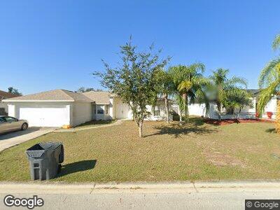
6324 Hampton Pointe Cir Lakeland, FL 33813
Estimated Value: $300,646 - $311,000
3
Beds
2
Baths
1,528
Sq Ft
$200/Sq Ft
Est. Value
About This Home
This home is located at 6324 Hampton Pointe Cir, Lakeland, FL 33813 and is currently estimated at $305,912, approximately $200 per square foot. 6324 Hampton Pointe Cir is a home located in Polk County with nearby schools including Spessard L Holland Elementary School, Bartow Elementary Academy, and Bartow Middle School.
Ownership History
Date
Name
Owned For
Owner Type
Purchase Details
Closed on
May 20, 2005
Sold by
Persaud Sunil T and Persaud Shelly L
Bought by
Persaud Properties Llc
Current Estimated Value
Purchase Details
Closed on
Oct 5, 2004
Sold by
Highland Holdings Inc
Bought by
Persaud Sunil T and Persaud Shelly L
Home Financials for this Owner
Home Financials are based on the most recent Mortgage that was taken out on this home.
Original Mortgage
$106,425
Interest Rate
5.71%
Mortgage Type
Purchase Money Mortgage
Create a Home Valuation Report for This Property
The Home Valuation Report is an in-depth analysis detailing your home's value as well as a comparison with similar homes in the area
Home Values in the Area
Average Home Value in this Area
Purchase History
| Date | Buyer | Sale Price | Title Company |
|---|---|---|---|
| Persaud Properties Llc | -- | -- | |
| Persaud Sunil T | $23,000 | -- | |
| Highland Holdings Llc | $22,000 | -- |
Source: Public Records
Mortgage History
| Date | Status | Borrower | Loan Amount |
|---|---|---|---|
| Previous Owner | Persaud Sunil T | $106,425 |
Source: Public Records
Tax History Compared to Growth
Tax History
| Year | Tax Paid | Tax Assessment Tax Assessment Total Assessment is a certain percentage of the fair market value that is determined by local assessors to be the total taxable value of land and additions on the property. | Land | Improvement |
|---|---|---|---|---|
| 2023 | $3,494 | $207,474 | $0 | $0 |
| 2022 | $3,217 | $188,613 | $0 | $0 |
| 2021 | $2,914 | $171,466 | $34,000 | $137,466 |
| 2020 | $2,712 | $157,095 | $32,000 | $125,095 |
| 2018 | $2,542 | $141,687 | $31,000 | $110,687 |
| 2017 | $2,351 | $129,459 | $0 | $0 |
| 2016 | $2,293 | $125,329 | $0 | $0 |
| 2015 | $1,746 | $115,235 | $0 | $0 |
| 2014 | $1,993 | $109,650 | $0 | $0 |
Source: Public Records
Map
Nearby Homes
- 4219 Sunny Land Dr
- 4211 Sunny Land Dr
- 4202 Sunny View Dr
- 4364 Reding Way
- 4089 Lehman Ln
- 4035 Crews Ln
- 6512 Polly Ln
- 4038 Lehman Ln
- 6087 Sunset Vista Dr
- 6317 Georgia Ave
- 6036 Mission Dr
- 6421 Alamanda Hills Dr
- 4009 Oakley Way
- 5939 Stokes Rd
- 4743 Bold Peacock Bend
- 2250 Country Manor St
- 2240 Country Manor St
- 6358 Alamanda Hills Dr
- 1918 Wind Meadows Dr
- 3933 Strickland Ct
- 6324 Hampton Pointe Cir
- 6318 Hampton Pointe Cir
- 6330 Hampton Pointe Cir
- 6274 Hampton Pointe Cir
- 6336 Hampton Pointe Cir
- 6280 Hampton Pointe Cir
- 6312 Hampton Pointe Cir
- 6268 Hampton Pointe Cir
- 6250 Hampton Pointe Cir
- 6289 Hampton Pointe Cir
- 6247 Hampton Pointe Cir
- 6327 Hampton Pointe Cir
- 6321 Hampton Pointe Cir
- 6286 Hampton Pointe Cir
- 6262 Hampton Pointe Cir
- 6333 Hampton Pointe Cir
- 6315 Hampton Pointe Cir
- 6238 Hampton Pointe Cir
- 6339 Hampton Pointe Cir