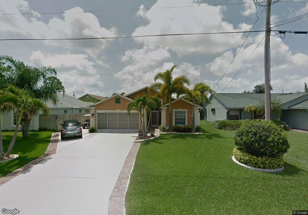
6334 Michael St Jupiter, FL 33458
North Palm Beach Heights NeighborhoodEstimated Value: $595,000 - $665,000
3
Beds
2
Baths
1,584
Sq Ft
$388/Sq Ft
Est. Value
About This Home
This home is located at 6334 Michael St, Jupiter, FL 33458 and is currently estimated at $615,231, approximately $388 per square foot. 6334 Michael St is a home located in Palm Beach County with nearby schools including Lighthouse Elementary School, William T. Dwyer High School, and Beacon Cove Intermediate School.
Ownership History
Date
Name
Owned For
Owner Type
Purchase Details
Closed on
Apr 7, 2005
Sold by
Popke Todd D and Popke Phyllis E
Bought by
Popke Todd D
Current Estimated Value
Home Financials for this Owner
Home Financials are based on the most recent Mortgage that was taken out on this home.
Original Mortgage
$247,500
Interest Rate
5.74%
Mortgage Type
Stand Alone Refi Refinance Of Original Loan
Purchase Details
Closed on
Apr 2, 2001
Sold by
Lobilt Inc
Bought by
Popke Todd D
Home Financials for this Owner
Home Financials are based on the most recent Mortgage that was taken out on this home.
Original Mortgage
$151,900
Interest Rate
7.02%
Mortgage Type
Purchase Money Mortgage
Create a Home Valuation Report for This Property
The Home Valuation Report is an in-depth analysis detailing your home's value as well as a comparison with similar homes in the area
Home Values in the Area
Average Home Value in this Area
Purchase History
| Date | Buyer | Sale Price | Title Company |
|---|---|---|---|
| Popke Todd D | -- | Clarion Title Company Inc | |
| Popke Todd D | $28,000 | -- |
Source: Public Records
Mortgage History
| Date | Status | Borrower | Loan Amount |
|---|---|---|---|
| Open | Popke Todd D | $206,446 | |
| Closed | Popke Todd D | $247,500 | |
| Previous Owner | Popke Todd D | $151,900 | |
| Closed | Popke Todd D | $54,000 |
Source: Public Records
Tax History
| Year | Tax Paid | Tax Assessment Tax Assessment Total Assessment is a certain percentage of the fair market value that is determined by local assessors to be the total taxable value of land and additions on the property. | Land | Improvement |
|---|---|---|---|---|
| 2025 | $3,344 | $219,193 | -- | -- |
| 2024 | $3,344 | $213,016 | -- | -- |
| 2023 | $3,281 | $206,812 | $0 | $0 |
| 2022 | $3,248 | $200,788 | $0 | $0 |
| 2021 | $3,203 | $194,940 | $0 | $0 |
| 2020 | $3,190 | $192,249 | $0 | $0 |
| 2019 | $3,142 | $187,927 | $0 | $0 |
| 2018 | $2,978 | $184,423 | $0 | $0 |
| 2017 | $2,959 | $180,630 | $0 | $0 |
| 2016 | $2,928 | $176,915 | $0 | $0 |
| 2015 | $3,016 | $175,685 | $0 | $0 |
| 2014 | $3,028 | $174,291 | $0 | $0 |
Source: Public Records
Map
Nearby Homes
- 6325 Drake St
- 6334 Foster St
- 6435 Foster St
- 6249 Foster St
- 6418 Pompano St
- 6085 Robinson St
- 484 Otter Ln N
- 429 Oriole Cir
- 6799 149th Place N
- 6945 150th Place N
- 6031 Robinson St
- 3518 Community Dr
- 14771 66th Trail N
- 6039 Adams St
- 236 Sparrow Point
- 6253 Francis St
- 227 Caravelle Dr
- 231 Sparrow Point
- 136 Ashley Ct
- 6130 Francis St
- 6352 Michael St
- 6326 Michael St
- 6335 Lucerne St
- 6341 Lucerne St
- 6327 Lucerne St
- 6318 Michael St
- 15184 Harriet Ave
- 6335 Michael St
- 6351 Lucerne St
- 6321 Lucerne St
- 6343 Michael St
- 6327 Michael St
- 6312 Michael St
- 6319 Michael St
- 6351 Michael St
- 6315 Lucerne St
- 6356 Michael St
- 6304 Michael St
- 6311 Michael St
- 6305 Lucerne St
Your Personal Tour Guide
Ask me questions while you tour the home.