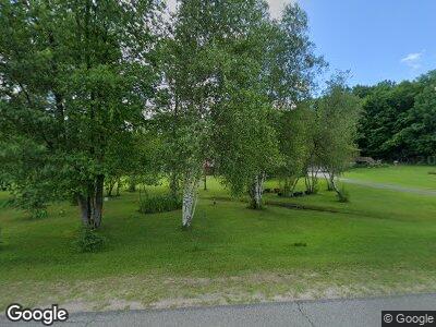
635 Butternut Ridge Rd Canton, NY 13617
Estimated Value: $171,028 - $198,000
3
Beds
2
Baths
2,200
Sq Ft
$81/Sq Ft
Est. Value
About This Home
This home is located at 635 Butternut Ridge Rd, Canton, NY 13617 and is currently estimated at $178,507, approximately $81 per square foot. 635 Butternut Ridge Rd is a home located in St. Lawrence County with nearby schools including F.S. Banford Elementary School, J.M. McKenney Middle School, and H.C. Williams Senior High School.
Ownership History
Date
Name
Owned For
Owner Type
Purchase Details
Closed on
Nov 3, 2005
Sold by
Cambridge Mark
Bought by
Murdie Scott
Current Estimated Value
Home Financials for this Owner
Home Financials are based on the most recent Mortgage that was taken out on this home.
Original Mortgage
$35,000
Interest Rate
6.07%
Mortgage Type
Purchase Money Mortgage
Create a Home Valuation Report for This Property
The Home Valuation Report is an in-depth analysis detailing your home's value as well as a comparison with similar homes in the area
Home Values in the Area
Average Home Value in this Area
Purchase History
| Date | Buyer | Sale Price | Title Company |
|---|---|---|---|
| Murdie Scott | $85,000 | -- |
Source: Public Records
Mortgage History
| Date | Status | Borrower | Loan Amount |
|---|---|---|---|
| Open | Murdie Scott R | $90,000 | |
| Closed | Murdie Scott R | $16,000 | |
| Closed | Murdie Scott | $65,000 | |
| Closed | Murdie Scott | $35,000 |
Source: Public Records
Tax History Compared to Growth
Tax History
| Year | Tax Paid | Tax Assessment Tax Assessment Total Assessment is a certain percentage of the fair market value that is determined by local assessors to be the total taxable value of land and additions on the property. | Land | Improvement |
|---|---|---|---|---|
| 2024 | $4,758 | $106,140 | $8,800 | $97,340 |
| 2023 | $4,434 | $106,140 | $8,800 | $97,340 |
| 2022 | $4,482 | $106,140 | $8,800 | $97,340 |
| 2021 | $4,301 | $106,140 | $8,800 | $97,340 |
| 2020 | $3,643 | $106,140 | $8,800 | $97,340 |
| 2019 | $3,835 | $106,140 | $8,800 | $97,340 |
| 2018 | $3,835 | $106,140 | $8,800 | $97,340 |
| 2017 | $3,794 | $106,140 | $8,800 | $97,340 |
| 2016 | $3,789 | $103,840 | $8,800 | $95,040 |
| 2015 | -- | $103,840 | $8,800 | $95,040 |
| 2014 | -- | $103,840 | $8,800 | $95,040 |
Source: Public Records
Map
Nearby Homes
- 1079 State Highway 68
- 196 Noyes Rd
- 6075 County Route 24
- 163 Noyes Rd
- 5715 County Road 24
- 5730 County Road 24
- 780 Farnes Rd
- 6658 County Route 24
- 136 T Alexander Dr (Prvt)
- 91 Birch Dr
- 235 Hanson Rd
- 18 McKabe Rd
- 2018 River Rd
- 2032 River Rd
- 0 New York 56
- 00 New York 56
- 127 Benson Rd
- 00 River Rd
- 264 Gulf Rd
- 5955 State Highway 56
- 635 Butternut Ridge Rd
- 605 Butternut Ridge Rd
- 681 Butternut Ridge Rd
- 592 Butternut Ridge Rd
- 584 Butternut Ridge Rd
- 556 Butternut Ridge Rd
- 420 Post Rd
- 379 Post Rd
- 363 Post Rd
- 744 Butternut Ridge Rd
- 13 Ayres Rd
- 332 Church Rd
- 326 Post Rd
- 782 Butternut Ridge Rd
- 325 Church Rd
- 315 Church Rd
- 90 Powers Rd
- 300 Post Rd
- 809 Butternut Ridge Rd
- 236 Church Rd
