Estimated Value: $308,789 - $341,000
3
Beds
2
Baths
1,448
Sq Ft
$223/Sq Ft
Est. Value
About This Home
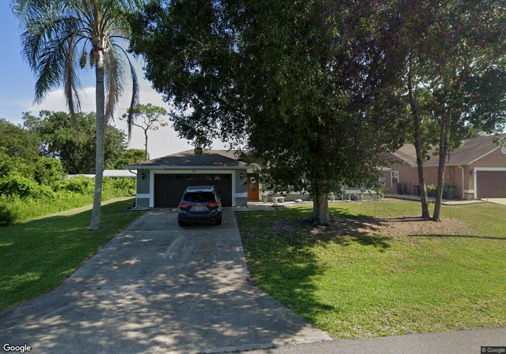
This home is located at 6373 Dearman St, Cocoa, FL 32927 and is currently estimated at $322,447, approximately $222 per square foot. 6373 Dearman St is a home located in Brevard County with nearby schools including Enterprise Elementary School, Space Coast Junior/Senior High School, and East Atlantic Prep of Brevard County.
Ownership History
Date
Name
Owned For
Owner Type
Purchase Details
Closed on
Sep 27, 2007
Sold by
Stowe Dennis E
Bought by
Lagle David L and Lagle Patricia L
Current Estimated Value
Home Financials for this Owner
Home Financials are based on the most recent Mortgage that was taken out on this home.
Original Mortgage
$121,600
Outstanding Balance
$77,340
Interest Rate
6.57%
Estimated Equity
$245,107
Purchase Details
Closed on
Mar 18, 2005
Sold by
Stowe Dennis E and Stowe Sherry A
Bought by
Stowe Dennis E
Home Financials for this Owner
Home Financials are based on the most recent Mortgage that was taken out on this home.
Original Mortgage
$62,000
Interest Rate
5.57%
Create a Home Valuation Report for This Property
The Home Valuation Report is an in-depth analysis detailing your home's value as well as a comparison with similar homes in the area
Home Values in the Area
Average Home Value in this Area
Purchase History
| Date | Buyer | Sale Price | Title Company |
|---|---|---|---|
| Lagle David L | $152,000 | Landamerica Gulfatlantic Tit | |
| Stowe Dennis E | -- | Security First Title Partner |
Source: Public Records
Mortgage History
| Date | Status | Borrower | Loan Amount |
|---|---|---|---|
| Open | Lagle David L | $121,600 | |
| Previous Owner | Stowe Dennis E | $62,000 |
Source: Public Records
Tax History Compared to Growth
Tax History
| Year | Tax Paid | Tax Assessment Tax Assessment Total Assessment is a certain percentage of the fair market value that is determined by local assessors to be the total taxable value of land and additions on the property. | Land | Improvement |
|---|---|---|---|---|
| 2025 | $1,260 | $90,310 | -- | -- |
| 2024 | $1,222 | $87,770 | -- | -- |
| 2023 | $1,222 | $85,100 | $0 | $0 |
| 2022 | $1,137 | $82,630 | $0 | $0 |
| 2021 | $1,127 | $80,230 | $0 | $0 |
| 2020 | $1,061 | $79,130 | $0 | $0 |
| 2019 | $995 | $77,360 | $0 | $0 |
| 2018 | $985 | $75,920 | $0 | $0 |
| 2017 | $977 | $74,360 | $0 | $0 |
| 2016 | $987 | $72,840 | $18,000 | $54,840 |
| 2015 | $997 | $72,340 | $15,000 | $57,340 |
| 2014 | $1,002 | $71,770 | $11,000 | $60,770 |
Source: Public Records
Map
Nearby Homes
- 6481 Muller Ave
- 6295 Banyan St
- 6530 Bethel St
- 6115 Allmont St
- 6198 Dees Rd
- 6470 Aberdeen Ave
- 00000 Golfview Ave
- 6545 Addie Ave
- 6105 Banyan St
- 6118 Dees Rd
- 23-35-21-JX-B-2 Aruin St
- 6070 Baltimore Ave
- 6365 Homestead Ave
- 6665 Addie Ave
- 0 Golfview Ave
- 5915 Akers St
- 6010 Fay Blvd
- 6180 Balboa St
- 6309 Alleghany Ave
- 5940 Fisherman Ln
- 6381 Dearman St
- 6372 Dearman St
- 6374 Brack St
- 6366 Brack St
- 6357 Dearman St
- 6380 Dearman St
- 6358 Brack St
- 6379 Brack St
- 6365 Dearman St
- 6364 Dearman St
- 6350 Brack St
- 6400 Golfview Ave
- 6410 Golfview Ave
- 6390 Golfview Ave
- 6348 Dearman St
- 6371 Brack St
- 6420 Golfview Ave
- 6445 Golfview Ave
- 6375 Angus St
- 6363 Brack St