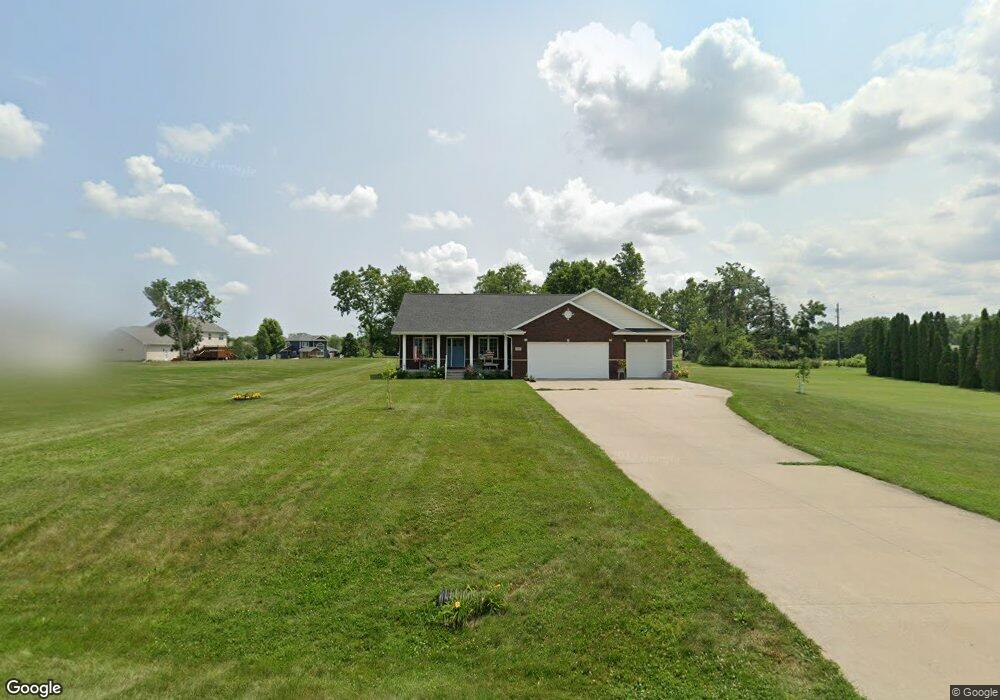
6395 Wayside Cir Cedar Rapids, IA 52411
Estimated Value: $386,000 - $468,483
3
Beds
2
Baths
1,829
Sq Ft
$241/Sq Ft
Est. Value
About This Home
This home is located at 6395 Wayside Cir, Cedar Rapids, IA 52411 and is currently estimated at $440,121, approximately $240 per square foot. 6395 Wayside Cir is a home located in Linn County with nearby schools including T.C. Cherry Elementary School, Viola Gibson Elementary School, and Ponderosa Elementary School.
Ownership History
Date
Name
Owned For
Owner Type
Purchase Details
Closed on
Apr 30, 2007
Sold by
Doyle Shawn P and Doyle Laure G
Bought by
Talyat Richard R and Talyat Diane M
Current Estimated Value
Home Financials for this Owner
Home Financials are based on the most recent Mortgage that was taken out on this home.
Original Mortgage
$185,000
Outstanding Balance
$112,591
Interest Rate
6.18%
Mortgage Type
Purchase Money Mortgage
Estimated Equity
$327,530
Purchase Details
Closed on
Jul 22, 2005
Sold by
Sturdivan Mervyn L and Mervyn L Sturdivan Trust
Bought by
Doyle Shawn P and Doyle Laure G
Home Financials for this Owner
Home Financials are based on the most recent Mortgage that was taken out on this home.
Original Mortgage
$115,000
Interest Rate
5.71%
Mortgage Type
Construction
Purchase Details
Closed on
Mar 15, 2000
Sold by
Manson Rodney E and Manson Jodi J
Bought by
Sturdivan Mervyn L
Purchase Details
Closed on
Mar 9, 2000
Sold by
Hoeger Dean B and Hoeger Cindy L
Bought by
Manson Rodney E and Manson Jodi J
Create a Home Valuation Report for This Property
The Home Valuation Report is an in-depth analysis detailing your home's value as well as a comparison with similar homes in the area
Home Values in the Area
Average Home Value in this Area
Purchase History
| Date | Buyer | Sale Price | Title Company |
|---|---|---|---|
| Talyat Richard R | $231,500 | None Available | |
| Doyle Shawn P | $52,000 | -- | |
| Sturdivan Mervyn L | $36,000 | -- | |
| Manson Rodney E | $30,500 | -- |
Source: Public Records
Mortgage History
| Date | Status | Borrower | Loan Amount |
|---|---|---|---|
| Open | Talyat Richard R | $185,000 | |
| Previous Owner | Doyle Shawn P | $115,000 |
Source: Public Records
Tax History Compared to Growth
Tax History
| Year | Tax Paid | Tax Assessment Tax Assessment Total Assessment is a certain percentage of the fair market value that is determined by local assessors to be the total taxable value of land and additions on the property. | Land | Improvement |
|---|---|---|---|---|
| 2025 | $3,614 | $364,100 | $65,000 | $299,100 |
| 2024 | $3,762 | $328,800 | $65,000 | $263,800 |
| 2023 | $3,762 | $328,800 | $65,000 | $263,800 |
| 2022 | $3,716 | $275,100 | $65,000 | $210,100 |
| 2021 | $3,812 | $275,100 | $65,000 | $210,100 |
| 2020 | $3,812 | $261,000 | $50,000 | $211,000 |
| 2019 | $3,492 | $244,700 | $50,000 | $194,700 |
| 2018 | $3,416 | $244,700 | $50,000 | $194,700 |
| 2017 | $3,550 | $243,400 | $50,000 | $193,400 |
| 2016 | $3,591 | $243,400 | $50,000 | $193,400 |
| 2015 | $3,615 | $243,400 | $50,000 | $193,400 |
| 2014 | $3,486 | $243,400 | $50,000 | $193,400 |
| 2013 | $3,414 | $243,400 | $50,000 | $193,400 |
Source: Public Records
Map
Nearby Homes
- 6524 Michael Dr NE
- 6718 Lauder Ln
- 6720 Caldwell Ln
- 6312 Casey Ln NE
- 6300 Westwind Rd
- 5843 Wells Ln
- 5854 Wells Ln
- 2492 River Run Rd
- 4301 Viola St NE
- 6505 Blairs Ferry Rd
- 5515 W Mustang Rd
- 2420 Heritage Green Dr
- 2255 Blairsferry Crossing
- 5180 Chestnut Valley Rd
- 225 Ridgewood Dr
- 4116 Whitewood Ct NE
- 4620 Prairie Stone Dr NE
- 4408 Prairie Stone Dr NE
- 4510 Prairie Stone Dr NE
- 6827 42nd St NE
- 6375 Wayside Cir
- 4600 Blairs Ferry Rd
- 6390 Wayside Cir
- 6275 Wayside Cir
- 4701 Blairs Ferry Rd NE
- 4707 Blairs Ferry Rd
- 6380 Wayside Cir
- 4701 Blairs Ferry Rd
- 6370 Wayside Cir
- 6215 Wayside Cir
- 6125 Wayside Cir
- 6035 Wayside Cir
- 4680 Leprechaun Ln
- 4660 Leprechaun Ln
- 6330 Wayside Cir
- 4720 Leprechaun Ln
- 6300 Wayside Cir
- 4600 Leprechaun Ln
- 6240 Wayside Cir
- 6060 Wayside Cir