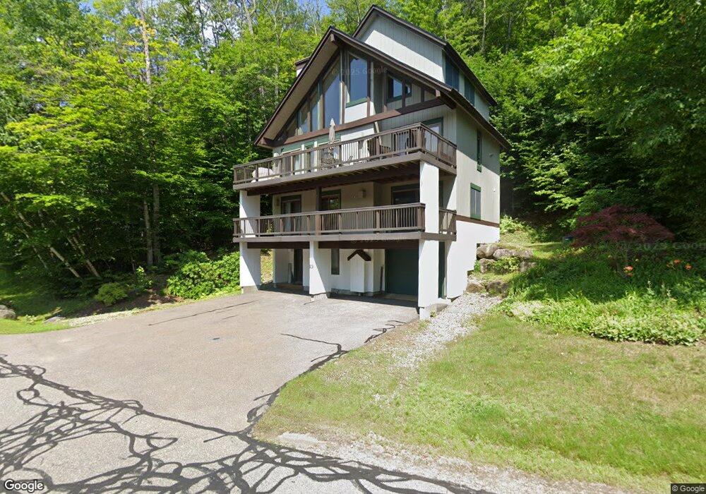
64 Westview Rd Unit 64 Lincoln, NH 03251
Estimated Value: $847,000 - $1,322,000
4
Beds
3
Baths
2,590
Sq Ft
$427/Sq Ft
Est. Value
About This Home
This home is located at 64 Westview Rd Unit 64, Lincoln, NH 03251 and is currently estimated at $1,104,713, approximately $426 per square foot. 64 Westview Rd Unit 64 is a home located in Grafton County with nearby schools including Lin-Wood Public Elementary School.
Ownership History
Date
Name
Owned For
Owner Type
Purchase Details
Closed on
Aug 27, 2018
Sold by
Jones Michael K and Jones Kristina L
Bought by
Barusso Tracy D and Brown Randall M
Current Estimated Value
Purchase Details
Closed on
Sep 19, 2017
Sold by
Kearney Ft and Kearney Christopher T
Bought by
Jones Michael K and Jones Kristina L
Home Financials for this Owner
Home Financials are based on the most recent Mortgage that was taken out on this home.
Original Mortgage
$424,100
Interest Rate
3.5%
Mortgage Type
Adjustable Rate Mortgage/ARM
Create a Home Valuation Report for This Property
The Home Valuation Report is an in-depth analysis detailing your home's value as well as a comparison with similar homes in the area
Home Values in the Area
Average Home Value in this Area
Purchase History
| Date | Buyer | Sale Price | Title Company |
|---|---|---|---|
| Barusso Tracy D | $274,000 | -- | |
| Jones Michael K | $535,000 | -- |
Source: Public Records
Mortgage History
| Date | Status | Borrower | Loan Amount |
|---|---|---|---|
| Previous Owner | Jones Michael K | $424,100 |
Source: Public Records
Tax History Compared to Growth
Tax History
| Year | Tax Paid | Tax Assessment Tax Assessment Total Assessment is a certain percentage of the fair market value that is determined by local assessors to be the total taxable value of land and additions on the property. | Land | Improvement |
|---|---|---|---|---|
| 2024 | $10,012 | $857,200 | $70,000 | $787,200 |
| 2023 | $10,012 | $857,200 | $70,000 | $787,200 |
| 2022 | $9,043 | $857,200 | $70,000 | $787,200 |
| 2021 | $9,035 | $857,200 | $70,000 | $787,200 |
| 2018 | $402,939 | $586,100 | $70,000 | $516,100 |
| 2016 | $7,731 | $586,100 | $70,000 | $516,100 |
| 2015 | $6,568 | $476,600 | $70,000 | $406,600 |
| 2014 | $6,577 | $476,600 | $70,000 | $406,600 |
| 2009 | -- | $516,680 | $0 | $516,680 |
Source: Public Records
Map
Nearby Homes
- 79 Flume Rd
- 57 W Branch Rd Unit 7
- 39.17 S Peak Rd
- 39.16 S Peak Rd
- 139 S Peak Rd
- 227 S Peak Rd
- 26 Fox Run Rd Unit 2&3
- 10 Potash Rd Unit 3
- 90 Loon Mountain Rd Unit 1021D
- 90 Loon Mountain Rd Unit 1307C
- 90 Loon Mountain Rd Unit 1034C
- 90 Loon Mountain Rd Unit 1165 A-D
- 90 Loon Mountain Rd Unit 1205B
- 90 Loon Mountain Rd Unit 1303D
- 90 Loon Mountain Rd Unit 1053A
- 90 Loon Mountain Rd Unit 1161C
- 90 Loon Mountain Rd Unit 1325D
- 90 Loon Mountain Rd Unit 1126C
- 90 Loon Mountain Rd Unit 861D
- 90 Loon Mountain Rd Unit 1021A
- 64 Westview Rd
- #64 Westview Rd Unit 64
- 69 (78) Blueberry Rd
- 3 Blueberry Rd
- 68 Westview Rd
- 70 Westview Rd Unit 70
- 59 Westview Rd Unit 1
- 51 69(70) Westview - Coolidge Falls
- 25 Bridgeview Rd
- 54 Westview Rd
- 51 Westview Rd
- 52 Westview Rd
- 99 Flume Rd Unit 99
- 108 Flume Rd
- 50 Westview Rd
- Lot 093 Flume Rd
- 10 Blackberry Rd
- 48 Westview Rd Unit B
- 48 Westview Rd
- 47 Westview Rd Unit 86