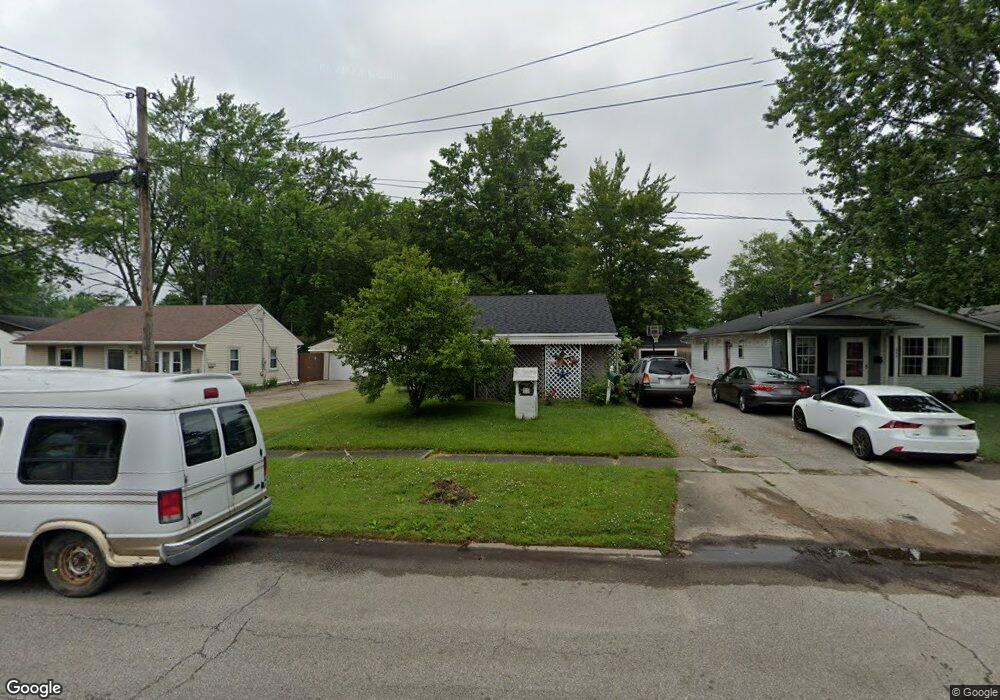
642 Case Ave Elyria, OH 44035
Estimated Value: $134,171 - $164,000
3
Beds
1
Bath
1,042
Sq Ft
$143/Sq Ft
Est. Value
About This Home
This home is located at 642 Case Ave, Elyria, OH 44035 and is currently estimated at $148,793, approximately $142 per square foot. 642 Case Ave is a home located in Lorain County with nearby schools including Eastern Heights Middle School, Elyria High School, and Constellation Schools: Elyria Community Elementary.
Ownership History
Date
Name
Owned For
Owner Type
Purchase Details
Closed on
Oct 6, 2016
Sold by
Destination Dessert Ltd
Bought by
Dennis Donald G
Current Estimated Value
Purchase Details
Closed on
Feb 19, 2012
Sold by
Dennis Donald G
Bought by
Destination Dessert Llc
Purchase Details
Closed on
Jun 4, 2003
Sold by
Booth Thomas A and Booth Terri J
Bought by
Dennis Donald G
Home Financials for this Owner
Home Financials are based on the most recent Mortgage that was taken out on this home.
Original Mortgage
$82,800
Interest Rate
5.71%
Mortgage Type
Purchase Money Mortgage
Purchase Details
Closed on
Jan 24, 2001
Sold by
Booth Thomas A
Bought by
Booth Thomas A and Booth Terri J
Purchase Details
Closed on
Jul 8, 1999
Sold by
Booth Sharon K
Bought by
Booth Thomas A
Create a Home Valuation Report for This Property
The Home Valuation Report is an in-depth analysis detailing your home's value as well as a comparison with similar homes in the area
Home Values in the Area
Average Home Value in this Area
Purchase History
| Date | Buyer | Sale Price | Title Company |
|---|---|---|---|
| Dennis Donald G | $58,700 | -- | |
| Destination Dessert Llc | -- | None Available | |
| Dennis Donald G | $103,500 | Ohio Clear Title Agency | |
| Booth Thomas A | -- | First Ohio Title Services In | |
| Booth Thomas A | -- | -- |
Source: Public Records
Mortgage History
| Date | Status | Borrower | Loan Amount |
|---|---|---|---|
| Previous Owner | Dennis Donald G | $82,800 |
Source: Public Records
Tax History
| Year | Tax Paid | Tax Assessment Tax Assessment Total Assessment is a certain percentage of the fair market value that is determined by local assessors to be the total taxable value of land and additions on the property. | Land | Improvement |
|---|---|---|---|---|
| 2024 | $991 | $30,737 | $7,196 | $23,541 |
| 2023 | $854 | $24,850 | $5,814 | $19,037 |
| 2022 | $874 | $24,850 | $5,814 | $19,037 |
| 2021 | $876 | $24,850 | $5,810 | $19,040 |
| 2020 | $679 | $19,450 | $4,550 | $14,900 |
| 2019 | $651 | $19,450 | $4,550 | $14,900 |
| 2018 | $423 | $19,450 | $4,550 | $14,900 |
| 2017 | $1,305 | $20,540 | $4,610 | $15,930 |
| 2016 | $1,321 | $20,540 | $4,610 | $15,930 |
| 2015 | $1,239 | $20,540 | $4,610 | $15,930 |
| 2014 | $1,272 | $21,330 | $4,790 | $16,540 |
| 2013 | $1,261 | $21,330 | $4,790 | $16,540 |
Source: Public Records
Map
Nearby Homes
- 549 Delaware Ave
- 523 Purdue Ave
- 1210 Prospect St
- 817 Boston Ave
- 832 S Logan St
- 800 Boston Ave
- 914 Garford Ave
- 539 Princeton Ave
- 340 Boston Ave
- 148 Bentley Dr Unit 25
- 154 Bentley Dr
- 337 University Ave
- 708 Park Ave
- 453 Kenyon Ave
- 459 Auburn St
- 247 Georgia Ave
- 246 Syracuse Ct
- 310 Carol Ln
- 418 Carol Ln
- 355 Kenyon Ave
Your Personal Tour Guide
Ask me questions while you tour the home.