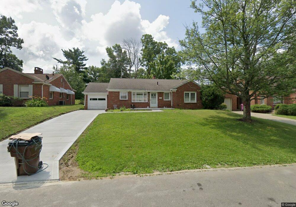
643 Barnard Ave Mansfield, OH 44903
Estimated Value: $137,000 - $171,000
3
Beds
2
Baths
1,249
Sq Ft
$120/Sq Ft
Est. Value
About This Home
This home is located at 643 Barnard Ave, Mansfield, OH 44903 and is currently estimated at $149,642, approximately $119 per square foot. 643 Barnard Ave is a home located in Richland County with nearby schools including Discovery School and St. Peter's Junior High / High School.
Ownership History
Date
Name
Owned For
Owner Type
Purchase Details
Closed on
Apr 20, 2010
Sold by
Citimortgage Inc
Bought by
Stimens Kurt
Current Estimated Value
Purchase Details
Closed on
Feb 19, 2010
Sold by
Eith Raymond C
Bought by
Citimortgage Inc
Purchase Details
Closed on
Oct 1, 1986
Create a Home Valuation Report for This Property
The Home Valuation Report is an in-depth analysis detailing your home's value as well as a comparison with similar homes in the area
Home Values in the Area
Average Home Value in this Area
Purchase History
| Date | Buyer | Sale Price | Title Company |
|---|---|---|---|
| Stimens Kurt | $39,000 | Attorney | |
| Citimortgage Inc | $46,000 | None Available | |
| -- | $52,000 | -- |
Source: Public Records
Tax History
| Year | Tax Paid | Tax Assessment Tax Assessment Total Assessment is a certain percentage of the fair market value that is determined by local assessors to be the total taxable value of land and additions on the property. | Land | Improvement |
|---|---|---|---|---|
| 2024 | $1,398 | $29,190 | $4,980 | $24,210 |
| 2023 | $1,398 | $29,190 | $4,980 | $24,210 |
| 2022 | $1,182 | $20,690 | $4,270 | $16,420 |
| 2021 | $1,190 | $20,690 | $4,270 | $16,420 |
| 2020 | $1,217 | $20,690 | $4,270 | $16,420 |
| 2019 | $1,349 | $20,690 | $4,270 | $16,420 |
| 2018 | $1,331 | $20,690 | $4,270 | $16,420 |
| 2017 | $1,148 | $20,690 | $4,270 | $16,420 |
| 2016 | $1,001 | $15,500 | $5,700 | $9,800 |
| 2015 | $1,001 | $15,500 | $5,700 | $9,800 |
| 2014 | $943 | $15,500 | $5,700 | $9,800 |
| 2012 | $361 | $15,500 | $5,700 | $9,800 |
Source: Public Records
Map
Nearby Homes
- 679 Coleman Rd
- 616 Cline Ave
- 455 Marion Ave
- 189 Westwood Ave
- 487 Davey Ave
- 133 Stewart Ave S
- 143 Fairlawn Ave
- 116 Stewart Ave S
- 135 Fairlawn Ave
- 108 Stewart Ave S
- 129 Fairlawn Ave
- 356 S Linden Rd
- 282 Vennum Ave
- 24 Stewart Ave S
- 158 Vennum Ave
- 960 W Linden Cir
- 31 Bartley Ave
- 232 S Trimble Rd Unit 234
- 244 S Trimble Rd Unit 246
- 655 Woodhill Rd
- 653 Barnard Ave
- 637 Barnard Ave
- 0 Barnard Ave
- 657 Barnard Ave
- 631 Barnard Ave
- 644 Manchester Rd
- 638 Manchester Rd
- 650 Manchester Rd
- 632 Manchester Rd
- 644 Barnard Ave
- 654 Manchester Rd
- 650 Barnard Ave
- 625 Barnard Ave
- 626 Manchester Rd
- 638 Barnard Ave
- 661 Barnard Ave
- 628 Barnard Ave
- 660 Manchester Rd
- 624 Barnard Ave
- 620 Manchester Rd
Your Personal Tour Guide
Ask me questions while you tour the home.