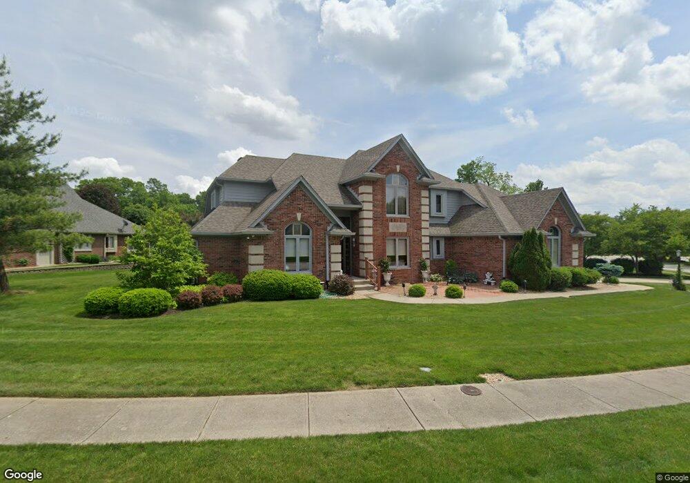
6439 Forrest Commons Blvd Indianapolis, IN 46227
Linden Wood NeighborhoodEstimated Value: $436,000 - $482,000
3
Beds
3
Baths
2,887
Sq Ft
$158/Sq Ft
Est. Value
About This Home
This home is located at 6439 Forrest Commons Blvd, Indianapolis, IN 46227 and is currently estimated at $454,745, approximately $157 per square foot. 6439 Forrest Commons Blvd is a home located in Marion County with nearby schools including William Henry Burkhart Elementary School, Perry Meridian 6th Grade Academy, and Perry Meridian Middle School.
Ownership History
Date
Name
Owned For
Owner Type
Purchase Details
Closed on
Nov 14, 2017
Sold by
Rynard Dorothy A
Bought by
Robert L Rynard and Dorothy A Rynard
Current Estimated Value
Purchase Details
Closed on
Aug 22, 2013
Sold by
Mccormick John J
Bought by
Rynard Dorothy A
Purchase Details
Closed on
Aug 15, 2013
Sold by
Mccormick John J
Bought by
Rynard Dorothy A
Create a Home Valuation Report for This Property
The Home Valuation Report is an in-depth analysis detailing your home's value as well as a comparison with similar homes in the area
Home Values in the Area
Average Home Value in this Area
Purchase History
| Date | Buyer | Sale Price | Title Company |
|---|---|---|---|
| Robert L Rynard | -- | -- | |
| Rynard Dorothy A | -- | -- | |
| Rynard Dorothy A | $250,000 | -- |
Source: Public Records
Tax History Compared to Growth
Tax History
| Year | Tax Paid | Tax Assessment Tax Assessment Total Assessment is a certain percentage of the fair market value that is determined by local assessors to be the total taxable value of land and additions on the property. | Land | Improvement |
|---|---|---|---|---|
| 2024 | $5,677 | $422,700 | $65,800 | $356,900 |
| 2023 | $5,677 | $429,200 | $65,800 | $363,400 |
| 2022 | $5,294 | $390,300 | $65,800 | $324,500 |
| 2021 | $5,125 | $372,300 | $65,800 | $306,500 |
| 2020 | $4,299 | $311,000 | $65,800 | $245,200 |
| 2019 | $4,174 | $300,400 | $57,200 | $243,200 |
| 2018 | $3,840 | $279,900 | $57,200 | $222,700 |
| 2017 | $3,758 | $273,800 | $57,200 | $216,600 |
| 2016 | $3,671 | $267,400 | $57,200 | $210,200 |
| 2014 | $3,390 | $277,300 | $57,200 | $220,100 |
| 2013 | $3,267 | $273,100 | $57,200 | $215,900 |
Source: Public Records
Map
Nearby Homes
- 6520 Forrest Commons Blvd
- 27 Forrests Edge Ct
- 20 Forrests Edge Ct
- 6712 Forrest Commons Blvd
- 6725 Robin Hood Ct
- 26 W Loretta Dr
- 6643 S New Jersey St
- 128 Dahlia Ln
- 136 W Loretta Dr
- 6630 S Meridian St
- 115 Jordan Rd
- 212 Tamara Trail
- 302 E Brunswick Ave
- 410 E Southport Rd
- 402 W Banta Rd
- 50 Charing Cross Rd
- 418 E Beechwood Ln
- 667 E Edgewood Ave
- 302 W Edgewood Ave
- 232 Bangor Dr
- 6433 Forrest Commons Blvd
- 132 E Banta Rd
- 6420 Forrest Commons Blvd
- 6416 King James Ct
- 6446 Forrest Commons Blvd
- 6427 Forrest Commons Blvd
- 6454 Forrest Commons Blvd
- 142 E Banta Rd
- 6414 Forrest Commons Blvd
- 6411 King James Ct
- 6410 King James Ct
- 6521 Forrest Commons Blvd
- 6421 Forrest Commons Blvd
- 133 E Banta Rd
- 206 E Banta Rd
- 54 E Banta Rd
- 143 E Banta Rd
- 6408 Forrest Commons Blvd
- 6405 King James Ct
- 6404 King James Ct