Estimated Value: $274,098 - $312,000
3
Beds
2
Baths
1,195
Sq Ft
$244/Sq Ft
Est. Value
About This Home
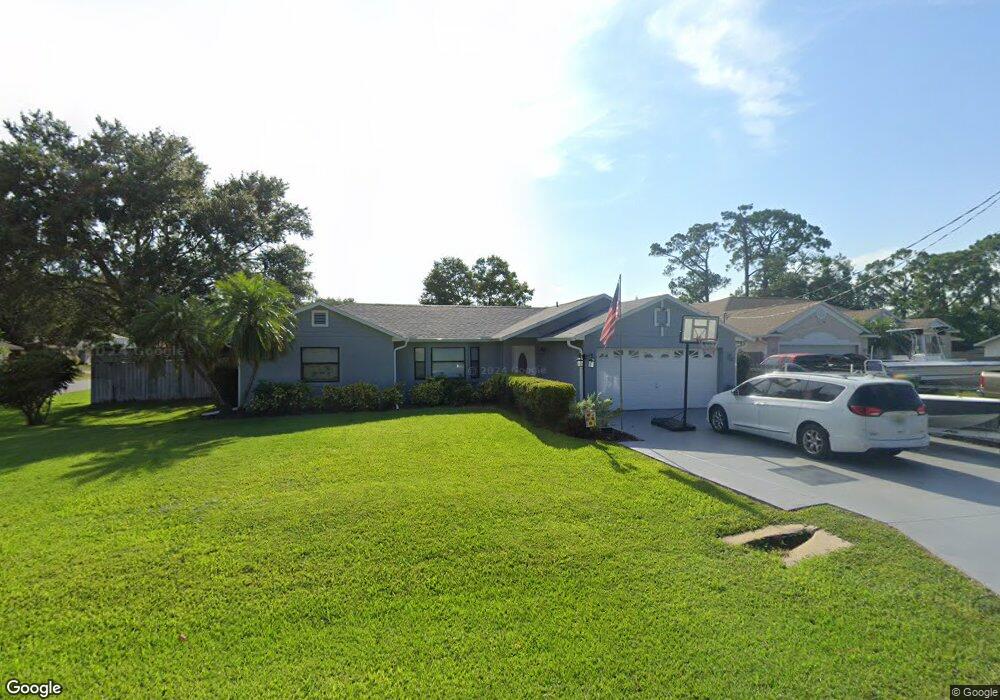
This home is located at 6550 Bancroft Ave, Cocoa, FL 32927 and is currently estimated at $291,025, approximately $243 per square foot. 6550 Bancroft Ave is a home located in Brevard County with nearby schools including Enterprise Elementary School, Space Coast Junior/Senior High School, and East Atlantic Prep of Brevard County.
Ownership History
Date
Name
Owned For
Owner Type
Purchase Details
Closed on
Dec 20, 2021
Sold by
Prine Sr James H
Bought by
Griffin Lloyd B and Griffin Chelsea
Current Estimated Value
Home Financials for this Owner
Home Financials are based on the most recent Mortgage that was taken out on this home.
Original Mortgage
$253,250
Outstanding Balance
$232,955
Interest Rate
3.12%
Mortgage Type
New Conventional
Estimated Equity
$58,070
Purchase Details
Closed on
Oct 11, 2002
Sold by
Osborn Williard L and Osborn Pamela K
Bought by
Liikala Dale P
Home Financials for this Owner
Home Financials are based on the most recent Mortgage that was taken out on this home.
Original Mortgage
$75,600
Interest Rate
6.18%
Mortgage Type
Purchase Money Mortgage
Purchase Details
Closed on
Mar 27, 1996
Sold by
Fowler Michelle D and Abbott Michelle D
Bought by
Osborn Willard L and Osborn Pamela K
Create a Home Valuation Report for This Property
The Home Valuation Report is an in-depth analysis detailing your home's value as well as a comparison with similar homes in the area
Home Values in the Area
Average Home Value in this Area
Purchase History
| Date | Buyer | Sale Price | Title Company |
|---|---|---|---|
| Griffin Lloyd B | $273,300 | New Title Company Name | |
| Liikala Dale P | $94,500 | -- | |
| Osborn Willard L | $72,000 | -- |
Source: Public Records
Mortgage History
| Date | Status | Borrower | Loan Amount |
|---|---|---|---|
| Open | Griffin Lloyd B | $253,250 | |
| Previous Owner | Liikala Dale P | $75,600 |
Source: Public Records
Tax History
| Year | Tax Paid | Tax Assessment Tax Assessment Total Assessment is a certain percentage of the fair market value that is determined by local assessors to be the total taxable value of land and additions on the property. | Land | Improvement |
|---|---|---|---|---|
| 2025 | $2,532 | $199,870 | -- | -- |
| 2024 | $2,492 | $194,240 | -- | -- |
| 2023 | $2,492 | $188,590 | $0 | $0 |
| 2022 | $2,331 | $183,100 | $0 | $0 |
| 2021 | $943 | $65,110 | $0 | $0 |
| 2020 | $897 | $64,220 | $0 | $0 |
| 2019 | $845 | $62,780 | $0 | $0 |
| 2018 | $846 | $61,610 | $0 | $0 |
| 2017 | $835 | $58,570 | $0 | $0 |
| 2016 | $841 | $57,370 | $18,000 | $39,370 |
| 2015 | $846 | $56,980 | $15,000 | $41,980 |
| 2014 | $851 | $56,530 | $11,000 | $45,530 |
Source: Public Records
Map
Nearby Homes
- 6581 Bancroft Ave
- 6481 La Brea Ave
- 6643 Emil Ave
- 5721 Beaverbrook St
- 6615 Dock Ave
- 5680 Banos Ave
- 6438 Hudson Rd
- 5601 Banos Ave
- 6460 Ainsworth Rd
- 6450 Ember Ave
- 0 Aruin St Unit 1222557
- 6760 Cairo Rd
- 5555 Brandon St
- 6815 Bryant Rd
- 5680 Brandon St
- 6460 Homestead Ave
- 6545 Addie Ave
- 00 Unknown
- 23-35-21-JX-B-2 Aruin St
- 7065 Hundred Acre Dr
- 6560 Bancroft Ave
- 6553 Emil Ave
- 6563 Emil Ave
- 5565 Curtis Blvd
- 6570 Bancroft Ave
- 5555 Curtis Blvd
- 6561 Bancroft Ave
- 6573 Emil Ave
- 5585 Curtis Blvd
- 6571 Bancroft Ave
- 6580 Bancroft Ave
- 5539 Curtis Blvd
- 6583 Emil Ave
- 5530 Curtis Blvd
- 6552 Emil Ave
- 5615 Curtis Blvd
- 6562 Emil Ave
- 6564 Haven Ave
- 6590 Bancroft Ave
- 5590 Fairbridge St
Your Personal Tour Guide
Ask me questions while you tour the home.