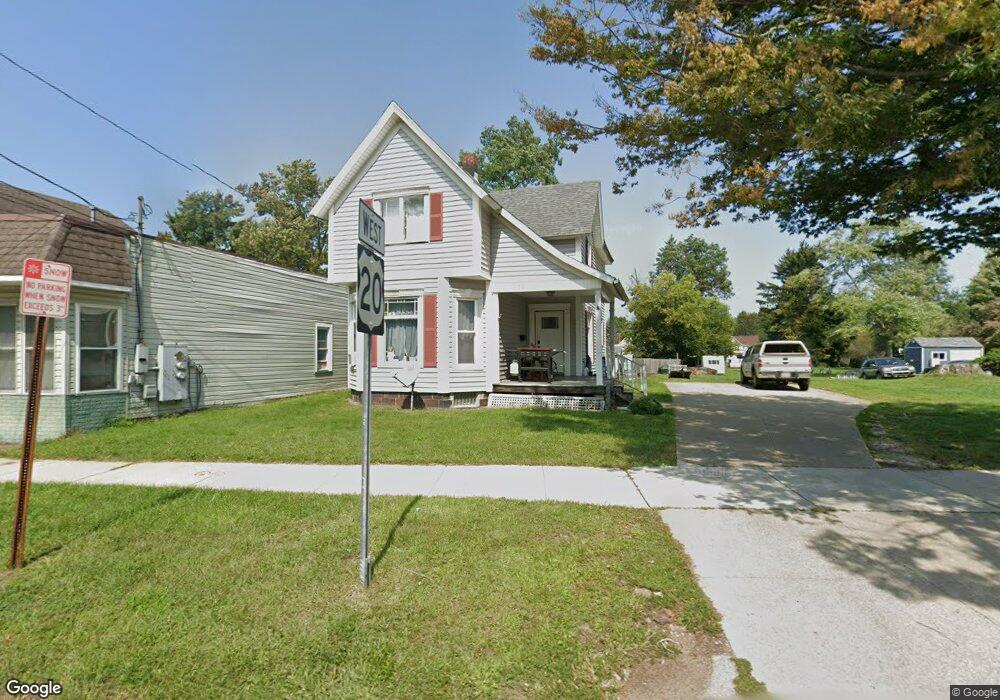
656 Main St Conneaut, OH 44030
Estimated Value: $74,000 - $102,977
3
Beds
2
Baths
1,592
Sq Ft
$59/Sq Ft
Est. Value
About This Home
This home is located at 656 Main St, Conneaut, OH 44030 and is currently estimated at $93,494, approximately $58 per square foot. 656 Main St is a home located in Ashtabula County with nearby schools including Lakeshore Primary Elementary School, Gateway Elementary School, and Conneaut Middle School.
Ownership History
Date
Name
Owned For
Owner Type
Purchase Details
Closed on
Oct 7, 2010
Sold by
Secretary Of Housing & Urban Development
Bought by
Rozalski Charles J and Rozalski Bonnie L
Current Estimated Value
Purchase Details
Closed on
Sep 28, 2009
Sold by
Everhome Mortgage Company
Bought by
Secretary Of Housing & Urban Development
Purchase Details
Closed on
Sep 2, 2009
Sold by
Bogart Duane L and Bogart Duane
Bought by
Everhome Mortgage Company
Purchase Details
Closed on
Aug 30, 2005
Sold by
Bogart Mona L
Bought by
Bogart Duane L
Purchase Details
Closed on
Feb 7, 2003
Sold by
Poplin Randall L and Poplin Kathy M
Bought by
Bogart Duane and Bogart Mona
Home Financials for this Owner
Home Financials are based on the most recent Mortgage that was taken out on this home.
Original Mortgage
$84,671
Interest Rate
5.3%
Mortgage Type
FHA
Create a Home Valuation Report for This Property
The Home Valuation Report is an in-depth analysis detailing your home's value as well as a comparison with similar homes in the area
Home Values in the Area
Average Home Value in this Area
Purchase History
| Date | Buyer | Sale Price | Title Company |
|---|---|---|---|
| Rozalski Charles J | $27,000 | Lakeside Title & Escrow Agen | |
| Secretary Of Housing & Urban Development | -- | None Available | |
| Everhome Mortgage Company | $58,000 | None Available | |
| Bogart Duane L | -- | -- | |
| Bogart Duane | $86,000 | Netwide Title Agency |
Source: Public Records
Mortgage History
| Date | Status | Borrower | Loan Amount |
|---|---|---|---|
| Previous Owner | Bogart Duane | $84,671 |
Source: Public Records
Tax History Compared to Growth
Tax History
| Year | Tax Paid | Tax Assessment Tax Assessment Total Assessment is a certain percentage of the fair market value that is determined by local assessors to be the total taxable value of land and additions on the property. | Land | Improvement |
|---|---|---|---|---|
| 2024 | $1,511 | $20,660 | $2,070 | $18,590 |
| 2023 | $982 | $20,660 | $2,070 | $18,590 |
| 2022 | $859 | $15,900 | $1,580 | $14,320 |
| 2021 | $873 | $15,900 | $1,580 | $14,320 |
| 2020 | $873 | $15,900 | $1,580 | $14,320 |
| 2019 | $672 | $11,980 | $1,090 | $10,890 |
| 2018 | $641 | $11,980 | $1,090 | $10,890 |
| 2017 | $640 | $11,980 | $1,090 | $10,890 |
| 2016 | $853 | $17,470 | $1,580 | $15,890 |
| 2015 | $1,664 | $17,470 | $1,580 | $15,890 |
| 2014 | $1,720 | $17,470 | $1,580 | $15,890 |
| 2013 | $967 | $21,700 | $1,750 | $19,950 |
Source: Public Records
Map
Nearby Homes
- 589 Main St
- 536 Madison St
- 247 Whitney St
- 455 Main St
- 855 Spring St Unit S9
- 474 Sherman St
- 251 St Rt 7
- 429 Depot St
- 18 Hillcrest Ct
- 459 Mill St
- 405 Bliss Ave
- 0 Chestnut St Unit 5120761
- 375 Bliss Ave
- 536 Mill St
- 402 Broad St
- 408 Broad State Rd 7 St
- 289 Harbor St
- 386 Washington St
- 413 Harbor St
- 179 Marshall St