Estimated Value: $328,000 - $354,000
4
Beds
4
Baths
2,180
Sq Ft
$157/Sq Ft
Est. Value
About This Home
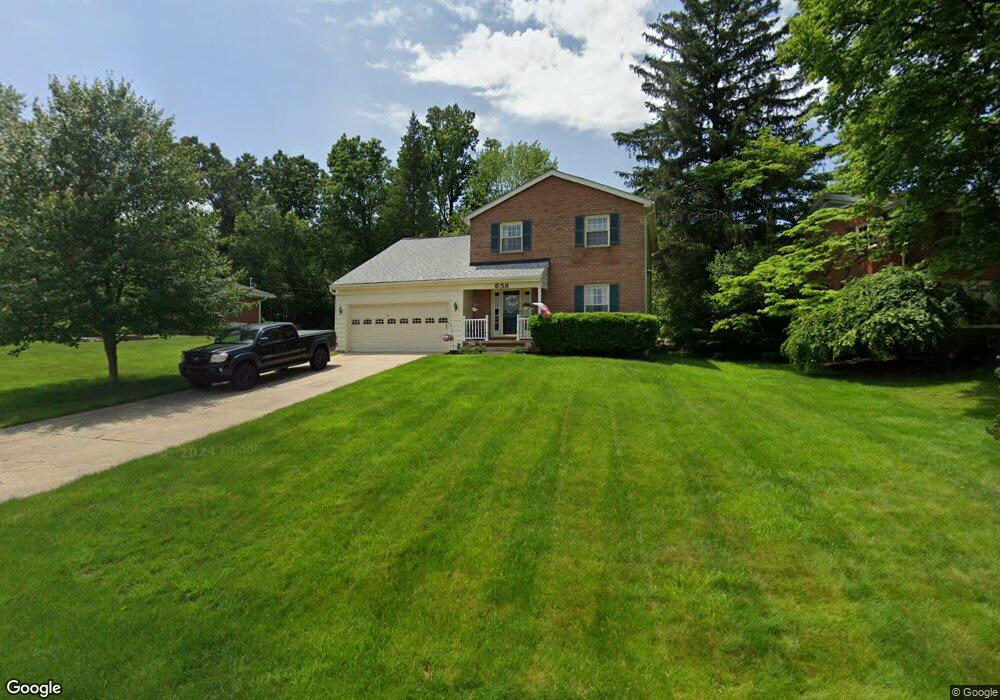
This home is located at 658 Moorfield Rd, Akron, OH 44333 and is currently estimated at $342,246, approximately $156 per square foot. 658 Moorfield Rd is a home located in Summit County with nearby schools including Copley-Fairlawn Middle School, Copley High School, and Fairlawn Lutheran School.
Ownership History
Date
Name
Owned For
Owner Type
Purchase Details
Closed on
Apr 10, 1995
Sold by
Pastor Fleeta R
Bought by
Moloney Thomas P and Moloney Diane
Current Estimated Value
Home Financials for this Owner
Home Financials are based on the most recent Mortgage that was taken out on this home.
Original Mortgage
$101,000
Interest Rate
8.79%
Mortgage Type
New Conventional
Create a Home Valuation Report for This Property
The Home Valuation Report is an in-depth analysis detailing your home's value as well as a comparison with similar homes in the area
Home Values in the Area
Average Home Value in this Area
Purchase History
| Date | Buyer | Sale Price | Title Company |
|---|---|---|---|
| Moloney Thomas P | $131,500 | -- |
Source: Public Records
Mortgage History
| Date | Status | Borrower | Loan Amount |
|---|---|---|---|
| Previous Owner | Moloney Thomas P | $101,000 |
Source: Public Records
Tax History Compared to Growth
Tax History
| Year | Tax Paid | Tax Assessment Tax Assessment Total Assessment is a certain percentage of the fair market value that is determined by local assessors to be the total taxable value of land and additions on the property. | Land | Improvement |
|---|---|---|---|---|
| 2025 | $3,685 | $92,687 | $18,053 | $74,634 |
| 2024 | $3,685 | $92,687 | $18,053 | $74,634 |
| 2023 | $3,685 | $92,687 | $18,053 | $74,634 |
| 2022 | $3,650 | $75,975 | $14,798 | $61,177 |
| 2021 | $3,429 | $75,975 | $14,798 | $61,177 |
| 2020 | $3,352 | $75,980 | $14,800 | $61,180 |
| 2019 | $3,103 | $62,880 | $13,210 | $49,670 |
| 2018 | $3,040 | $62,880 | $13,210 | $49,670 |
| 2017 | $3,240 | $62,880 | $13,210 | $49,670 |
| 2016 | $3,240 | $62,880 | $13,210 | $49,670 |
| 2015 | $3,240 | $62,880 | $13,210 | $49,670 |
| 2014 | $3,228 | $62,880 | $13,210 | $49,670 |
| 2013 | $3,220 | $62,880 | $13,210 | $49,670 |
Source: Public Records
Map
Nearby Homes
- 595 Moorfield Rd
- 2385 Covington Rd Unit 402
- 2375 Covington Rd Unit 311
- 2445 Chatham Rd
- 288 Kenridge Rd
- 2520 Holgate Rd
- 177 Caladonia Ave
- 342 S Miller Rd
- 135 Southwood Rd
- 2595 Sand Run Pkwy
- 320 Caladonia Ave
- 441 Sandhurst Rd
- 48 S Wheaton Rd
- 128 Overwood Rd
- 47 S Wheaton Rd
- 2239 Woodpark Rd
- 3081 Bancroft Rd
- 2267 Woodpark Rd
- 257 Sand Run Rd
- 3143 Morewood Rd
- 668 Moorfield Rd
- 646 Moorfield Rd
- 664 Hampshire Rd
- 670 Hampshire Rd
- 639 Moorfield Rd
- 0 Moorfield Rd
- 640 Hampshire Rd
- 684 Hampshire Rd
- 630 Moorfield Rd
- 667 Hampshire Rd
- 630 Hampshire Rd
- 655 Hampshire Rd
- 673 Hampshire Rd
- 622 Moorfield Rd
- 679 Hampshire Rd
- 615 Moorfield Rd
- 616 Hampshire Rd
- 633 Hampshire Rd
- V/L Hampshire Rd
- 693 V/L Hampshire Rd