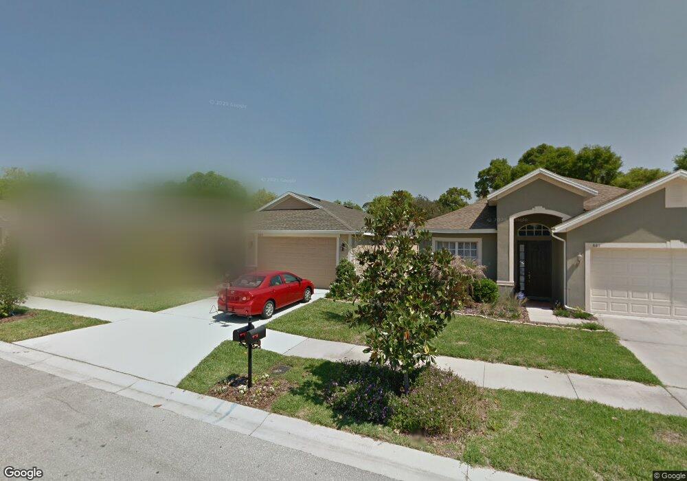
659 Breezeway Ct Brandon, FL 33511
Estimated Value: $351,587 - $403,000
4
Beds
2
Baths
1,851
Sq Ft
$207/Sq Ft
Est. Value
About This Home
This home is located at 659 Breezeway Ct, Brandon, FL 33511 and is currently estimated at $383,397, approximately $207 per square foot. 659 Breezeway Ct is a home located in Hillsborough County with nearby schools including Kingswood Elementary School, Rodgers Middle School, and Bloomingdale High School.
Ownership History
Date
Name
Owned For
Owner Type
Purchase Details
Closed on
Sep 12, 2011
Sold by
Northrup George L and Northrup Grace L
Bought by
Northrup Family Living Trust
Current Estimated Value
Purchase Details
Closed on
Jun 30, 2010
Sold by
D R Horton Inc
Bought by
Northrup George L and Northrup Grace L
Home Financials for this Owner
Home Financials are based on the most recent Mortgage that was taken out on this home.
Original Mortgage
$98,094
Interest Rate
4.77%
Mortgage Type
New Conventional
Create a Home Valuation Report for This Property
The Home Valuation Report is an in-depth analysis detailing your home's value as well as a comparison with similar homes in the area
Home Values in the Area
Average Home Value in this Area
Purchase History
| Date | Buyer | Sale Price | Title Company |
|---|---|---|---|
| Northrup Family Living Trust | -- | None Available | |
| Northrup George L | $198,094 | Dhi Title Of Florida Inc |
Source: Public Records
Mortgage History
| Date | Status | Borrower | Loan Amount |
|---|---|---|---|
| Previous Owner | Northrup George L | $98,094 |
Source: Public Records
Tax History
| Year | Tax Paid | Tax Assessment Tax Assessment Total Assessment is a certain percentage of the fair market value that is determined by local assessors to be the total taxable value of land and additions on the property. | Land | Improvement |
|---|---|---|---|---|
| 2025 | $3,033 | $165,892 | -- | -- |
| 2024 | $3,033 | $161,217 | -- | -- |
| 2023 | $2,917 | $156,521 | $0 | $0 |
| 2022 | $2,955 | $151,962 | $0 | $0 |
| 2021 | $2,867 | $147,536 | $0 | $0 |
| 2020 | $2,783 | $145,499 | $0 | $0 |
| 2019 | $2,689 | $142,228 | $0 | $0 |
| 2018 | $2,636 | $139,576 | $0 | $0 |
| 2017 | $2,600 | $153,594 | $0 | $0 |
| 2016 | $2,536 | $133,893 | $0 | $0 |
| 2015 | $2,524 | $132,962 | $0 | $0 |
| 2014 | $2,524 | $131,907 | $0 | $0 |
| 2013 | $2,525 | $129,958 | $0 | $0 |
Source: Public Records
Map
Nearby Homes
- 607 Center Ave
- 651 Breezeway Ct
- 4104 Maywood Dr
- 4234 Alafia Blvd
- 212 Excalibur Ct
- 4162 Alafia Blvd
- 291 Mossy River Ct
- 0 Revels Rd
- 645 Pine Forest Dr
- 821 Lucent Sands Ct
- 3829 Rippaso Place
- 6924 Valrie Ln
- 1204 Davies Rd
- 3801 Southview Dr
- 155 Sabal Breeze Ct
- 6906 Valrie Ln
- 3908 Alafia Blvd
- 3727 Coppertree Cir
- 3806 Pinedale St
- 931 Estelle Ave
- 661 Breezeway Ct
- 657 Breezeway Ct
- 663 Breezeway Ct
- 655 Breezeway Ct
- 4043 Forecast Dr
- 4045 Forecast Dr
- 4041 Forecast Dr
- 4047 Forecast Dr
- 4039 Forecast Dr
- 653 Breezeway Ct
- 665 Breezeway Ct
- 656 Breezeway Ct
- 4049 Forecast Dr
- 658 Breezeway Ct
- 654 Breezeway Ct
- 4037 Forecast Dr
- 660 Breezeway Ct
- 4051 Forecast Dr
- 662 Breezeway Ct
- 603 Center Ave
Your Personal Tour Guide
Ask me questions while you tour the home.