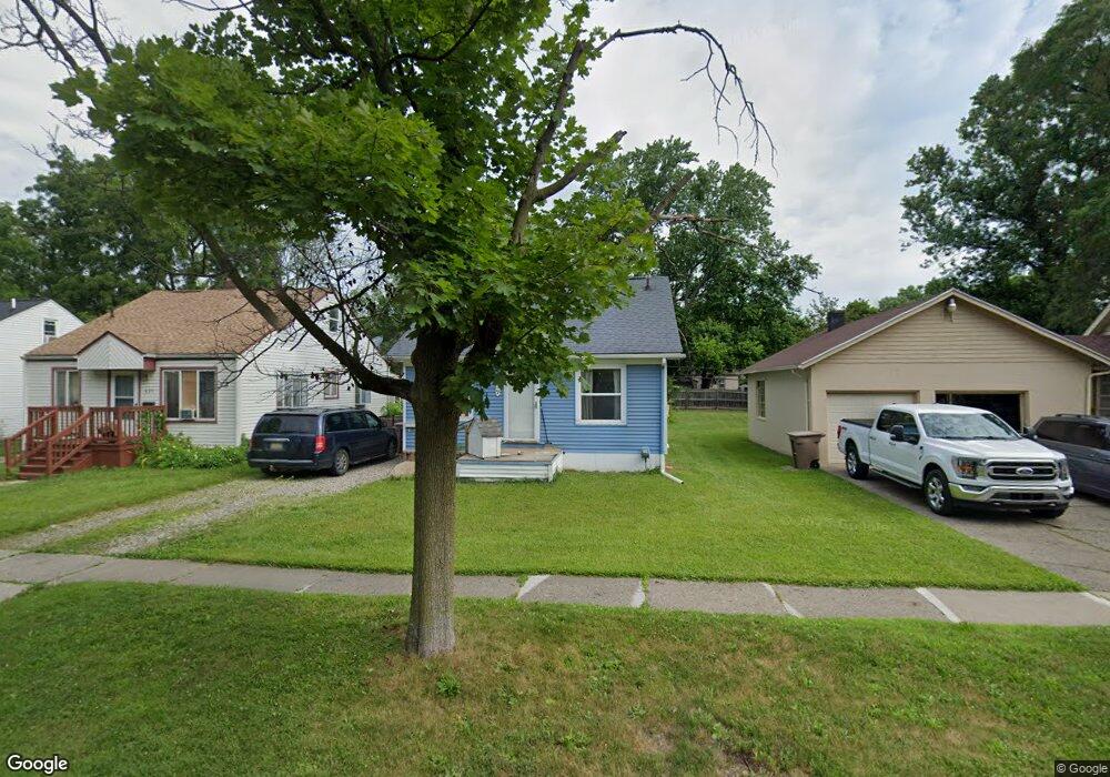
659 E Mansfield Ave Pontiac, MI 48340
Estimated Value: $111,090 - $159,000
3
Beds
1
Bath
750
Sq Ft
$179/Sq Ft
Est. Value
About This Home
This home is located at 659 E Mansfield Ave, Pontiac, MI 48340 and is currently estimated at $134,023, approximately $178 per square foot. 659 E Mansfield Ave is a home located in Oakland County with nearby schools including Owen Elementary School, Pontiac Middle School, and Pontiac High School.
Ownership History
Date
Name
Owned For
Owner Type
Purchase Details
Closed on
Sep 13, 2021
Sold by
Wilder Mitchell E
Bought by
Wilder Steve and Wilder Mitchell E
Current Estimated Value
Purchase Details
Closed on
Jan 11, 2008
Sold by
Rose Grover C
Bought by
Wilder Mitchell E
Purchase Details
Closed on
Dec 13, 2007
Sold by
Harper Christian A
Bought by
Rose Grover C
Purchase Details
Closed on
Mar 15, 1978
Sold by
Brower Flora N and Wagner Galon W
Bought by
Harper Wilma J
Purchase Details
Closed on
Jul 8, 1966
Sold by
Harper Don P
Bought by
Harper Wilma J
Create a Home Valuation Report for This Property
The Home Valuation Report is an in-depth analysis detailing your home's value as well as a comparison with similar homes in the area
Home Values in the Area
Average Home Value in this Area
Purchase History
| Date | Buyer | Sale Price | Title Company |
|---|---|---|---|
| Wilder Steve | -- | Philip R Seaver Title Co Inc | |
| Wilder Mitchell E | $12,000 | Philip R Seaver Title Co Inc | |
| Rose Grover C | $6,000 | Philip R Seaver Title Co Inc | |
| Harper Wilma J | $10,000 | Stewart Title Guaranty Compa | |
| Harper Wilma J | -- | Multiple |
Source: Public Records
Tax History Compared to Growth
Tax History
| Year | Tax Paid | Tax Assessment Tax Assessment Total Assessment is a certain percentage of the fair market value that is determined by local assessors to be the total taxable value of land and additions on the property. | Land | Improvement |
|---|---|---|---|---|
| 2024 | $552 | $38,690 | $0 | $0 |
| 2023 | $526 | $34,750 | $0 | $0 |
| 2022 | $574 | $30,580 | $0 | $0 |
| 2021 | $798 | $26,760 | $0 | $0 |
| 2020 | $715 | $24,340 | $0 | $0 |
| 2019 | $766 | $21,310 | $0 | $0 |
| 2018 | $732 | $19,280 | $0 | $0 |
| 2017 | $705 | $18,580 | $0 | $0 |
| 2016 | $731 | $16,460 | $0 | $0 |
| 2015 | -- | $14,280 | $0 | $0 |
| 2014 | -- | $12,440 | $0 | $0 |
| 2011 | -- | $19,350 | $0 | $0 |
Source: Public Records
Map
Nearby Homes
- 630 E Madison Ave
- 614 E Tennyson Ave
- 627 Wesbrook St
- 583 Wesbrook St
- 620 Wesbrook St
- 675 E Beverly Ave
- 663 Lenox Ave
- 731 1st Ave
- 667 Raskob St
- 686 4th Ave
- 790 Parkwood Ave
- 821 Robinwood St
- 778 4th Ave
- 720 E Columbia Ave
- 683 Clara Ave
- 686 Peacock Ave
- 794 Clara Ave
- 345 2nd Ave
- 785 Kenilworth Ave
- 644 Brady Ln
- 655 E Mansfield Ave
- 667 E Mansfield Ave
- 651 E Mansfield Ave
- 647 E Mansfield Ave
- 658 E Tennyson Ave
- 643 E Mansfield Ave
- 662 E Tennyson Ave
- 0 Joslyn Unit 31296524
- 0 Kingsway Rd Unit 4970025
- 0 Kingsway Rd Unit 4974124
- 0 Bald Mountain Unit 5499604
- VL Lake Nepessing Rd
- 1234 Arlene
- 4015 Ashton Dr
- 0 Vacant Unit 4914769
- 0 Vacant Unit 4906806
- 0 Vacant Unit 214086917
- 0 Vacant Unit 215064658
- N Lake Angelus Rd
- 0 Bald Mountain Unit G31182646