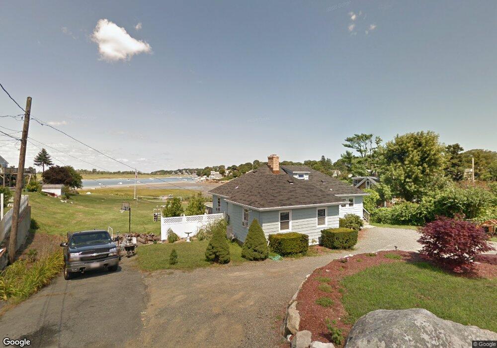
66 Thurston Point Rd Gloucester, MA 01930
Riverview NeighborhoodEstimated Value: $797,379 - $1,093,000
3
Beds
1
Bath
1,582
Sq Ft
$598/Sq Ft
Est. Value
About This Home
This home is located at 66 Thurston Point Rd, Gloucester, MA 01930 and is currently estimated at $945,595, approximately $597 per square foot. 66 Thurston Point Rd is a home located in Essex County with nearby schools including Beeman Memorial, Ralph B O'maley Middle School, and Gloucester High School.
Ownership History
Date
Name
Owned For
Owner Type
Purchase Details
Closed on
Mar 12, 2021
Sold by
Harvey Philip E
Bought by
Harvey Mary B and Harvey Philip E
Current Estimated Value
Purchase Details
Closed on
Aug 9, 2011
Sold by
Harvey Rt
Bought by
Harvey 3Rd Philip E
Create a Home Valuation Report for This Property
The Home Valuation Report is an in-depth analysis detailing your home's value as well as a comparison with similar homes in the area
Home Values in the Area
Average Home Value in this Area
Purchase History
We collect this data history from publicly available records. To have your information removed, we recommend requesting removal directly through your county’s website.
| Date | Buyer | Sale Price | Title Company |
|---|---|---|---|
| Harvey Mary B | -- | None Available | |
| Harvey 3Rd Philip E | -- | -- |
Source: Public Records
Mortgage History
We collect this data history from publicly available records. To have your information removed, we recommend requesting removal directly through your county’s website.
| Date | Status | Borrower | Loan Amount |
|---|---|---|---|
| Previous Owner | Harvey 3Rd Philip E | $200,000 |
Source: Public Records
Tax History
| Year | Tax Paid | Tax Assessment Tax Assessment Total Assessment is a certain percentage of the fair market value that is determined by local assessors to be the total taxable value of land and additions on the property. | Land | Improvement |
|---|---|---|---|---|
| 2025 | $7,400 | $761,300 | $374,200 | $387,100 |
| 2024 | $7,316 | $751,900 | $356,500 | $395,400 |
| 2023 | $7,307 | $690,000 | $318,300 | $371,700 |
| 2022 | $6,851 | $584,100 | $270,600 | $313,500 |
| 2021 | $6,843 | $550,100 | $246,100 | $304,000 |
| 2020 | $6,486 | $526,000 | $246,100 | $279,900 |
| 2019 | $6,486 | $511,100 | $246,100 | $265,000 |
| 2018 | $6,465 | $500,000 | $246,100 | $253,900 |
| 2017 | $6,292 | $477,000 | $234,300 | $242,700 |
| 2016 | $6,062 | $445,400 | $235,100 | $210,300 |
| 2015 | $5,991 | $438,900 | $235,100 | $203,800 |
Source: Public Records
Map
Nearby Homes
- 6 Corliss Ave
- 498 Washington St
- 457 Washington St Unit 2
- 6-8 Joppa Way
- 10 Riverview Way Unit A
- 31 Echo Ave
- 167 Atlantic St
- 178 Atlantic St
- 672 Washington St
- 35 Reservoir Rd
- 5R Brooks Rd
- 25 Poplar St
- 226 Atlantic St
- 220 Atlantic St
- 3 Acacia St
- 65 Leonard St
- 204 Washington St
- 105 Centennial Ave
- 8 1/2 Myrtle Square
- 21 Harold Ave
- 51 Thurston Point Rd
- 47 Thurston Point Rd
- Lot 11E Road b
- 64 Thurston Point Rd
- 53 Thurston Point Rd
- 62 Thurston Point Rd
- 4 Mako Dr
- 6 Mako Dr
- 2 Cedar Ln
- 1 Mako Dr Unit 1
- 1 Mako Dr
- 68 Thurston Point Rd
- 3 Mako Dr
- 4 Cedar Ln
- 8 Thurston Lane U:2 Unit WINTER RENT
- 8 Thurston Ln
- 8 Thurston Ln Unit 2
- 1 Cedar Ln
- 70 Thurston Point Rd
- 70 Thurston Point Rd Unit 2
Your Personal Tour Guide
Ask me questions while you tour the home.