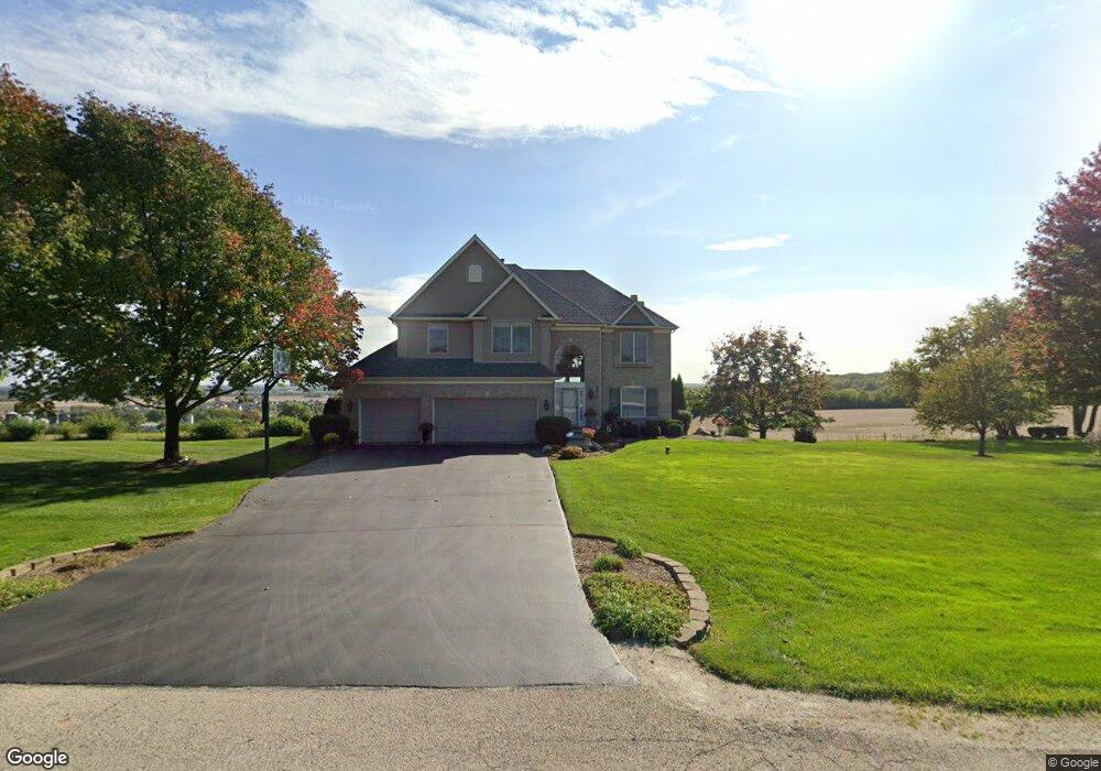
6611 Burning Tree Cir McHenry, IL 60050
Estimated Value: $508,484 - $640,000
Studio
4
Baths
3,607
Sq Ft
$157/Sq Ft
Est. Value
About This Home
This home is located at 6611 Burning Tree Cir, McHenry, IL 60050 and is currently estimated at $565,871, approximately $156 per square foot. 6611 Burning Tree Cir is a home located in McHenry County with nearby schools including Valley View Elementary School and Parkland School.
Ownership History
Date
Name
Owned For
Owner Type
Purchase Details
Closed on
Jul 7, 1998
Sold by
Harris Bank Woodstock
Bought by
Spengel Scott J and Spengel Diana K
Current Estimated Value
Home Financials for this Owner
Home Financials are based on the most recent Mortgage that was taken out on this home.
Original Mortgage
$258,900
Outstanding Balance
$53,536
Interest Rate
7.12%
Mortgage Type
Construction
Estimated Equity
$512,335
Create a Home Valuation Report for This Property
The Home Valuation Report is an in-depth analysis detailing your home's value as well as a comparison with similar homes in the area
Home Values in the Area
Average Home Value in this Area
Purchase History
| Date | Buyer | Sale Price | Title Company |
|---|---|---|---|
| Spengel Scott J | $69,000 | -- |
Source: Public Records
Mortgage History
| Date | Status | Borrower | Loan Amount |
|---|---|---|---|
| Open | Spengel Scott J | $258,900 |
Source: Public Records
Tax History
| Year | Tax Paid | Tax Assessment Tax Assessment Total Assessment is a certain percentage of the fair market value that is determined by local assessors to be the total taxable value of land and additions on the property. | Land | Improvement |
|---|---|---|---|---|
| 2024 | $11,417 | $142,964 | $12,759 | $130,205 |
| 2023 | $11,093 | $128,081 | $11,431 | $116,650 |
| 2022 | $11,729 | $129,475 | $23,481 | $105,994 |
| 2021 | $11,210 | $120,576 | $21,867 | $98,709 |
| 2020 | $10,848 | $115,549 | $20,955 | $94,594 |
| 2019 | $10,696 | $109,722 | $19,898 | $89,824 |
| 2018 | $12,103 | $111,611 | $20,241 | $91,370 |
| 2017 | $11,657 | $104,750 | $18,997 | $85,753 |
| 2016 | $11,301 | $97,897 | $17,754 | $80,143 |
| 2013 | -- | $102,787 | $17,480 | $85,307 |
Source: Public Records
Map
Nearby Homes
- 6522 Sycamore Ct
- 6503 Tustamena Trail
- 7111 Forest Oak Dr
- 7212 Forest Oak Dr
- 7319 Forest Oak Dr
- 1001 Draper Rd
- 7408 Forest Oak Dr
- 507 Legend Ln
- 6708 Homestead Dr
- 7407 Forest Oak Dr
- 715 Legend Ln Unit 715
- 1028 Draper Rd
- 1029 Draper Rd
- 7415 Forest Oak Dr
- 1053 Carrick Ln Unit 1053
- 6409 Donegal Ln
- 1420 Draper Rd
- 1358 Draper Rd Unit 254
- 1246 Draper Rd
- 1241 Draper Rd
- 6607 Burning Tree Cir
- 6610 Burning Tree Cir
- 6615 Burning Tree Cir
- 6604 Burning Tree Cir
- 6619 Burning Tree Cir
- 6805 Burning Tree Cir
- 6519 Burning Tree Cir Unit 3
- 6715 Burning Tree Cir
- 6823 Burning Tree Cir
- 6702 Burning Tree Cir
- 6829 Burning Tree Cir
- 6808 Burning Tree Cir
- 6718 Burning Tree Cir
- 6712 Burning Tree Cir
- 6618 Burning Tree Cir
- 6824 Burning Tree Cir
- 6513 Burning Tree Cir
- 6512 Burning Tree Cir
- 6921 Burning Tree Cir
- 6906 Burning Tree Cir
Your Personal Tour Guide
Ask me questions while you tour the home.