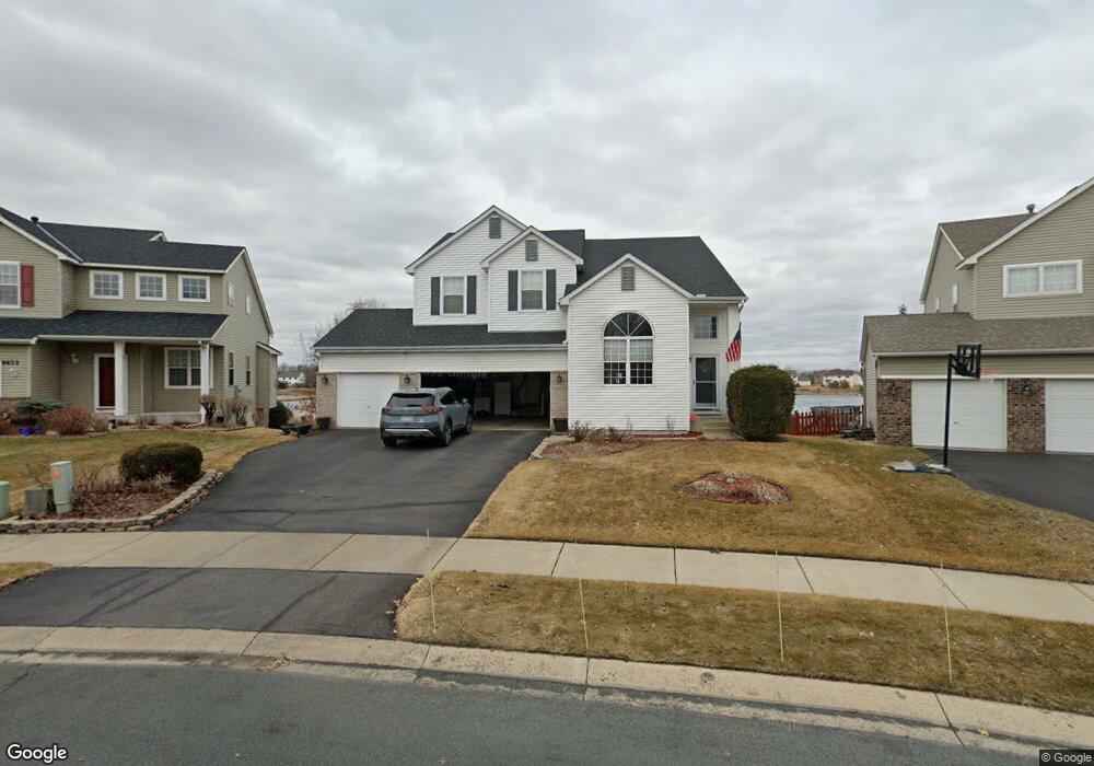
6622 Ashton Cir Shakopee, MN 55379
Estimated Value: $515,000 - $541,000
4
Beds
3
Baths
2,474
Sq Ft
$213/Sq Ft
Est. Value
About This Home
This home is located at 6622 Ashton Cir, Shakopee, MN 55379 and is currently estimated at $528,107, approximately $213 per square foot. 6622 Ashton Cir is a home located in Scott County with nearby schools including Red Oak Elementary School, Shakopee West Middle School, and Shakopee Senior High School.
Ownership History
Date
Name
Owned For
Owner Type
Purchase Details
Closed on
Apr 4, 2024
Sold by
Hagen Todd and Hagen Monique
Bought by
Hagen Revocable Family Trust
Current Estimated Value
Purchase Details
Closed on
Dec 12, 2001
Sold by
Gilbertson Robert E and Gilbertson Susan
Bought by
Hagen Todd A and Hagen Monique M
Purchase Details
Closed on
Mar 30, 2001
Sold by
Feit Richard A and Feit Joanell L
Bought by
Gilbertson Robert E
Purchase Details
Closed on
May 21, 1999
Sold by
Centex Homes Minnesota Division
Bought by
Feit Richard A and Feit Joanell L
Create a Home Valuation Report for This Property
The Home Valuation Report is an in-depth analysis detailing your home's value as well as a comparison with similar homes in the area
Home Values in the Area
Average Home Value in this Area
Purchase History
| Date | Buyer | Sale Price | Title Company |
|---|---|---|---|
| Hagen Revocable Family Trust | -- | None Listed On Document | |
| Hagen Todd A | $295,000 | -- | |
| Gilbertson Robert E | $270,000 | -- | |
| Feit Richard A | $234,035 | -- |
Source: Public Records
Tax History Compared to Growth
Tax History
| Year | Tax Paid | Tax Assessment Tax Assessment Total Assessment is a certain percentage of the fair market value that is determined by local assessors to be the total taxable value of land and additions on the property. | Land | Improvement |
|---|---|---|---|---|
| 2025 | $5,440 | $522,500 | $167,000 | $355,500 |
| 2024 | $5,362 | $514,500 | $163,700 | $350,800 |
| 2023 | $5,404 | $501,800 | $158,900 | $342,900 |
| 2022 | $4,852 | $497,600 | $152,800 | $344,800 |
| 2021 | $4,128 | $384,600 | $138,300 | $246,300 |
| 2020 | $4,578 | $359,400 | $115,300 | $244,100 |
| 2019 | $4,442 | $351,000 | $106,900 | $244,100 |
| 2018 | $4,474 | $0 | $0 | $0 |
| 2016 | $4,336 | $0 | $0 | $0 |
| 2014 | -- | $0 | $0 | $0 |
Source: Public Records
Map
Nearby Homes
- 6869 Falmouth Curve
- 7287 Falmouth Curve
- 7263 Falmouth Curve
- 1463 Ashbourne Cir
- 1789 Windsor Dr S
- 7379 Devin Ln
- 1515 Yorkshire Ln
- 1411 Yorkshire Ln
- 7584 Derby Ln
- 7432 Whitehall Rd
- 1782 Switchgrass Cir
- 2015 Brookview St
- Sheridan & Sheridan C Plan at Whispering Waters
- Preston I & II Plan at Whispering Waters
- Newport Plan at Whispering Waters
- Morgan Plan at Whispering Waters
- Mackenzie Plan at Whispering Waters
- Lincoln II Plan at Whispering Waters
- Highlands Plan at Whispering Waters
- Greystone Plan at Whispering Waters
- 6632 Ashton Cir
- 6612 Ashton Cir
- 6602 Carlisle Curve
- 6642 Ashton Cir
- 6598 Carlisle Curve
- 6652 Ashton Cir
- 6621 Carlisle Curve
- 6611 Carlisle Curve
- 6631 Carlisle Curve
- 6588 Carlisle Curve
- 6658 Ashton Cir
- 6641 Carlisle Curve
- 6591 Carlisle Curve
- 6670 Ashton Cir
- 6651 Carlisle Curve
- 6578 Carlisle Curve
- 6581 Carlisle Curve
- 6676 Ashton Cir
- 6648 Danbury Curve
- 6682 Ashton Cir