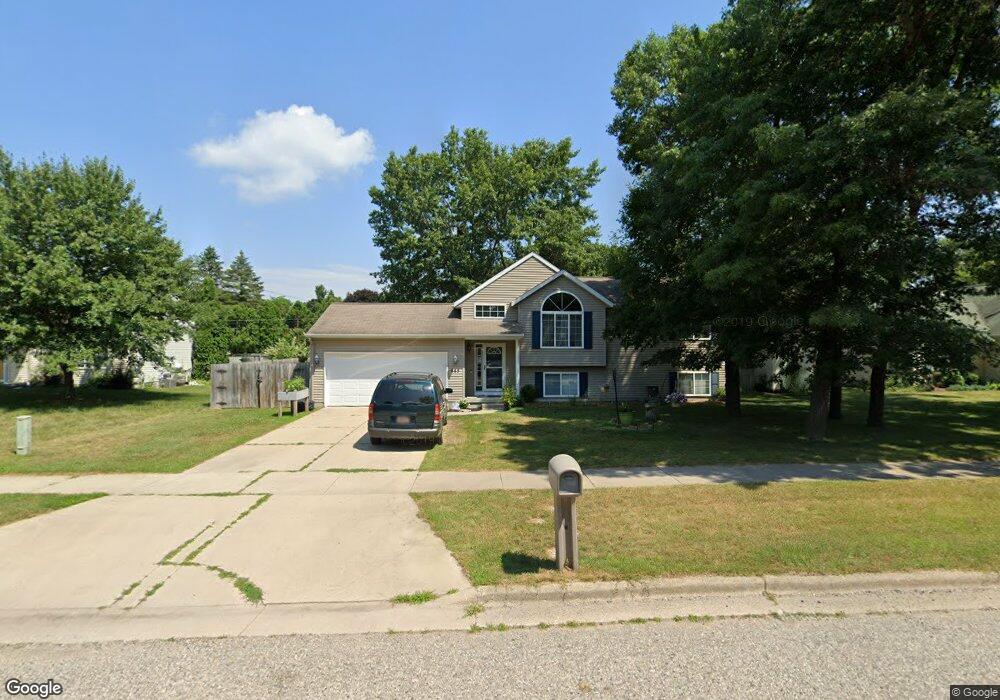
665 Hunt St Lowell, MI 49331
Estimated Value: $310,701 - $369,000
4
Beds
2
Baths
1,000
Sq Ft
$340/Sq Ft
Est. Value
About This Home
This home is located at 665 Hunt St, Lowell, MI 49331 and is currently estimated at $340,175, approximately $340 per square foot. 665 Hunt St is a home located in Kent County with nearby schools including Bushnell Elementary School, Cherry Creek Elementary School, and Lowell Middle School.
Ownership History
Date
Name
Owned For
Owner Type
Purchase Details
Closed on
Jun 11, 2025
Sold by
Mahony Michael and Mahony Michelle Renee
Bought by
Mahony Michelle Renee and Michael And Michelle Mahony Revocable Trust
Current Estimated Value
Purchase Details
Closed on
Apr 14, 2014
Sold by
Sitzer Timothy L and Sitzer Lisa M
Bought by
Mahony Michael
Home Financials for this Owner
Home Financials are based on the most recent Mortgage that was taken out on this home.
Original Mortgage
$157,003
Interest Rate
4.31%
Mortgage Type
FHA
Purchase Details
Closed on
Jun 15, 2000
Bought by
Sitzer Holwerda>Sitzer and Sitzer Timothy L
Purchase Details
Closed on
Jul 21, 1999
Bought by
Sitzer Bloughtrst>Holwerdabldr and Sitzer Timothy L
Create a Home Valuation Report for This Property
The Home Valuation Report is an in-depth analysis detailing your home's value as well as a comparison with similar homes in the area
Home Values in the Area
Average Home Value in this Area
Purchase History
| Date | Buyer | Sale Price | Title Company |
|---|---|---|---|
| Mahony Michelle Renee | -- | None Listed On Document | |
| Mahony Michael | -- | None Listed On Document | |
| Mahony Michael | $159,900 | Chicago Title | |
| Sitzer Holwerda>Sitzer | $25,000 | -- | |
| Sitzer Bloughtrst>Holwerdabldr | $15,000 | -- |
Source: Public Records
Mortgage History
| Date | Status | Borrower | Loan Amount |
|---|---|---|---|
| Previous Owner | Mahony Michael | $157,003 |
Source: Public Records
Tax History
| Year | Tax Paid | Tax Assessment Tax Assessment Total Assessment is a certain percentage of the fair market value that is determined by local assessors to be the total taxable value of land and additions on the property. | Land | Improvement |
|---|---|---|---|---|
| 2025 | $3,357 | $147,700 | $0 | $0 |
| 2024 | $34 | $126,000 | $0 | $0 |
| 2023 | $3,205 | $115,900 | $0 | $0 |
| 2022 | $3,640 | $103,900 | $0 | $0 |
| 2021 | $3,538 | $93,300 | $0 | $0 |
| 2020 | $2,932 | $85,900 | $0 | $0 |
| 2019 | $3,443 | $83,800 | $0 | $0 |
| 2018 | $3,370 | $82,600 | $0 | $0 |
| 2017 | $3,286 | $75,700 | $0 | $0 |
| 2016 | $3,194 | $71,900 | $0 | $0 |
| 2015 | -- | $71,900 | $0 | $0 |
| 2013 | -- | $58,100 | $0 | $0 |
Source: Public Records
Map
Nearby Homes
- 517 Elm St SE
- 913 N Monroe St
- 418 Elm St SE
- 622 N Washington St
- 723 N Washington St
- 607 N Washington St
- 118 N Hudson St SE
- 829 N Jefferson St
- 1080 N Washington St SE
- 705 N Jefferson St
- 1040 N Washington Rd
- 1751 Gee Dr SE
- 320 Roberta Jayne Dr
- 780 Bowes Rd
- 2066 Conservation Trail Unit 13
- 913 Clark St Unit 7
- 1800 W Main St Unit 105
- 1800 W Main St Unit 50
- 517 Front St
- 222 S Division St
Your Personal Tour Guide
Ask me questions while you tour the home.