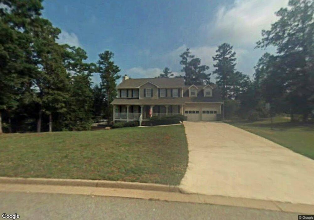
665 Mckenzie Cir Stockbridge, GA 30281
Estimated Value: $324,000 - $338,000
3
Beds
3
Baths
2,340
Sq Ft
$140/Sq Ft
Est. Value
About This Home
This home is located at 665 Mckenzie Cir, Stockbridge, GA 30281 and is currently estimated at $327,836, approximately $140 per square foot. 665 Mckenzie Cir is a home located in Henry County with nearby schools including Woodland Elementary School, Woodland Middle School, and Woodland High School.
Ownership History
Date
Name
Owned For
Owner Type
Purchase Details
Closed on
Dec 14, 1998
Sold by
Hud
Bought by
Harlow Rbt O and Harlow Holly M
Current Estimated Value
Home Financials for this Owner
Home Financials are based on the most recent Mortgage that was taken out on this home.
Original Mortgage
$138,380
Interest Rate
6.8%
Mortgage Type
VA
Purchase Details
Closed on
May 5, 1998
Sold by
Rowland David A and Rowland Donna L
Bought by
Norwest Mtg
Purchase Details
Closed on
May 13, 1994
Sold by
Ga Homes
Bought by
Rowland David Donna
Home Financials for this Owner
Home Financials are based on the most recent Mortgage that was taken out on this home.
Original Mortgage
$114,059
Interest Rate
8.48%
Mortgage Type
FHA
Create a Home Valuation Report for This Property
The Home Valuation Report is an in-depth analysis detailing your home's value as well as a comparison with similar homes in the area
Home Values in the Area
Average Home Value in this Area
Purchase History
| Date | Buyer | Sale Price | Title Company |
|---|---|---|---|
| Harlow Rbt O | -- | -- | |
| Norwest Mtg | $124,100 | -- | |
| Rowland David Donna | $116,900 | -- |
Source: Public Records
Mortgage History
| Date | Status | Borrower | Loan Amount |
|---|---|---|---|
| Previous Owner | Harlow Rbt O | $138,380 | |
| Previous Owner | Rowland David Donna | $114,059 |
Source: Public Records
Tax History Compared to Growth
Tax History
| Year | Tax Paid | Tax Assessment Tax Assessment Total Assessment is a certain percentage of the fair market value that is determined by local assessors to be the total taxable value of land and additions on the property. | Land | Improvement |
|---|---|---|---|---|
| 2025 | $3,711 | $128,880 | $18,000 | $110,880 |
| 2024 | $3,711 | $126,160 | $18,000 | $108,160 |
| 2023 | $3,230 | $126,320 | $16,000 | $110,320 |
| 2022 | $3,165 | $102,160 | $12,000 | $90,160 |
| 2021 | $2,782 | $85,960 | $12,000 | $73,960 |
| 2020 | $2,563 | $76,720 | $10,800 | $65,920 |
| 2019 | $2,512 | $74,560 | $10,800 | $63,760 |
| 2018 | $2,373 | $68,640 | $10,000 | $58,640 |
| 2016 | $1,924 | $55,520 | $10,000 | $45,520 |
| 2015 | $1,699 | $48,600 | $7,200 | $41,400 |
| 2014 | $1,575 | $45,080 | $7,200 | $37,880 |
Source: Public Records
Map
Nearby Homes
- 0 Mckenzie Ave Unit 10593345
- 564 Mckenzie Ave
- 608 Mckenzie Cir
- 320 Mckenzie Dr
- 719 Erin Dr
- 164 Mckenzie Ct
- 805 Anna Kathryn Dr
- 825 Anna Kathryn Dr
- 809 Anna Kathryn Dr
- 807 Anna Kathryn Dr
- 829 Anna Kathryn Dr
- 830 Anna Kathryn Dr
- 811 Anna Kathryn Dr
- 831 Anna Kathryn Dr
- 813 Anna Kathryn Dr
- 551 Hood Rd
- 1720 Highway 138 E
- 95 Fern Ct
- 65 Wynfield Dr
- 1810 Highway 138 E
- 673 Mckenzie Cir
- 657 Mckenzie Cir
- 527 Mckenzie Ave
- 511 Mckenzie Ave
- 664 Mckenzie Cir
- 672 Mckenzie Cir
- 649 Mckenzie Cir
- 656 Mckenzie Cir
- 1 Mckenzie Ave
- 0 Mckenzie Ave Unit 3277956
- 0 Mckenzie Ave Unit 8461956
- 0 Mckenzie Ave Unit 8204844
- 0 Mckenzie Ave Unit 7541296
- 0 Mckenzie Ave Unit 8822376
- 0 Mckenzie Ave Unit 7073576
- 0 Mckenzie Ave
- 684 Mckenzie Cir
- 680 Mckenzie Cir
- 503 Mckenzie Ave
- 529 Mckenzie Ave