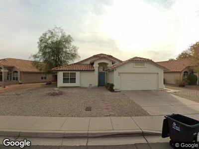
665 W Smoke Tree Rd Gilbert, AZ 85233
Downtown Gilbert NeighborhoodEstimated Value: $391,776 - $468,000
--
Bed
2
Baths
1,372
Sq Ft
$320/Sq Ft
Est. Value
About This Home
This home is located at 665 W Smoke Tree Rd, Gilbert, AZ 85233 and is currently estimated at $439,194, approximately $320 per square foot. 665 W Smoke Tree Rd is a home located in Maricopa County with nearby schools including Gilbert Elementary School, Mesquite Junior High School, and Mesquite High School.
Ownership History
Date
Name
Owned For
Owner Type
Purchase Details
Closed on
Mar 25, 2005
Sold by
Osmont Wahl Christopher J
Bought by
Plante Lisa A
Current Estimated Value
Home Financials for this Owner
Home Financials are based on the most recent Mortgage that was taken out on this home.
Original Mortgage
$10,000
Interest Rate
5.74%
Mortgage Type
Credit Line Revolving
Purchase Details
Closed on
May 20, 2002
Sold by
Mcclurg William W
Bought by
Osmont Wahl Christopher J and Plante Lisa A
Home Financials for this Owner
Home Financials are based on the most recent Mortgage that was taken out on this home.
Original Mortgage
$136,965
Interest Rate
6.94%
Mortgage Type
New Conventional
Purchase Details
Closed on
Apr 12, 1999
Sold by
Lipsey John J and Lipsey Faye M
Bought by
Mcclurg William W
Home Financials for this Owner
Home Financials are based on the most recent Mortgage that was taken out on this home.
Original Mortgage
$125,950
Interest Rate
6.98%
Mortgage Type
VA
Create a Home Valuation Report for This Property
The Home Valuation Report is an in-depth analysis detailing your home's value as well as a comparison with similar homes in the area
Home Values in the Area
Average Home Value in this Area
Purchase History
| Date | Buyer | Sale Price | Title Company |
|---|---|---|---|
| Plante Lisa A | -- | Stewart Title & Trust Of Pho | |
| Osmont Wahl Christopher J | $138,900 | Stewart Title & Trust | |
| Mcclurg William W | $123,500 | Lawyers Title Of Arizona Inc |
Source: Public Records
Mortgage History
| Date | Status | Borrower | Loan Amount |
|---|---|---|---|
| Open | Plante Lisa A | $190,000 | |
| Closed | Plante Lisa A | $184,800 | |
| Closed | Plante Lisa A | $180,000 | |
| Closed | Plante Lisa Ann | $10,000 | |
| Closed | Plante Lisa A | $140,000 | |
| Previous Owner | Osmont Wahl Christopher J | $139,035 | |
| Previous Owner | Osmont Wahl Christopher J | $136,965 | |
| Previous Owner | Mcclurg William W | $125,950 | |
| Closed | Plante Lisa A | $17,500 |
Source: Public Records
Tax History Compared to Growth
Tax History
| Year | Tax Paid | Tax Assessment Tax Assessment Total Assessment is a certain percentage of the fair market value that is determined by local assessors to be the total taxable value of land and additions on the property. | Land | Improvement |
|---|---|---|---|---|
| 2025 | $1,384 | $18,927 | -- | -- |
| 2024 | $1,392 | $18,025 | -- | -- |
| 2023 | $1,392 | $31,350 | $6,270 | $25,080 |
| 2022 | $1,351 | $23,430 | $4,680 | $18,750 |
| 2021 | $1,428 | $22,370 | $4,470 | $17,900 |
| 2020 | $1,403 | $21,070 | $4,210 | $16,860 |
| 2019 | $1,291 | $18,410 | $3,680 | $14,730 |
| 2018 | $1,254 | $16,980 | $3,390 | $13,590 |
| 2017 | $1,211 | $15,570 | $3,110 | $12,460 |
| 2016 | $1,252 | $14,910 | $2,980 | $11,930 |
| 2015 | $1,140 | $13,660 | $2,730 | $10,930 |
Source: Public Records
Map
Nearby Homes
- 626 W Catclaw St
- 510 S Saddle St
- 686 W Sereno Dr
- 556 W Sagebrush St
- 515 W Smoke Tree Rd
- 826 W Royal Palms Dr
- 659 S Dodge St
- 662 S Saddle St
- 821 W Sun Coast Dr
- 844 W Emerald Island Dr
- 605 S Monterey St
- 714 W Mesquite St
- 418 W Sagebrush St
- 824 W Mesquite St
- 510 W Amoroso Dr
- 862 W Rawhide Ave
- 854 W Mesquite St
- 1022 W Calypso Ct
- 343 S Cholla St
- 234 S Neely St
- 665 W Smoke Tree Rd
- 709 W Smoke Tree Rd
- 657 W Smoke Tree Rd
- 708 W Sagebrush St
- 717 W Smoke Tree Rd
- 442 S Quail Ln
- 425 S Abilene Dr
- 716 W Sagebrush St
- 501 S Abilene Dr
- 725 W Smoke Tree Rd
- 450 S Quail Ln
- 716 W Smoke Tree Rd
- 724 W Sagebrush St
- 417 S Abilene Dr
- 649 W Smoke Tree Rd
- 509 S Abilene Dr
- 724 W Smoke Tree Rd
- 502 S Quail Ln
- 733 W Smoke Tree Rd
- 732 W Sagebrush St