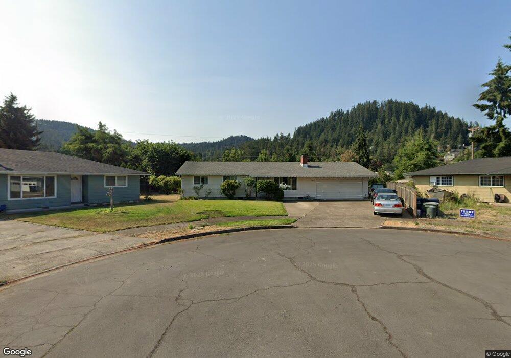
6651 A St Springfield, OR 97478
Thurston NeighborhoodEstimated Value: $352,000 - $399,000
3
Beds
2
Baths
1,066
Sq Ft
$354/Sq Ft
Est. Value
About This Home
This home is located at 6651 A St, Springfield, OR 97478 and is currently estimated at $377,488, approximately $354 per square foot. 6651 A St is a home located in Lane County with nearby schools including Ridgeview Elementary School, Thurston Middle School, and Thurston High School.
Ownership History
Date
Name
Owned For
Owner Type
Purchase Details
Closed on
Sep 1, 2000
Sold by
Va
Bought by
Biss George R
Current Estimated Value
Home Financials for this Owner
Home Financials are based on the most recent Mortgage that was taken out on this home.
Original Mortgage
$106,811
Outstanding Balance
$37,574
Interest Rate
8.19%
Mortgage Type
FHA
Estimated Equity
$339,914
Purchase Details
Closed on
Aug 10, 2000
Sold by
Biss George R
Bought by
Deschenes Stephen M
Home Financials for this Owner
Home Financials are based on the most recent Mortgage that was taken out on this home.
Original Mortgage
$106,811
Outstanding Balance
$37,574
Interest Rate
8.19%
Mortgage Type
FHA
Estimated Equity
$339,914
Create a Home Valuation Report for This Property
The Home Valuation Report is an in-depth analysis detailing your home's value as well as a comparison with similar homes in the area
Home Values in the Area
Average Home Value in this Area
Purchase History
| Date | Buyer | Sale Price | Title Company |
|---|---|---|---|
| Biss George R | $42,500 | Evergreen Land Title Co | |
| Deschenes Stephen M | $107,500 | Evergreen Land Title Co |
Source: Public Records
Mortgage History
| Date | Status | Borrower | Loan Amount |
|---|---|---|---|
| Open | Deschenes Stephen M | $106,811 |
Source: Public Records
Tax History Compared to Growth
Tax History
| Year | Tax Paid | Tax Assessment Tax Assessment Total Assessment is a certain percentage of the fair market value that is determined by local assessors to be the total taxable value of land and additions on the property. | Land | Improvement |
|---|---|---|---|---|
| 2025 | $3,117 | $169,976 | -- | -- |
| 2024 | $3,066 | $165,026 | -- | -- |
| 2023 | $3,066 | $160,220 | $0 | $0 |
| 2022 | $2,840 | $155,554 | $0 | $0 |
| 2021 | $2,789 | $151,024 | $0 | $0 |
| 2020 | $2,708 | $146,626 | $0 | $0 |
| 2019 | $2,626 | $142,356 | $0 | $0 |
| 2018 | $2,476 | $134,184 | $0 | $0 |
| 2017 | $2,381 | $134,184 | $0 | $0 |
| 2016 | $2,330 | $130,276 | $0 | $0 |
| 2015 | $2,264 | $126,482 | $0 | $0 |
| 2014 | $2,230 | $122,798 | $0 | $0 |
Source: Public Records
Map
Nearby Homes
- 250 68th St
- 296 65th St
- 6445 B St
- 6451 Dogwood St
- 0 S 67th St Unit 693960327
- 320 Mountaingate Dr
- 0 Forest Ridge Unit 520732026
- 6964 Bluebelle Way
- 595 S 68th Place
- 482 Laksonen Loop
- 0 Forest Ridge Dr Unit 637211360
- 0 Forest Ridge Dr Unit 298125461
- 0 Forest Ridge Dr Unit 415181610
- 6225 Forest Ridge Dr
- 515 70th St
- 0 71st St
- 0 S 69th Place
- 6035 Fernhill Loop
- 6831 Holly St
- 5995 Main St